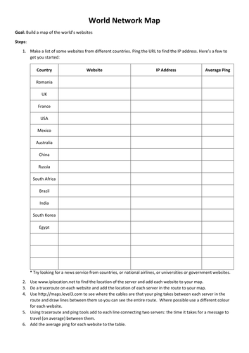

An activity using various tools to help students build a map of *their* Internet. They start by identifying some websites in different countries then using various ping, traceroute and geolocation tools to build a map of the journey a packet takes from their computer across the Internet to each website. They then add average ping times to see the time it takes for messages to travel around the world over the Internet.
Can be a group or individual activity. Each group will also need a world map, such as this one https://www.tes.com/teaching-resource/world-map-3000292 The larger you can print the map the better the end result. Or alternatively you could use the Google Maps 'My Maps' tools to accomplish the same thing.
You will need to show students how to use ping and traceroute commands on whichever OS you are using.
Findings from all groups can be added to large-format wall map as a display, perhaps using pins, labels and string?
Something went wrong, please try again later.
This resource hasn't been reviewed yet
To ensure quality for our reviews, only customers who have downloaded this resource can review it
Report this resourceto let us know if it violates our terms and conditions.
Our customer service team will review your report and will be in touch.
£0.00