Mountain Environments is a Geography unit suitable for KS2 (Y4-6) and has everything you need for covering a mountains topic.
The planning overview, topic title page and vocabulary page can be downloaded for free here. Lessons include:
L1 – Identifying the key features of mountains
L2 – Identifying the world’s major mountain ranges
L3 – Locating the world’s famous mountains using latitude and longitude
L4 – Understanding how fold mountains are formed
L5 – Investigating the structure of a volcano (FREE)
L6 – Researching famous world mountains (FREE)
L7 – Investigating mountain climates
Each lesson includes a presentation and differentiated activities/worksheets.
If you like this resource, we would appreciate a review! We will happily send you a free resource in return for a review or useful suggestions/feedback. Contact us at ed@teachitforward.co.uk.
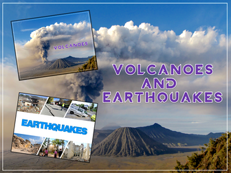
Volcanoes & Earthquakes is an exciting extended Geography unit designed for students in KS2.
The planning overview, topic title page and vocabulary page can be downloaded for free here. Lessons include:
L1 – Understanding the structure of the Earth
L2 – Investigating the structure of a volcano (FREE)
L3 – Locating the world’s famous volcanoes
L4 – Investigating the five deadly features of a volcanic eruption
L5 – Understanding tectonic plates
L6 – Exploring the effects of volcanic eruptions on Montserrat
L7 – Why do people live near volcanoes?
L8 – Understanding the causes of earthquakes
L9 – Investigating the five deadly features of an earthquake
L10 – Researching earthquakes using Wikipedia
L11 – Locating the world’s biggest earthquakes using latitude & longitude
L12 – Writing a fact file about a famous earthquake
Each lesson includes a presentation and differentiated activities/worksheets.
A FREE newspaper report template is also included in this unit.
If you like this resource, we would appreciate a review! We will happily send you a free resource in return for a review or useful suggestions/feedback. Contact us at ed@teachitforward.co.uk.
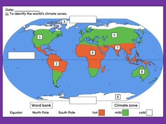
This lesson is an ideal introduction to the world’s three main climate zones.
It is part of Our World, a Geography unit designed for students in KS1 and lower KS2 (Y1-3), but can also be taught as a stand alone lesson.
First the presentation helps students understand that different places in the world have different climates. It then looks at the location of the Equator and North/South poles, and how these relate to the three main climate zones. To keep things simple, these are referred to as hot (tropical), mild (temperate) and cold (frigid).
The activity challenges students to locate the Equator and poles and then identify various climate zones around the world. It is differentiated two ways:
Easier – Students identify the climate zone of 8 numbered points around the world.
Harder – Students identify climate zone and continent of 8 numbered points around the world.
Extension – Students cut and stick pictures of four animals – elephant, lion, polar bear and penguin – onto their world climate zone map.
If you like this resource, we would appreciate a review! We will happily send you a free resource in return for a review or useful suggestions/feedback. Contact us at ed@teachitforward.co.uk.
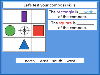
This lesson is an ideal introduction to compass directions for younger children.
It is part of Our World, a Geography unit designed for students in KS1 and lower KS2 (Y1-3), but can also be taught as a stand alone lesson.
The presentation introduces the four cardinal points of the compass (North, East, South and West). It then challenges students to describe the position of objects using these compass directions.
The activity worksheets are differentiated two ways:
Easier – Students describe the position of objects using compass directions (simple questions).
Harder – Students describe the position of objects using compass directions (mixed questions).
Extension – Students fill in the blanks on a compass using different vocabulary.
If you like this resource, we would appreciate a review! We will happily send you a free resource in return for a review or useful suggestions/feedback. Contact us at ed@teachitforward.co.uk.
This lesson is part of Mountain Environments, a Geography unit designed for students in upper KS2 (Y4-6).
First the presentation introduces some of the most famous mountain ranges from around the world.
The differentiated activity then challenges students to locate the world’s mountain ranges and encourages them to use and explore atlases. It is recommended that students do the activity in pairs.
Easier – Students identify the world’s famous mountain ranges (less writing).
Medium – Students identify the world’s famous mountain ranges (first letter clues)
Harder – Students identify the world’s famous mountain ranges (no clues)
If you like this resource, we would appreciate a review! We will happily send you a free resource in return for a review or useful suggestions/feedback. Contact us at ed@teachitforward.co.uk.
An outstanding Anglo-Saxons and Vikings unit that covers all you need to know. Suitable for Y4/Y5 but can be adapted to Y3 or Y6 easily. All worksheets needed provided and detailed PowerPoints for each lesson. Detailed planning also provided. Includes:
L.O. To understand who the Vikings were and how they lived.
Success Criteria
I know the countries the Vikings came from
I know when they lived
I know a little about why they came to England
I know about their everyday life
L.O. To understand what made the Viking longboat so successful
Success Criteria
I know what the keel is and why it helped the boat to move through the water
I know what the sail was made from
I know the materials the longships were made of
I know why there was a carved masthead
I can show what I know by labeling my drawing
L.O. To understand why the Vikings traveled to England and why some chose to settle here
Success Criteria
I can work with my team to produce and trade goods
By the end of the lesson I will know what difficulties the Vikings faced and why some chose to stay in England.
and 5. L.O. To understand why the Vikings raided Lindisfarne and describe the events through poetry.
Success Criteria
I understand the events of Lindisfarne including why the Vikings raided
I can understand the feelings of both sides of the raid
I can chose interesting vocabulary to show what I know through my poem
and 7. L.O. To understand who the Anglo-Saxons were and how they lived
Success Criteria
I know the countries the Anglos and Saxons came from
I know when they lived
I know a little about why they came to England
I know about their everyday life
L.O. To be able to use the internet to research an area of Viking life
Success Criteria
I can use google to search for information by typing in key words
I can make notes about what I have read- not just copy!
I can share my facts with detail
I can make notes based on other children’s facts
L.O. To know facts about Viking gods and show what I know through drawing
and labelling a picture.
Success Criteria
Make notes about some of the Viking gods
Use these notes to draw and label my favourite god
L.O. To be able to discuss open ended questions linked to the Vikings
Success Criteria
Listen to others - don’t interrupt
If you want to talk, hold out your hand
Respond to what others have said
Try to join in
Have any issues with this resource or a request? Contact us directly for the quickest response at: explore_education@outlook.com
KS2 History year 3 year 4 year 5 year 6 knowledge skills lks2 uks2 long ship longship
A series of 8 lessons covering the environment. All PowerPoints and tasks are completely editable. Covering the various types of pollution, renewable energy and what we can do to help protect our environment.
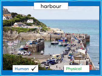
This lesson is part of The Seaside, a Geography unit designed for students in KS1 and lower KS2, but can also be taught as a stand alone lesson.
The presentation first explains the difference between human and physical geographical features. It then challenges students to identify a range of seaside features (e.g. cliffs, lighthouse, river mouth) and classify them as human or physical.
In the activity, students identify a range of seaside features and classify them as human or physical.
Easier - Students classify seaside features as human or physical.
Medium - Students label seaside features (with initial letter clues) and classify them as human or physical.
Harder - Students label seaside features (no clues) and classify them as human or physical.
Extension - Students unscramble sentences about the seaside.
If you like this resource, we would appreciate a review! We will happily send you a free resource in return for a review or useful suggestions/feedback. Contact us at ed@teachitforward.co.uk.
Have any issues with this resource or a request? Contact us directly for the quickest response at: explore_education@outlook.com
This brilliant unit has five detailed lessons that will help your class learn all about France and it’s physical and human geography.
This can be used flexibly over a half term and covers a range of topics, including:
Map work
Life in France (schools, food and routines)
Sheffield v Paris (can be adapted to any English locality)
Napoleon
Famous French people
Each lesson has a detailed lesson plan, PowerPoint and accompanying resources.
Resources include:
x5 lesson plans
Blank map of Europe
Labelled map of Europe
Blank map of France
Information sheet - French food and drink
Information sheet - French schools
Information sheet - Interview with a British family
School life comparison table worksheet
Information sheet - Paris
Information sheet - Sheffield
Editable worksheet - comparing Paris and Sheffield (PDF also included)
Newspaper template
Storyboard template
Wanted poster template
French history timeline worksheet
French history timeline answers
Names of famous French people to research
Website links to research
Lesson 1: L.O: to know the location of countries in Europe, including France, and to be able to plot human and physical features onto a map.
Success Criteria:
I know where the UK, France, Germany,
Italy and Russia are located in Europe.
I can use the points of the compass to help me to plot human and physical features onto a map.
Lesson 2: L.O: to understand life in France and the differences and similarities to life in the UK
Success Criteria:
I know what a typical school day is like in France.
I know a French person’s typical diet
I can compare life in France to my life in the UK and say what is similar and what is different.
Lesson 3:L.O: to compare the physical and human geography of Paris and Sheffield (or any city near you!)
Success Criteria:
I can locate Paris on a map of France
I can locate Sheffield on a map of the UK
I can compare their physical geography
I can compare their human geography
Lesson 4:L.O: to know the history of France around the time of Napoleon Bonaparte and understand how Napoleon changed Europe.
Success Criteria:
I can make notes using bullet points
I can use a time line to show important events
I can include some of the events and dates in my work.
Lesson 5:L.O: to use the internet to find and present facts.
Success Criteria:
I know some famous French people
I can say why they are famous
I can use Google to find websites with key facts including date of birth, why they were famous and death (if applicable)
I can present these facts as a slide from a PowerPoint
Graded Outstanding by leaders.
UPDATED - 21/12/19 Lesson 3 PowerPoint reuploaded - all errors now cleared.
UPDATED - 16/01/21
UPDATED - 02/02/22 All resources, PowerPoints and lesson plans upgraded
geography history europe ks2 year 3 year 4 year 5 year 6 y3 y4 y5 y6 lks2 uks2
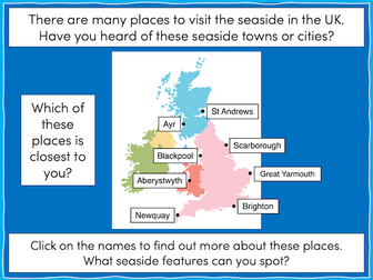
This lesson is part of The Seaside, a Geography unit designed for students in KS1 and lower KS2, but can also be taught as a stand alone lesson.
The presentation takes students on a tour of eight seaside towns and cities around the United Kingdom including: Ayr and St Andrews in Scotland; Aberystwyth in Wales; Blackpool and Newquay in England.
The activity then challenges students to use their map skills to locate these towns and cities on a map of the UK. This can be done using an atlas or the prompt maps included.
Easier - Students label 8 seaside towns and cities using a prompt map.
Medium - Students label 12 seaside towns and cities using a prompt map.
Harder - Students label 12 seaside towns and cities using an atlas.
Extension - Students locate and label 2 further seaside towns and cities from each country of the UK.
If you like this resource, we would appreciate a review! We will happily send you a free resource in return for a review or useful suggestions/feedback. Contact us at ed@teachitforward.co.uk.
This clear, detailed and visually-appealing resource offers a complete reference point for students revising knowledge relating to the United Kingdom, as a part of locational knowledge in geography. It contains comprehensive sections on:
Overview and map;
Counties and Cities of the UK;
Longest Rivers;
Highest Mountains;
Human Geography Features;
Physical Geography Features.
The resource is designed to be printed onto A3, and is provided as both a PDF and a Word version (so that you can edit if you want to). All images used are licensed for commercial use and are cited on a separate document (included). The resource is most suitable for students in KS2 or lower KS3.
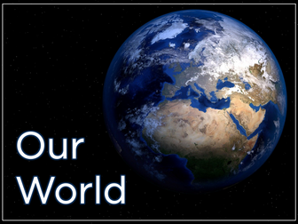
Our World is a comprehensive Geography topic about Planet Earth, suitable for KS1 and lower KS2 (Y1-3).
The planning overview, topic title page and vocabulary page can be downloaded for free here. Lessons include:
L1 – Completing a world map jigsaw
L2 – Identifying the continents and oceans of the world (FREE)
L3 – Where do we live?
L4 – Identifying human and natural features of the world
L5 – Investigating satellite photos of famous world landmarks
L6 – Introduction to compass directions
L7 – Identifying world climate zones
L8 – Identifying the countries and capitals of the UK (FREE)
Each lesson includes a presentation and differentiated activities/worksheets.
If you like this resource, we would appreciate a review! We will happily send you a free resource in return for a review or useful suggestions/feedback. Contact us at ed@teachitforward.co.uk.
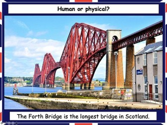
This lesson is part of Exploring the United Kingdom, a Geography unit designed for KS1 and lower KS2 (Y2-4).
The presentation helps students understand the difference between human and physical geographical features. It then challenges them to classify famous UK landmarks as either human or physical.
There are two engaging activities included:
Partner activity:
Students sort pictures/descriptions of UK landmarks into human and physical geographical features.
Individual activity:
Students match pictures of UK landmarks to their descriptions. This is differentiated three ways:
Easier – Students match 8 features to their descriptions.
Medium – Students match 12 features to their descriptions.
Harder – Students write a description of each UK landmark using a word bank.
Extension – Students sort the UK landmarks into human and physical geographical features.
If you like this resource, we would appreciate a review! We will happily send you a free resource in return for a review or useful suggestions/feedback. Contact us at ed@teachitforward.co.uk.
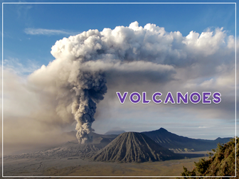
Volcanoes is an exciting Geography unit designed for students in KS2.
The planning overview, topic title page and vocabulary page can be downloaded for free here. Lessons include:
L1 – Understanding the structure of the Earth
L2 – Investigating the structure of a volcano (FREE)
L3 – Locating the world’s famous volcanoes
L4 – Investigating the five deadly features of a volcanic eruption
L5 – Understanding tectonic plates
L6 – Exploring the effects of volcanic eruptions on Montserrat
L7 – Why do people live near volcanoes?
Each lesson includes a presentation and differentiated activities/worksheets.
A FREE newspaper report template is also included in this unit.
If you like this resource, we would appreciate a review! We will happily send you a free resource in return for a review or useful suggestions/feedback. Contact us at ed@teachitforward.co.uk.
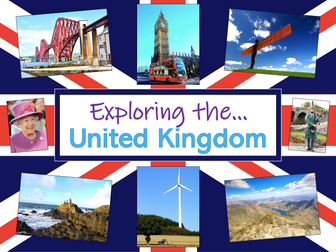
Exploring the UK is a Geography unit suitable for KS1 and lower KS2 (Y2-4).
The planning overview, topic title page and vocabulary page can be downloaded for free here. Lessons include:
L1 – Identifying the countries and capitals of the UK & Ireland (FREE)
L2 – Locating UK cities using compass directions
L3 – Identifying human & physical features of the UK
L4 – Investigating satellite photos of the UK
L5 – Comparing the city and the countryside
L6– Identifying famous features and characteristics of countries of the UK
L7 – Identifying flags of the United Kingdom
L8 – Identifying the four seasons of weather in the UK
Optional lesson – Identifying the countries and capital cities of Europe
Each lesson includes a presentation and differentiated activities/worksheets.
If you like this resource, we would appreciate a review! We will happily send you a free resource in return for a review or useful suggestions/feedback. Contact us at ed@teachitforward.co.uk.
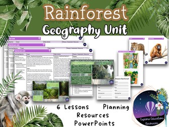
Enhance your Key Stage 2 curriculum with our outstanding Rainforest Unit - a comprehensive set of six engaging geography lessons meticulously designed to foster an in-depth understanding of rainforests. This resource is a valuable addition to your teaching toolkit, complete with detailed lesson plans, informative PowerPoints, and student-focused worksheets.
Lesson 1: Rainforest Regions and Significance
In this lesson, students will identify the continents hosting rainforests, label a world map with major rainforest regions, and grasp the significance of rainforests for Earth’s biodiversity. The lesson starts with an intriguing Rainforest Wonder Box activity, setting the tone for exploration.
Lesson 2: Rainforest Climate and Adaptations
Students will explore the climate characteristics of rainforests, understand why they are called “rainforests,” and identify adaptations of animals and plants. The lesson fosters critical thinking and understanding of how species thrive in rainforest conditions.
Lesson 3: Layers of the Rainforest
This lesson delves into the various layers of the rainforest, highlighting the unique organisms that inhabit each layer. Students will create engaging visual representations of rainforest layers, enhancing their knowledge of the intricate ecosystems.
Lesson 4: Rainforest Animals and Plants
Students will categorize and differentiate between rainforest animals and plants, gaining insights into the rich diversity of rainforest life. Engaging activities, including “Categorising Organisms” and “Rainforest Habitat Diorama,” deepen their comprehension.
Lesson 5: Amazon Rainforest vs. UK Forest
Comparing the Amazon rainforest and a UK forest, students will identify differences and similarities, understand biodiversity, and explore the importance of these ecosystems. The lesson encourages critical thinking and insightful discussions.
Lesson 6: Rainforest Conservation and Action
In the final lesson, students will comprehend the significance of rainforest conservation and discover ways to contribute. Engaging activities like creating conservation posters or slogans empower students to express their commitment to preserving these vital environments.
Our unit equips educators with everything needed for an engaging rainforest unit, including PowerPoint presentations, visual aids, worksheets, and hands-on activities. Promote geographical understanding, critical thinking, and environmental awareness with our Rainforest Unit.
Have any issues with this resource or a request? Contact us directly for the quickest response at: explore_education@outlook.com
Tags: Key Stage 2, Geography, Rainforest, Biodiversity, Conservation, Ecosystem, Climate, Adaptations, Critical Thinking, Interactive, Engaging, Curriculum, Lesson Plans, PowerPoints, Worksheets, interview, ofsted, observation
A simple coloured world map with coordinates. Children can use the map to become familiar with countries, continents, oceans and seas! Also using their coordinates skills. Can be printed A4/A3 depending on use.
A map skills homework booklet for use with KS3 Geography classes.
An amalgamation of worksheets I have gathered over the years to create a comprehensive and easy to mark Map Skills Homework Booklet!
A quick worksheet where children can match map symbols to their meanings. Makes a good starter for a Geography lessons using ordnance survey (OS) maps.
The Great Plant Hunt develops children’s understanding of the natural world and is an ideal free resource to help you teach the primary science curriculum. In this teachers booklet you will find activities for 7-8 year-olds. They offer a range of opportunities for pupils to think critically. For fun extras and further information visit: http://www.greatplanthunt.org/yeargroup-3 The Great Plant Hunt is produced by Royal Botanic Gardens, Kew and funded by the Wellcome Trust.
 Quick View