Mountain Environments - KS2Quick View
TeachItForwardTeachItForward

Mountain Environments - KS2

8 Resources
Mountain Environments is a Geography unit suitable for KS2 (Y4-6) and has everything you need for covering a mountains topic. The planning overview, topic title page and vocabulary page can be downloaded for free here. Lessons include: L1 – Identifying the key features of mountains L2 – Identifying the world’s major mountain ranges L3 – Locating the world’s famous mountains using latitude and longitude L4 – Understanding how fold mountains are formed 
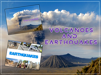
L5 – Investigating the structure of a volcano (FREE) L6 – Researching famous world mountains (FREE) 
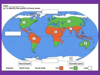
L7 – Investigating mountain climates Each lesson includes a presentation and differentiated activities/worksheets. If you like this resource, we would appreciate a review! We will happily send you a free resource in return for a review or useful suggestions/feedback. Contact us at ed@teachitforward.co.uk.
Volcanoes & Earthquakes - KS2Quick View
TeachItForwardTeachItForward

Volcanoes & Earthquakes - KS2

14 Resources
Volcanoes & Earthquakes is an exciting extended Geography unit designed for students in KS2. The planning overview, topic title page and vocabulary page can be downloaded for free here. Lessons include: L1 – Understanding the structure of the Earth L2 – Investigating the structure of a volcano (FREE) L3 – Locating the world’s famous volcanoes L4 – Investigating the five deadly features of a volcanic eruption L5 – Understanding tectonic plates L6 – Exploring the effects of volcanic eruptions on Montserrat L7 – Why do people live near volcanoes? L8 – Understanding the causes of earthquakes L9 – Investigating the five deadly features of an earthquake L10 – Researching earthquakes using Wikipedia L11 – Locating the world’s biggest earthquakes using latitude & longitude L12 – Writing a fact file about a famous earthquake Each lesson includes a presentation and differentiated activities/worksheets. A FREE newspaper report template is also included in this unit. If you like this resource, we would appreciate a review! We will happily send you a free resource in return for a review or useful suggestions/feedback. Contact us at ed@teachitforward.co.uk.
Identifying the world's climate zones - KS1/KS2Quick View
TeachItForwardTeachItForward

Identifying the world's climate zones - KS1/KS2

(3)
This lesson is an ideal introduction to the world’s three main climate zones. It is part of Our World, a Geography unit designed for students in KS1 and lower KS2 (Y1-3), but can also be taught as a stand alone lesson. First the presentation helps students understand that different places in the world have different climates. It then looks at the location of the Equator and North/South poles, and how these relate to the three main climate zones. To keep things simple, these are referred to as hot (tropical), mild (temperate) and cold (frigid). The activity challenges students to locate the Equator and poles and then identify various climate zones around the world. It is differentiated two ways: Easier – Students identify the climate zone of 8 numbered points around the world. Harder – Students identify climate zone and continent of 8 numbered points around the world. Extension – Students cut and stick pictures of four animals – elephant, lion, polar bear and penguin – onto their world climate zone map. If you like this resource, we would appreciate a review! We will happily send you a free resource in return for a review or useful suggestions/feedback. Contact us at ed@teachitforward.co.uk.
Locating seaside towns and cities in the UK - KS1/KS2Quick View
TeachItForwardTeachItForward

Locating seaside towns and cities in the UK - KS1/KS2

(1)
This lesson is part of The Seaside, a Geography unit designed for students in KS1 and lower KS2, but can also be taught as a stand alone lesson. The presentation takes students on a tour of eight seaside towns and cities around the United Kingdom including: Ayr and St Andrews in Scotland; Aberystwyth in Wales; Blackpool and Newquay in England. The activity then challenges students to use their map skills to locate these towns and cities on a map of the UK. This can be done using an atlas or the prompt maps included. Easier - Students label 8 seaside towns and cities using a prompt map. Medium - Students label 12 seaside towns and cities using a prompt map. Harder - Students label 12 seaside towns and cities using an atlas. Extension - Students locate and label 2 further seaside towns and cities from each country of the UK. If you like this resource, we would appreciate a review! We will happily send you a free resource in return for a review or useful suggestions/feedback. Contact us at ed@teachitforward.co.uk.
ULTIMATE ultimate construction area bundleQuick View
lauraloo7lauraloo7

ULTIMATE ultimate construction area bundle

8 Resources
Featuring ALL construction resources available in my shop including the two new items: constructiion area heading cards and also the KS1 History construction area cards (both new for Summer 2023). The bundle also includes: design sheets, labels and work in progress siigns construction are lettering religious buildings construction cards seasons construction cards UK geography construction cards Human, physical features and famous landmarks cards. If all of these were to be purchased individually it would cost £14- bundle price of £10 saving nearly 30%!
Layers of the soil KS2 science foldable activity for rocks and soilsQuick View
Gdwaters1Gdwaters1

Layers of the soil KS2 science foldable activity for rocks and soils

(0)
The activity Review the layers of the soil beneath our feet with this differentiated foldable activity. This fun alternative to a worksheet allows pupils to order the layers in the soil profile with either descriptions or name labels. There’s also an option for pupils to write descriptions in the boxes. The templates There are 3 template options to choose from in this PDF: Colour the layers of soil, cut out the names or descriptions of the layers, glue, cut, and fold. Colour the layers of soil, cut out the pictures of the layers with their descriptions, arrange them on the template, glue, cut, and fold. Colour the layers of soil, write descriptions for each layer, cut, and fold. No glue is required for this option. Curriculum links Lower KS2 Science (Year 3 Rocks and Soils) ‘Recognise that soils are made from rocks and organic matter’. US and UK paper sizes are included. Please note that this is not an editable resource. Layers of the soil are not presented to scale.
Matching animals to their habitat - KS1/KS2Quick View
TeachItForwardTeachItForward

Matching animals to their habitat - KS1/KS2

(1)
This lesson is part of a wider cross-curricula unit called London Zoo which is designed for KS1 and lower KS2 students (Y2-4). The animals have escaped at the zoo and the keeper needs your help! The presentation first encourages students to describe the features of animals. It then challenges students to match animals to their names, description and habitat. It includes a variety of animals including fish, birds, mammals, insects and amphibians. There is a group activity and an individual activity: Group Activity: Students match animals to their names, description and habitat (KS1 and KS2 versions). Individual Activity: Students match animals to their names, description and habitat on a worksheet. This is differentiated three ways: Easier – Students match animals to their habitats. Medium – Students match animals to their description and habitat. Harder – Students fill in the names of the animals and match them to their description and habitat. Extension – Students classify animals as fish, birds, mammals, insects or amphibians. If you like this resource, we would appreciate a review! We will happily send you a free resource in return for a review or useful suggestions/feedback. Contact us at ed@teachitforward.co.uk.
Identifying the human and physical features of Australia - KS1/KS2Quick View
TeachItForwardTeachItForward

Identifying the human and physical features of Australia - KS1/KS2

(1)
This resource is part of Exploring Australia, a Geography unit designed for students in upper KS1 and lower KS2 (Y2-Y4). All resources are compatible with both Microsoft Office and Google Workspace. First the presentation introduces the concepts of human and physical before looking at some of Australia’s famous landmarks, from the Sydney Opera House to the Great Barrier Reef. The activity challenges students to look at ten famous geographical features of Australia and identify them as human or physical: Easier - Students look at each feature and circle human or physical. Medium - Students draw each feature and circle human or physical. Harder - Students identify each feature and label as human or physical. Extension - Students complete a cloze-procedure paragraph about Australia. If you like this resource, we would appreciate a review! We will happily send you a free resource in return for a review or useful suggestions/feedback. Contact us at ed@teachitforward.co.uk.
Ultimate construction area resource bundleQuick View
lauraloo7lauraloo7

Ultimate construction area resource bundle

6 Resources
This bundle contains ALL of the construction area resources you can find in my TES shop at a discounted price of just £7. If you were to purchase all of these items separately they would be £9. The bundle includes: construction lettering religious buildings from around the world set seasons bundle- spring, summer, autumn, winter (4 sets) UK geography bundle- containing landmarks for Scotland, England, Wales and Northern Ireland each as an individual pack (4 sets) Landmark bundle- featuring general human and physical features of the world and famous landmarks around the world (3 sets) Construction area resource bundle including construction area labels, signs and design sheets
Introduction to compass directions - KS1/KS2Quick View
TeachItForwardTeachItForward

Introduction to compass directions - KS1/KS2

(1)
This lesson is an ideal introduction to compass directions for younger children. It is part of Our World, a Geography unit designed for students in KS1 and lower KS2 (Y1-3), but can also be taught as a stand alone lesson. The presentation introduces the four cardinal points of the compass (North, East, South and West). It then challenges students to describe the position of objects using these compass directions. The activity worksheets are differentiated two ways: Easier – Students describe the position of objects using compass directions (simple questions). Harder – Students describe the position of objects using compass directions (mixed questions). Extension – Students fill in the blanks on a compass using different vocabulary. If you like this resource, we would appreciate a review! We will happily send you a free resource in return for a review or useful suggestions/feedback. Contact us at ed@teachitforward.co.uk.
Scotland Topic BundleQuick View
missirvinesclassmissirvinesclass

Scotland Topic Bundle

(3)
26 Activities to learn all about Scotland past and present! Activities included: Map skills Culture Scottish Clans Dialect Famous Scots Scottish Inventors Loch Ness Monster Wars of Independence William Wallace Robert the Bruce Mary Queen of Scots Bonnie Prince Charlie Highland Clearances Scottish Parliament I have updated a typo on the page ‘The Battle of Stirling Bridge’ after one of my pupils pointed out an error, it said ‘Sirling Bridge’.
Identifying human and physical features of the United Kingdom - KS1/KS2Quick View
TeachItForwardTeachItForward

Identifying human and physical features of the United Kingdom - KS1/KS2

(3)
This lesson is part of Exploring the United Kingdom, a Geography unit designed for KS1 and lower KS2 (Y2-4). The presentation helps students understand the difference between human and physical geographical features. It then challenges them to classify famous UK landmarks as either human or physical. There are two engaging activities included: Partner activity: Students sort pictures/descriptions of UK landmarks into human and physical geographical features. Individual activity: Students match pictures of UK landmarks to their descriptions. This is differentiated three ways: Easier – Students match 8 features to their descriptions. Medium – Students match 12 features to their descriptions. Harder – Students write a description of each UK landmark using a word bank. Extension – Students sort the UK landmarks into human and physical geographical features. If you like this resource, we would appreciate a review! We will happily send you a free resource in return for a review or useful suggestions/feedback. Contact us at ed@teachitforward.co.uk.
Weather in the UKQuick View
LovelearninggeographyLovelearninggeography

Weather in the UK

(0)
**Geography Power point weather in the United Kingdom ks1 ks2 ** This lesson is about weather in the United Kingdom and is suitable for ks1 & ks2 students. The information is easy to follow and is suitable for a non-specialist teachers/parents. The resources are vibrant, interesting and have fun activities. What will your students learn: • What does the word weather mean? • Name the different types of weather. • What is a weather forecast? • How do I dress for different types of weather? • Why do I need to know what the weather is going to like? • Look at daily weather patterns. • What are seasons? • Fieldwork activity- keeping a weather diary (class/individual). Includes: • An Interactive PowerPoint presentation • Student Work Sheet • Basic Lesson Plan • Fieldwork activity • Sources: Pixabay, Upsplash & Pexels • ©Love Learning Geography The resources will help support student’s learning, development, and attainment. Student’s will gain more confidence and develop their geographical knowledge and skills. To help SEN students, I have included a variety of learning styles. All font is in Comic sans, to support dyslexic learners. The power points can be easily adapted to meet the needs of higher-level learners. Thank you for looking at my resources. If you like my style, then follow me. I will be adding lots of new resources throughout the year. If you download or purchase any of my resources, I would really appreciate feedback. I would love to hear from you! I hope your class loves learning with my resources :)
How a fossil is formed foldable sequencing cut and paste activity KS2 scienceQuick View
Gdwaters1Gdwaters1

How a fossil is formed foldable sequencing cut and paste activity KS2 science

(0)
Teach the stages of fossilisation in year 3/KS2 with this folding fossil craft. This fun alternative to a standard fossils worksheet allows children to sequence the stages of how an ammonite could have become a fossil. Ammonites were pre-historic sea creatures with tentacles and a spiral shell. Their fossils can be found all over the world in many different types of sedimentary rock. There are 4 similar PDF templates to choose from for this foldable activity: Colour the images, cut out and fold Colour the images, cut out the words and sequence them, glue the words in place, cut and fold. Colour the images, cut out the words and pictures, sequence, glue, cut and fold. Larger version of template 3 (over 2 pages). When closed, you’ll just see the large fossil ammonite but when opened, the fossilisation process will be revealed! Instructions for pupils are provided (including a picture showing how to fold) as well as some questions for a whole class discussion. Some suggested answers are provided for this. US and UK versions are included. Please note this resource is not editable.
World Map with CoordinatesQuick View
holt_becciholt_becci

World Map with Coordinates

(0)
A simple coloured world map with coordinates. Children can use the map to become familiar with countries, continents, oceans and seas! Also using their coordinates skills. Can be printed A4/A3 depending on use.
KS2 Anglo Saxons and Vikings Unit - 10 Outstanding History LessonsQuick View
explore_educationexplore_education

KS2 Anglo Saxons and Vikings Unit - 10 Outstanding History Lessons

(0)
An outstanding Anglo-Saxons and Vikings unit that covers all you need to know. Suitable for Y4/Y5 but can be adapted to Y3 or Y6 easily. All worksheets needed provided and detailed PowerPoints for each lesson. Detailed planning also provided. Includes: L.O. To understand who the Vikings were and how they lived. Success Criteria I know the countries the Vikings came from I know when they lived I know a little about why they came to England I know about their everyday life L.O. To understand what made the Viking longboat so successful Success Criteria I know what the keel is and why it helped the boat to move through the water I know what the sail was made from I know the materials the longships were made of I know why there was a carved masthead I can show what I know by labeling my drawing L.O. To understand why the Vikings traveled to England and why some chose to settle here Success Criteria I can work with my team to produce and trade goods By the end of the lesson I will know what difficulties the Vikings faced and why some chose to stay in England. and 5. L.O. To understand why the Vikings raided Lindisfarne and describe the events through poetry. Success Criteria I understand the events of Lindisfarne including why the Vikings raided I can understand the feelings of both sides of the raid I can chose interesting vocabulary to show what I know through my poem and 7. L.O. To understand who the Anglo-Saxons were and how they lived Success Criteria I know the countries the Anglos and Saxons came from I know when they lived I know a little about why they came to England I know about their everyday life L.O. To be able to use the internet to research an area of Viking life Success Criteria I can use google to search for information by typing in key words I can make notes about what I have read- not just copy! I can share my facts with detail I can make notes based on other children’s facts L.O. To know facts about Viking gods and show what I know through drawing and labelling a picture. Success Criteria Make notes about some of the Viking gods Use these notes to draw and label my favourite god L.O. To be able to discuss open ended questions linked to the Vikings Success Criteria Listen to others - don’t interrupt If you want to talk, hold out your hand Respond to what others have said Try to join in Have any issues with this resource or a request? Contact us directly for the quickest response at: explore_education@outlook.com KS2 History year 3 year 4 year 5 year 6 knowledge skills lks2 uks2 long ship longship
Map Skills Homework Booklet - GeographyQuick View
sbladensbladen

Map Skills Homework Booklet - Geography

(32)
A map skills homework booklet for use with KS3 Geography classes. An amalgamation of worksheets I have gathered over the years to create a comprehensive and easy to mark Map Skills Homework Booklet!
The Water CycleQuick View
oceanic-dolphinoceanic-dolphin

The Water Cycle

(60)
An animated and child-friendly Power point to help children learn about the water cycle. Hope this is useful :) For Twitter updates for my new resources, please follow: @TheStorySeed For more free resources: www.TheStorySeed.com
Plants : What they need to growQuick View
oceanic-dolphinoceanic-dolphin

Plants : What they need to grow

(29)
A very animated power point which shows children what plants need in order to grow. Lots of pictures and animation. Hope it's helpful :) For updates for my new resources, click on &'like on facebook at: www.facebook.com/TheStorySeed For more free resources: www.TheStorySeed.com
Barnaby visits egyptQuick View
lulimayalulimaya

Barnaby visits egypt

(12)
i have used this to use with my Year 1 class in the topic: Where in the workd is Barnaby Bear! I hope it is useful!