Mountain Environments is a Geography unit suitable for KS2 (Y4-6) and has everything you need for covering a mountains topic.
The planning overview, topic title page and vocabulary page can be downloaded for free here. Lessons include:
L1 – Identifying the key features of mountains
L2 – Identifying the world’s major mountain ranges
L3 – Locating the world’s famous mountains using latitude and longitude
L4 – Understanding how fold mountains are formed
L5 – Investigating the structure of a volcano (FREE)
L6 – Researching famous world mountains (FREE)
L7 – Investigating mountain climates
Each lesson includes a presentation and differentiated activities/worksheets.
If you like this resource, we would appreciate a review! We will happily send you a free resource in return for a review or useful suggestions/feedback. Contact us at ed@teachitforward.co.uk.
Investigating Rivers is a Geography unit suitable for KS2 (Y4-6).
The planning overview and topic title page can be downloaded for free here. Lessons include:
L1 - Understanding the water cycle
L2 - Identifying features of a river system
L3 - Identifying characteristics of the three stages of a river
L4 - Investigating features of the River Thames
L5 - Thinking about the different ways we use water
L6 - Understanding the impacts of floods and droughts
Each lesson includes a presentation and differentiated activities/worksheets.
If you like this resource, we would appreciate a review! We will happily send you a free resource in return for a review or useful suggestions/feedback. Contact us at ed@teachitforward.co.uk.
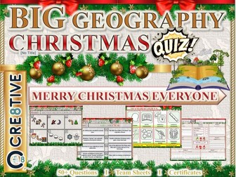
Geography Christmas Quiz – Christmas 50+ Questions for that perfect end of term subject based lesson. This Christmas quiz has a mixture of questions and rounds and skills. Some of the rounds will be subject based with subject based knowledge whilst others will be Christmas themed giving that perfect mix for an end of term Christmas lesson.
This resource will last a full 50 minutes to 1 hour.
This Geography resource contains:
1x PowerPoint with questions and answers
1x Student Answer Sheet double sided out of /54+ Marks
3 sets of Editable Team Certificates (1st place, 2nd place and 3rd place)
Skills reflection slide
Personal reflection questions
What does the Geography Christmas quiz comprise of?
Round 1:
Identify winter inspired images
Round 2:
True or False - good variety of themed questions
**Round 3: **
Matching and strategy can you find the correct links and eliminate all others
Round 4:
Linking Round - be able to make the correct links between left and right lists
Round 5:
Numbers Round -all the answers will involve numbers.
Round 6:
Jumbled up Round - Unravel these to find the answer staring directly back at you
Round 7:
Multiple Choice theory - Put your team to the test
Round 8:
Observation Round - Look at the image , remember everything you see….
Round 9:
Wordsearch Round - Locate the words before time runs out…
**Round 10: **
Tie Breaker - Design it but use all your team’s creative abilities
This will last a full hour for the full quiz by the time you get students into small teams and run through the quiz and the interactive way the answers appear. This informative, fun and engaging quiz will be a great way to celebrate the end of term and Christmas.
Search ‘Cre8tive Resources’ for support with our library of resources or send us an email.
Leave a review and email TheCre8tiveResources@gmail.com for a free resource as a thank you!!
Explore all our resources on TES
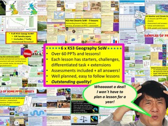
GET ALL OF MY PAID KS3 RESOURCES FOR JUST £12.99!!!
75+ lessons for under £13 or less than 10p a lesson… Bargain!
**Seven Key Stage 3 Schemes of work, enough teaching content for almost two years! **
All of my lessons are well planned, engaging, differentiated and fun! Download one of my free ones if you aren´t sure and try before you buy!
The following Schemes of work are included WITH assessments:
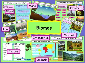
*** World biomes (11 lessons)**
• Lesson 1: Ecosystems
• Lesson 2: Food webs
• Lesson 3: Global biomes introduction
• Lesson 4: Mediterranean biome
• Lesson 5: Coral Reefs
• Lesson 6: Bamboo forests
• Lesson 7: Tropical Rainforests
• Lesson 8: Hot deserts
• Lesson 9: Polar biomes
• Lesson 10: Assessment lesson
• Lesson 11: Peer feedback/marking lesson
River landscapes of the UK (7 lessons)
• Lesson 1: Where are the UK’s rivers?
• Lesson 2: What are the UK’s rivers like?
• Lesson 3: What processes happen inside a river?
• Lesson 4: How do waterfalls form?
• Lesson 5: Meanders… they’re forever changing
• Lesson 6: The Landforms of the Lower Course
• Lesson 7: The Somerset levels floods 2014
• Lesson 8: How can we our manage rivers?
• Lesson 9: Rivers Assessment lesson
*** Weather and climate of the UK (9 lessons)***
• Lesson 1: What is weather and climate?
• Lesson 2: Recording the Weather
• Lesson 3: Who cares about the weather?
• Lesson 4: Where does the UK’s weather come from?
• Lesson 5: The Beast from the East
• Lesson 6: How can the UK use it’s wind?
• Lesson 7: Does the UK need so much rain?
• Lesson 8: What are Urban Micro climates and how do they affect London?
• Lesson 9: Assessment and feedback
Tropical Rainforests (12 lessons)
• Lesson 1: What and where are our rainforests?
• Lesson 2: What is the structure of the Rainforests?
• Lesson 3: What is the climate like in the Rainforest?
• Lesson 4: How are plants and animals adapted to the rainforest?
• Lesson 5: How do we benefit from the Rainforest?
• Lesson 6: What is Deforestation?
• Lesson 7: What are the effects of Deforestation?
• Lesson 8: How can we use the rainforest sustainably?
• Lesson 9: Saving the Rainforest!
• Lesson 10: Assessment lesson
• Lesson 11: Assessment feedback and peer marking lesson.
• Lesson 12: Extended project: Researching a rainforest.
*** UK landscapes and processes (7 lessons) **
• Lesson 1: introduction to UK landscapes
• Lesson 2: How does geology shape the UK?
• Lesson 3: Chemical weathering and limestone plateaus
• Lesson 4: Mountains in the UK: Their birth and erosion
• Lesson 5: Forests in the UK
• Lesson 6: Map reading and tourist developments in the lake district.
• Lesson 7: Assessment lesson with feedback PPT.
Hot deserts (9 lessons)
Lesson 1: What is a hot desert and where are they found?
Lesson 2: Drawing a climate graph for hot deserts
Lesson 3: How can animals and plants survive in hot deserts?
Lesson 4: What is desertification and why is it happening?
Lesson 5: Can desertification be stopped?
Lesson 6: Tourism in a hot desert far far away…
Lesson 7: Can you navigate through a hot desert?
Lesson 8: Assessment lesson
Lesson 9: Peer marking and assessment feedback
**Globalisation 12 lessons: **
Lesson 1: An introduction to globalisation
Lesson 2: How has globalisation happned?
Lesson 3: Why do companies go global? Mcdonalds
Lesson 4: What is a TNC and why do they work in so many countries?
Lesson 5: The pros and cons of globalisation
Lesson 6: The dark side of globalisation
Lesson 7: A TNC in Nigeria: Shell
Lesson 8: How is globalisation helpful? NGOs
Lesson 9: IGOs: WHO will stop Malaria?
Lesson 10: Assessment lesson
Lesson 11: Peer marking and assessment feedback
Lesson 12: Optional project on a TNC
extras!
This includes ALL of my lessons, quizzes, and six full schemes of work with over 75 lessons in total!!!
(some stand alone lessons are omitted as they are repeated/included in SoW)
Please check out all of my FREE school resources and Geography lessons on my shop where you´ll also find full schemes of work for just £3 and lots of other useful resources… Or purchase all of my KS3 resources for just £12.99!
I would really appreciate it if you could leave me a review, thanks!
https://www.tes.com/teaching-resources/shop/ukjoshkelly94
Questions or issues: ukjoshkelly@yahoo.co.uk
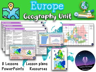
This Europe Geography Unit is a comprehensive and engaging teaching resource designed for Key Stage 2 children to explore various aspects of Europe, including famous landmarks, cultural similarities and differences, and the impact of human activity on the environment. The unit consists of eight lessons, each targeting specific learning objectives and accompanied by a range of interactive activities and discussions.
Lesson 1: Introduction to Europe
In this lesson, students are introduced to the continent of Europe and its diverse countries. They learn about the significance of Europe, its geographical features, and the countries that make up the continent.
Lesson 2: Exploring European Landmarks
Students delve into the fascinating world of famous landmarks in Europe, such as the Eiffel Tower, Colosseum, Big Ben, and more. They learn about the historical and cultural importance of these landmarks, their locations on a map of Europe, and engage in activities like landmark descriptions and map marking.
Lesson 3: Cultural Similarities and Differences
This lesson focuses on the cultural aspects of different European countries and compares them to the students’ local area. Students learn about traditions, customs, and languages, and engage in activities like creating travel brochure collages and group discussions about dream European holidays.
Lesson 4: Trade and Travel Connections
Students explore the trade and travel connections between Europe and their local area. They analyze import and export of goods, tourism, and transportation networks, and evaluate the impact of geographical factors on these connections.
Lesson 5: Planning a European Travel Adventure
In this lesson, students plan an imaginary travel adventure to visit multiple European landmarks. They research the landmarks, their locations, and plan an itinerary, considering factors like transportation, accommodations, local cuisine, and cultural experiences.
Lesson 6: Expressing Personal Views about European Locations
Students learn to express their opinions and preferences about specific European locations, providing clear reasons for their views. They engage in discussions and debates, considering factors like climate, landmarks, culture, or personal interests.
Lesson 7: Geographical Similarities and Differences
This lesson focuses on understanding geographical similarities and differences between Spain and the students’ local area. Students explore traditions, customs, languages, and analyze trade and travel connections, considering the impact of geographical factors.
Lesson 8: Graphing and Comparing Geographical Data
Students gather and analyze data related to temperature and rainfall in specific European locations. They create graphs to represent the data accurately and compare and interpret the data to draw conclusions about environmental conditions.
This resource provides a comprehensive and well-structured unit for teaching outstanding geography lessons about Europe to Key Stage 2 children. It incorporates a variety of interactive activities, discussions, and opportunities for reflection, promoting critical thinking and global awareness among students. The lessons are designed to engage and inspire students while fostering their understanding of landmarks and cultures. Also suitable for Key Stage 3.
KS2 LKS2 UKS2 KS3
A thorough revision quiz for Paper 1 of the new AQA GCSE Geography specification (9-1)
4 rounds:
a) The challenge of natural hazards
b) The living world
c) Physical landscapes in the UK
d) Case studies and examples
51 marks available. ANSWERS INCLUDED AFTER EACH ROUND.
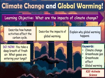
Perfect lesson resource for KS3 Chemistry! A fully differentiated and resourced lesson that assists students in learning about the impacts of climate change. Students will describe how human activities affect the carbon cycle, the impacts of global warming, and explain the greenhouse effect.
The resource includes a detailed and engaging lesson PowerPoint with differentiated activities, worksheet and quizzes for students to complete.
This resource is part of The Earth topic and has been created for the delivery of the Activate KS3 Science course. Also great for GCSE Science.
20 slides in total for the lesson PPT
Before you buy…
Get this lesson and 6 KS3 Geography Schemes of work for just £12.99 here! 60+ lessons!
https://www.tes.com/teaching-resource/all-of-my-ks3-resources-12842783
Or check out some of my other KS3 bundles:
3 x Biomes SoW (Deserts SoW, rainforests SoW global biomes Sow) for £6.99!
https://www.tes.com/teaching-resource/biomes-bundle-3x-ks3-geography-sow-deserts-rainforests-and-world-biomes-12974015
The lesson:
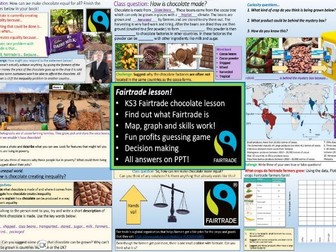
A very engaging, well planned and fun lesson about the inequality of chocolate and how Fairtrade can help to change this! Absolutely perfect for Fairtrade week! The lesson is very well structured and easy to teach for non-specialists too.
**The lesson investigates: **
How is chocolate made
Where is chocolate grown
Why Chocolate can create inequality
What is fairtrade and how does it work?
**Activities include: **
Graph skills (sheet included)
Map skills (writing frames on PPT)
thinking and discussion
Numeracy (fun profit division activity!)
Literacy (written and oral)
photo analysis
One optional mapping activity requires atlases.
Grab a bargain! Please leave a review : )
Please check out all of my FREE school resources and Geography lessons on my shop where you´ll also find full schemes of work for just £3 and lots of other useful resources… Or purchase all of my resources for just £12.99!
I would really appreciate it if you could leave me a review, thanks!
https://www.tes.com/teaching-resources/shop/ukjoshkelly94
Questions or issues: ukjoshkelly@yahoo.co.uk
7 fully resourced lessons suitable for KS3 Geography. A wide range of activities included e.g. crosswords, odd one out tasks, exam questions, worksheets etc. Main activities are differentiated.
Lessons include:
What is weather and climate?
How do we measure weather?
How can weather data be presented?
What are clouds and why does it rain?
What are depressions and anticyclones?
What is the climate of the UK?
How does climate vary across the world?
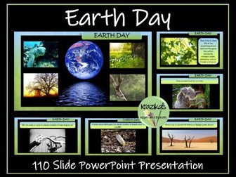
This resource contains an informative and fully editable 110-slide PowerPoint presentation on Earth Day. The presentation focuses on:
This is a fully editable and informative, 100-slide PowerPoint presentation on Earth Day. The presentation focuses on:
the history of earth day
the aims of Earth Day
environmental issues
Earth Day projects
The Earth Day 2024 theme - ‘Planet v Plastics’
How we can help to look after our wonderful planet earth
The PowerPoint also contains links to a breathtaking, 4-minute video of our planet and a link to a moving ‘Earth Song’.
Please note, the watermark on the preview images are not present on the resources themselves.
If you buy this resource and are pleased with your purchase, I would be extremely grateful if you could leave a review. As a token of appreciation, you can have a free resource of your choice up to the same value as your purchased resource. Just email inspireandeducate@aol.co.uk with your user name, the resource you have reviewed and the resource you would like for free.
A simple text version of this presentation, more appropriate for younger / SEN pupils, is also available:
Earth Day Simple Text Presentation
You may also be interested in:
Earth Day Puzzle Pack
This resource contains 10 differentiated word searches, anagram puzzles and crosswords.
Great Thunberg Presentation
Climate Change Presentation
Thinking of publishing your own resources or already an author and want to improve your resources and sales? Check out this step-by-step guide:
How to Become a Successful TES Author: Step-by-Step Guide
This clear, detailed and visually-appealing resource offers a complete reference point for students revising knowledge relating to climate change. It contains comprehensive sections on:
-Overview and Key Ideas;
-Causes of Climate Change;
-Effects of Climate Change;
-Addressing Climate Change;
-Key Vocabulary;
-Timeline of Climate Change.
The resource is ideally suited for students in upper KS2 or lower KS3.
The resource is designed to be printed onto A3 or A4, and is provided as both a PDF and a Word version (so that you can edit if you want to). All images used are licensed for commercial use.
Have any issues with this resource or a request? Contact us directly for the quickest response at: explore_education@outlook.com
A lesson about longitude and latitude for geography. All resources provided. This lesson has been successfully used for a lesson observation and includes an interactive PowerPoint, worksheets, resources, planning and video song.
L.O. To learn to identify the position and significance of the lines of Latitude, Longitude, Tropic of Cancer, Capricorn and Equator.
Success Criteria:
I can differentiate between weather and climate.
I can label lines of Latitude, Longitude and the Tropics.
I can explain what the lines are used for and their direction.
I can create sentences about countries using the lines to describe their whereabouts.
Resources Included:
PowerPoint
Lesson Plan
Starter Task Worksheet
World Map Activity
Coordinates for main activity
Writing task
Success Criteria Strip
Longitude and latitiude song video
Extension task
WAGOLL Example Map
Sentence starters for LA
Word bank
Tags: ks2 ks3 y3 y4 y5 y6 humanities atlas map mapping weather climate nqt ect interview Climate change Travel and tourism What is Geography Structure of the earth year 3 year 4 year 5 year 6 longitude and latitude ks2 worksheet ppt finder google maps calculator meaning london games tes activity song display teaching latitude and longitude topic
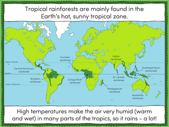
This lesson is part of Tropical Rainforests, a Geography unit designed for students in KS2, but can also be taught as a stand alone lesson. All resources are compatible with both Microsoft Office and Google Workspace.
The presentation introduces students to tropical rainforests, including some of the flora and fauna that live in them. Students then learn about the Earth’s tropical belt and the location of the various rainforests within it.
The activity challenges students to label features of a world map including the Equator, the Tropic of Cancer and the Tropic of Capricorn. Students then locate 8 of the world’s tropical rainforests.
Easier - Students use a prompt map and have activity clues.
Harder - Students use a prompt map but have no activity clues.
Extension - Students fill in the missing words in a paragraph about tropical rainforests.
If you like this resource, we would appreciate a review! We will happily send you a free resource in return for a review or useful suggestions/feedback. Contact us at ed@teachitforward.co.uk.
This interesting and highly-stimulating lesson enables students to describe and understand the key aspects of physical geography (e.g. climates, vegetation belts, flora, fauna, mountains, and rivers) and human geography (e.g. types of settlement, populations, use of resources, and trade) in the vast and varied continent of Africa. Whilst gaining a wide range of knowledge about the content, students also become familiar with a wide range of vocabulary pertinent to the geography curriculum.
The lesson follows a clear, logical, bite-size learning journey, which guides students towards relevant and constructive learning objectives. Over the course of this journey, they become able to:
Identify Africa on a map, and identify the countries and regions within the continent;
Understand key information about the physical and human geography of the continent, through a fun, interactive quiz;
Retrieve, share, and describe their understanding of the physical and human geography of specific locations in Africa (Sahara Desert, Cape Town, The African Savanna and the Mount Kilimanjaro) through a jigsaw model task;
Complete a case study of the physical and human geography of their own place in Africa, and describe their findings to others;
-Peer assess each others’ descriptions using the learning objectives.
This resource pack includes:
A visually engaging whole-lesson PowerPoint presentation;
Key case-study information sheets on the Sahara Desert, Cape Town, the African Savanna and Mount Kilimanjaro (in both PDF and Word - inside the zip-folder);
A blank case study template.
All images are licensed for commercial use. Note: The final task works best with access to ICT/internet resources.
This resources within this lesson can be easily adapted to suit home/remote learning.
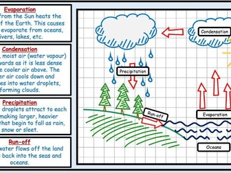
A powerpoint that describes the principles of the Water Cycle, covering evaporation, condensation, precipitation, surface runoff, transpiration,infiltration, percolation and groundwater discharge. The powerpoint is supported by an extended writing sheet for more able students and a differentiated worksheet for students with learning difficulties, in order to assess understanding of the concepts studied.
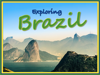
Exploring Brazil is a Geography unit designed for students in KS2 (Y4-6).
The planning overview, topic title page and vocabulary page can be downloaded for free here. Lessons include:
L1 – Identifying the countries and capitals of South America
L2 – Writing a Brazil fact file
L3 – Using 4 and 6-figure grid references to locate Brazilian cities
L4 – Identifying the human and physical features of Brazil
L5 – Exploring Brazil’s ecosystems
L6 – Investigating Brazil’s weather and climate
Each lesson includes a presentation and differentiated activities/worksheets.
If you like this resource, we would appreciate a review! We will happily send you a free resource in return for a review or useful suggestions/feedback. Contact us at ed@teachitforward.co.uk.
2 lessons: measuring the weather, climate zones, factors affecting climate. Instructions for making a wind sock to use outside and calculating sunshine hours (to cover Numeracy framework). Couple of references to Wales (to cover Curriculum Cymreig)
This activity teaches the pupils first to read a climate graph and then to make one. It concentrates on climate data for the UK and for an extension activity, the pupils have to compare the climates of London and Edinburgh.
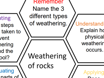
Retrieval practice for the topic Weathering of Rocks in Year 6 Geography. A great end of topic task to help consolidate and stretch their knowledge of the topic. Using Bloom’s taxonomy children move through the different levels of questioning to help deepen their understanding of the topic. Using the hexagon style also helps them to realise the link between all the questions and that it is all related.
 Quick View