I've worked in primary teaching for over 10 years and specialise in creating fun and engaging educational resources, particularly for Geography and History.
I've worked in primary teaching for over 10 years and specialise in creating fun and engaging educational resources, particularly for Geography and History.
This lesson is part of a wider cross-curricula unit called London Zoo which is designed for KS1 and lower KS2 students (Y2-4).
The presentation first introduces students to grid references. It then challenges them to give grid references for animals on a map of London Zoo.
In the activity, students are challenged to describe the position of animals at London Zoo using grid references. It is differentiated two ways:
Easier – Students have six colour coded questions so they can locate animals easily.
Harder – Students have to find the animals themselves.
Extention – Students find the grid references of other locations at the zoo (e.g. the gift shop).
If you like this resource, we would appreciate a review! We will happily send you a free resource in return for a review or useful suggestions/feedback. Contact us at ed@teachitforward.co.uk.
This lesson is part of a wider cross-curricula unit called London Zoo which is designed for KS1 and lower KS2 students (Y2-4).
The engaging presentation first introduces students to compass directions. It then challenges them to describe the location of animals at London Zoo using north, east, south and west.
In the activity, students describe the position of animals at London Zoo using compass directions. It is differentiated two ways:
Easier – Students have colour coded questions so they can locate animals quickly.
Harder – Students have to find the animals themselves.
Extension – Students are challenged to state the position of animals in relation to other animals (e.g. The owls are north of the gibbons).
If you like this resource, we would appreciate a review! We will happily send you a free resource in return for a review or useful suggestions/feedback. Contact us at ed@teachitforward.co.uk.
This lesson is part of a wider Geography unit called Great Missenden – A Village Settlement which is designed for students in upper KS2 (Y4-6).
This lesson is the last in the unit and is ideally done after the fifth lesson – Surveying Great Missenden High Street using Google Street View.
The presentation briefly outlines the RICEPOTS system for categorising land use. It then introduces students to a survey map showing land use in Great Missenden High Street.
The activity challenges students to interpret information from the survey. In the extension activity students complete a bar chart showing land use on Great Missenden High Street.
If you like this resource, we would appreciate a review! We will happily send you a free resource in return for a review or useful suggestions/feedback. Contact us at ed@teachitforward.co.uk.
This lesson is part of a wider Geography unit called Great Missenden – A Village Settlement which is designed for students in upper KS2 (Y4-6).
First the presentation introduces students to satellite photos. It then challenges them to use their detective skills to identify various human and physical geographical features in and around Great Missenden.
In the writing activity, students try to identify features in satellite photos of Great Missenden, explaining the reasoning behind their ideas. It is differentiated three ways:
Easier – Student identify one feature in each satellite photo.
Medium – Student identify two features in each satellite photo.
Harder – Student identify three features in each satellite photo.
Extension - Students sort the features they have found in the satellite photos into human and physical geographical features.
If you like this resource, we would appreciate a review! We will happily send you a free resource in return for a review or useful suggestions/feedback. Contact us at ed@teachitforward.co.uk.
This lesson is part of a wider Geography unit called Great Missenden – A Village Settlement which is designed for students in upper KS2 (Y4-6).
First the presentation reminds students how to find grid references. It then challenges them to locate various geographical features in Great Missenden using 4-figure grid references.
In the activity, children locate features of Great Missenden using grid-references. It is differentiated three ways:
Easier – Students locate features of Great Missenden using 4-figure grid references (with clues).
Medium – Students locate features of Great Missenden using 4-figure grid references (no clues).
Harder – Students locate features of Great Missenden using 6-figure grid references.
Extension – Students complete sentences using compass directions to describe the location of features of Great Missenden in relation to each other.
If you like this resource, we would appreciate a review! We will happily send you a free resource in return for a review or useful suggestions/feedback. Contact us at ed@teachitforward.co.uk.
This lesson is part of a wider cross-curricula unit called London Zoo which is designed for KS1 and lower KS2 students (Y2-4).
The presentation first locates London Zoo within the UK and London itself. Students then find out a variety of interesting facts about the zoo.
The activity challenges students to write a fact file about London Zoo. It is differentiated four ways:
Easier – Students write cloze procedure sentences (one word per sentence)
Medium – Students write cloze procedure sentences (students write whole sentences)
Harder – Students write their own London Zoo fact file (using a sentence starter and vocabulary prompt)
Hardest – Students write their own London Zoo fact file (using just a vocabulary prompt)
If you like this resource, we would appreciate a review! We will happily send you a free resource in return for a review or useful suggestions/feedback. Contact us at ed@teachitforward.co.uk.
This lesson is part of a wider Geography unit called Great Missenden – A Village Settlement which is designed for students in upper KS2 (Y4-6).
In this lesson, students are introduced a high street survey, a great way of looking at land use in settlements. The presentation first outlines the RICEPOTS system for categorising land use and includes many photos of real world examples to aid understanding.
The activity challenges students to use Google Street View to work out the types of land use on Great Missenden High Street. It is differentiated three ways:
Easier – Students find the business name/land use of 10 places on Great Missenden High Street (with clues).
Medium – Students find the business name/land use of 14 places on Great Missenden High Street (with clues).
Harder – Students find the business name/land use of 14 places on Great Missenden High Street (no clues).
Extension – Students use Google Street View to survey a section of Great Missenden High Street by themselves.
If you like this resource, we would appreciate a review! We will happily send you a free resource in return for a review or useful suggestions/feedback. Contact us at ed@teachitforward.co.uk.
This set of resources is designed for teaching the KS2 Stone Age History unit. It includes an engaging presentation, differentiated worksheets and stickers. The activity helps children categorise foods into those ‘hunted’ and those ‘gathered’. This reinforces the idea that Stone Age humans were primarily ‘hunter-gatherers’.
There are three differentiated worksheets:
- one with vocabulary for less able children
- one with fill-in-the-blank sentences using commas in lists
- one which extends more able children by asking them to explain how Stone Age humans hunted
The stickers will print out on Avery address labels (21 per page).
If you like this resource, we would appreciate a review! We will happily send you a free resource in return for a review or useful suggestions/feedback. Contact us at ed@teachitforward.co.uk.
This lesson is part of a wider unit called Exploring St Lucia and is designed to teach KS2 students about a contrasting non-European country.
It first introduces St Lucia and the wider Caribbean area, helping students to locate the island within the wider world.
The activity then challenges students to identify St Lucia and other islands in the Caribbean. It is differentiated three ways:
Easier – Students identify 8 countries (with first-letter clues).
Medium – Students identify 10 countries and 3 seas/oceans (with first-letter clues).
Harder – Students identify 10 countries and 3 seas/oceans (no clues).
Extension – Students complete a cloze procedure text about the location of St Lucia.
If you like this resource, we would appreciate a review! We will happily send you a free resource in return for a review or useful suggestions/feedback. Contact us at ed@teachitforward.co.uk.
This lesson is part of a wider unit called Exploring St Lucia and is designed to teach KS2 students about a contrasting non-European country.
It first introduces students to the tropical climate zone and its associated weather (i.e. high temperatures, high rainfall, dry and wet seasons) and compares this with temperate climates such as that of the UK.
Students are then encouraged to interpret data from a climate graph for St Lucia. Finally, other aspects of a tropical climate are covered including tropical storms and hurricanes.
The accompanying true or false activity helps children to recap what they have learned about the climates of St Lucia and the UK. It is differentiated two ways:
Easier – Students have 6 true or false statements.
Harder – Students have 10 true or false statements.
Extension – Students complete a cloze procedure text about St Lucia’s weather and climate.
If you like this resource, we would appreciate a review! We will happily send you a free resource in return for a review or useful suggestions/feedback. Contact us at ed@teachitforward.co.uk.
This lesson is part of a wider unit called Exploring St Lucia and is designed to teach KS2 students about a contrasting non-European country.
This lesson looks at similarities and differences between St Lucia and the UK including:
– location in the world
– population
– languages
– currency
– heads of state
– physical geography
– types of employment
In the partner activity students sort statements about the countries into two groups – those describing St Lucia and those describing the UK. It is differentiated two ways:
Easier – Students sort statements about St Lucia and the UK (using stickers and a worksheet).
Harder – Students sort statements about St Lucia and the UK (completed in an exercise book).
Extension – Students think of similarities & differences between St Lucia and the UK.
If you like this resource, we would appreciate a review! We will happily send you a free resource in return for a review or useful suggestions/feedback. Contact us at ed@teachitforward.co.uk.
This lesson is part of a wider unit called Exploring St Lucia and is designed to teach KS2 students about a contrasting non-European country.
The presentation explores the main geographical features of St Lucia and asks students to categorise these into human and physical.
The activity then challenges students to identify these features on a map of St Lucia. It is differentiated three ways:
Easier – Students identify human & physical features of St Lucia (with clues)
Medium – Students identify human & physical features of St Lucia (no clues)
Harder – Students identify human & physical features of St Lucia (no clues and students also have to draw arrows)
If you like this resource, we would appreciate a review! We will happily send you a free resource in return for a review or useful suggestions/feedback. Contact us at ed@teachitforward.co.uk.
This lesson is part of a wider unit called Exploring St Lucia and is designed to teach KS2 students about a contrasting non-European country.
The presentation introduces the students to satellite photos. It then challenges them to use their detective skills to identify the various human and physical geographical features of St Lucia.
It is accompanied by a writing-based activity which challenges students to identify the features in the satellite photos and explain their reasoning. It is differentiated three ways:
Easier – Students identify 1 feature per satellite photo.
Medium – Students identify 2 features per satellite photo.
Harder – Students identify 3 features per satellite photo.
Extension – Students sort the features they have found into human and physical.
If you like this resource, we would appreciate a review! We will happily send you a free resource in return for a review or useful suggestions/feedback. Contact us at ed@teachitforward.co.uk.
This lesson is part of a wider unit called Exploring St Lucia and is designed to teach KS2 students about a contrasting non-European country.
First the presentation introduces students to the directions of the compass. It then helps them to locate places in St Lucia using compass directions – first using the four cardinal points (N, E, S, W), then also using the four ordinal points (NE, SE, SW, NW).
The accompanying activity gives students a chance to locate places in St Lucia using the points of the compass. It is differentiated two ways.
Easier – Students locate places using the eight points of the compass (with compass direction hints).
Harder – Students locate places using the eight points of the compass (no compass direction hints).
Extension – Students complete another compass direction challenge.
If you like this resource, we would appreciate a review! We will happily send you a free resource in return for a review or useful suggestions/feedback. Contact us at ed@teachitforward.co.uk.
This lesson is designed for KS2 students. It can be taught as a stand alone lesson but is also available as part of two wider units, both of which are available on TES:
-Volcanoes
-Volcanoes & Earthquakes
First the presentation introduces some of the world’s most famous volcanoes and classes them as active, dormant or extinct.
The activity then challenges students to locate volcanoes using an atlas or the internet (e.g. Google maps). Alternatively, a map of famous world volcanoes is also provided.
Easier – Students locate volcanoes using the map of famous volcanoes (writing numbers).
Medium – Students locate volcanoes using the map of famous volcanoes (writing volcano names).
Harder – Students locate volcanoes using an atlas.
(N.B. It is recommended you check the atlas has the relevant maps prior doing the activity.)
If you like this resource, we would appreciate a review! We will happily send you a free resource in return for a review or useful suggestions/feedback. Contact us at ed@teachitforward.co.uk.
This lesson is part of Investigating Rivers, a unit designed for upper KS2 (Y4-6).
The presentation takes students on a journey from the source to the mouth of the River Thames. Starting at Thames Head, the source of the River Thames, students investigate maps and satellite photos and try to identify river features along the way. Other locations include Windsor Castle, the Isle of Dogs in London and the mouth of the river at Southend-on-Sea.
The writing-based activity challenges students to first label each map/satellite photo and then write a paragraph describing the location and river features they can see. It is differentiated two ways:
Easier – Students have maps/satellite photos and cloze procedure paragraphs to complete.
Harder – Students have maps/satellite photos, a wordbank and write their own paragraphs.
If you like this resource, we would appreciate a review! We will happily send you a free resource in return for a review or useful suggestions/feedback. Contact us at ed@teachitforward.co.uk.
This is the first lesson in Mountain Environments, a Geography unit designed for students in upper KS2 (Y4-6).
First the presentation introduces students to the topic and looks at some of the activities people do in mountains. It then introduces the key features of a mountain range.
The activity challenges students to identify the key features of a mountain environment. It is differentiated three ways:
Easier – Students identify 8 key features of mountains.
Medium – Students identify 10 key features of mountains.
Harder – Students label the key features of mountains in their exercise book.
Extension – Students match mountain vocabulary to their definitions.
If you like this resource, we would appreciate a review! We will happily send you a free resource in return for a review or useful suggestions/feedback. Contact us at ed@teachitforward.co.uk.
This lesson is designed for KS2 children. It can be taught as a stand alone lesson but is also available as part of two wider units, both of which are available on TES:
-Earthquakes
-Volcanoes & Earthquakes
First the presentation looks at how the Earth’s crust is split into tectonic plates. It then examines the causes of earthquakes, how they occur at the fault lines between tectonic plates and what the hypocentre and epicentre of an earthquake are.
There are three different activities to choose from which can be done in Geography and/or Literacy lessons. These include:
Quiz Activity
Students watch a video clip about earthquakes and answer comprehension questions about it. This is differentiated two ways.
Cloze Procedure Activity
Students fill in the blanks in an explanation text about earthquakes. This is differentiated two ways.
Writing Activity
Student write an explanation text about earthquakes. This is differentiated three ways and comes with vocabulary and sentence starter prompts.
If you like this resource, we would appreciate a review! We will happily send you a free resource in return for a review or useful suggestions/feedback. Contact us at ed@teachitforward.co.uk.
This resource is designed for teaching the Great Fire of London KS1 History unit. You can download the planning for free here. It is suitable for Year 2 children and more able Year 1 children.
The presentation introduces the context of the Great Fire of London and challenges children to find reasons for the rapid spread of the fire. The literacy-based activity reinforces this learning .
Two differentiated worksheets challenge children to match reasons for the Great Fire of London with sentence starters:
- the standard activity sheet gives five possible reasons
- an easier activity sheet gives just two reasons to choose from per sentence starter
If you like this resource, we would appreciate a review! We will happily send you a free resource in return for a review or useful suggestions/feedback. Contact us at ed@teachitforward.co.uk.
This lesson is designed for KS2 students. It can be taught as a stand alone lesson but is also available as part of three wider units, all of which are available on TES:
-Volcanoes
-Earthquakes
-Volcanoes & Earthquakes
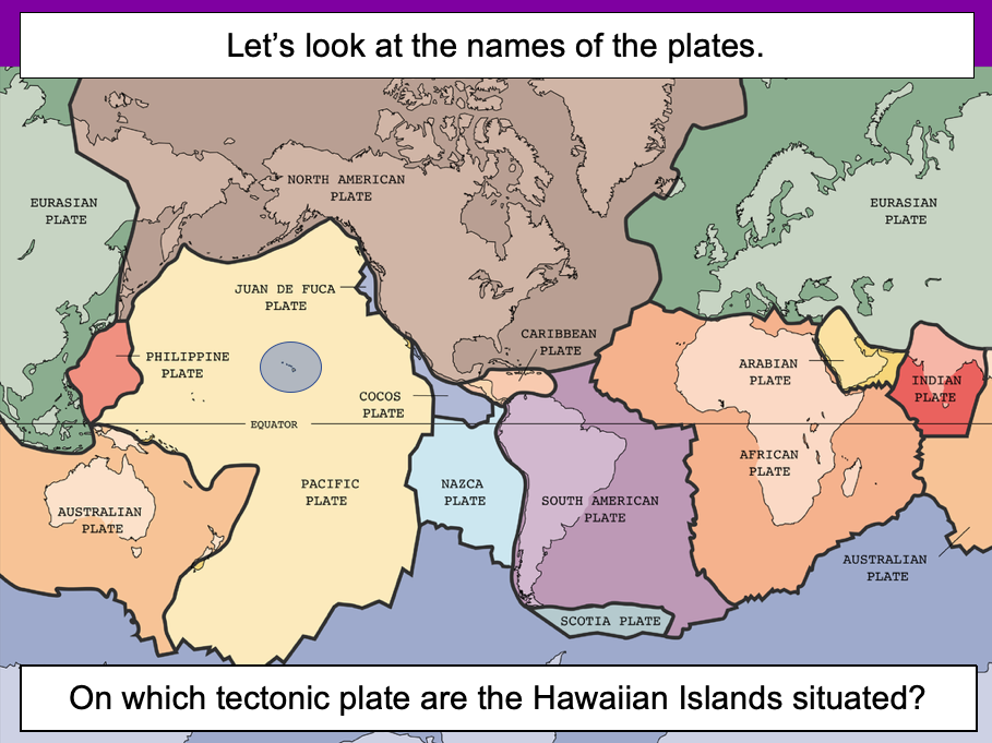
The presentation introduces the idea that the world’s crust is split into tectonic plates and looks at how these are related to volcanoes and earthquakes.
The activity challenges students to identify tectonic plates using a map. It is differentiated two ways:
Easier – Students identify the world’s tectonic plates using a colour-coordinated map.
Harder – Students identify the world’s tectonic plates using a plain map.
Extension – Students use an atlas to find out which tectonic plate countries of the world are located on.
If you like this resource, we would appreciate a review! We will happily send you a free resource in return for a review or useful suggestions/feedback. Contact us at ed@teachitforward.co.uk.