Double-sided A3 revision sheet for Coasts. Includes questions on physical processes, landform recap with key prompt question and other questions on the back of sheet (including an exam question with a figure).
A3 sheet with detailed ideas about how to respond to the threat of earthquakes in Haiti. Students have $20 billion to spend using the costed ideas and must justify it in the boxes.
Lesson covering 4 figure grid references. Includes:
Do Now worksheet
Grid reference explanation and the 2 golden rules
Pacman activity to help students remember
Main activity
Plenary
Complete lesson covering the ways IGOs (intergovernmental organisations) manage the environment through treaties and conventions. Lesson covers 6 key IGO management schemes including the Montreal Protocol on the ozone layer, CITES, the UN Convention on the Law of the Sea, the Helsinki Water Convention, the Antarctic Treaty System and Millennium Ecosystem Assessment. Lesson includes:
Printable table for students to complete through the lesson
Video and article summarising the Montreal Protocol that students use to complete their table
Series of information sheets on the other 5 conventions (with an accompanying news article for each one) that students use to complete the rest of their table
Speed dating sheet for students to question their partners in order to check for understanding
Possible 20 mark exam question and printable planning sheet
Complete lesson covering the different ways that countries try to limit globalisation, with a focus on censorship, migration and trade protectionism. Lesson was designed for the Edexcel A-level geography Globalisation topic, but would be suitable for other specifications and schemes of work. Lesson includes:
Do Now
Shared partner work - how can countries promote or limit globalisation?
Keywords
Comprehension questions using a printable handout on ways that countries limit globalisation
AfL activity to check for understanding - could be verbal or written
Plenary - ranking activity
Complete lesson covering foreign ownership and the influence of this on national identity in the UK. Lesson was designed for the Migration, Identity & Sovereignty topic in the Edexcel A-level, and includes:
Recap Do Now
Explanation of why ‘Made in Britain’ is increasingly complex
Students use printable info sheets to categorise the pros & cons of foreign ownership
Explanation of foreign ownership of property in London & the impact of this on identity
Printable handout with reading about Qatari ownership the growth of Indian TNCs like Tata, with accompanying questions
6 mark exam question and model answer
Complete lesson covering global borrowing and trade policies, with a focus on structural adjustment programmes (SAPs) led by the IMF and HIPC policies to reduce debt. Exemplified with Jamaica’s structural adjustment programme and its impacts. Lesson includes:
Do Now
Explanatory diagram showing how SAPs and IMF loans work
Benefits of SAPs and IMF support for emerging economies
Printable worksheet - advantages & disadvantages of SAPs match-up activity
Explanation of HIPC policies
Video and article on Jamaica’s structural adjustment programme, with comprehension questions
Plenary
44 mark end of topic test for the Global Development topic, with all questions in the format of the actual GCSE for Edexcel A. Includes a mixture of short answer questions, skills & mathematical questions and an 8 mark question at the end. A resource sheet that can be printed and mark scheme is also included. Ideal for use at the end of this topic.
34 mark end of topic test for the UK landscapes and rivers topic, with all questions in the format of the actual GCSE for Edexcel A. Includes a mixture of short answer questions, skills & mathematical questions and an 8 mark question at the end. A resource sheet that can be printed and mark scheme is also included. Ideal for use at the end of this topic.
34 mark end of topic test for the Physical Fieldwork topic, with all questions in the format of the actual GCSE for Edexcel A. Includes a mixture of short answer questions, skills & mathematical questions and an 8 mark question at the end. A resource sheet that can be printed and mark scheme is also included. Ideal for use at the end of this topic.
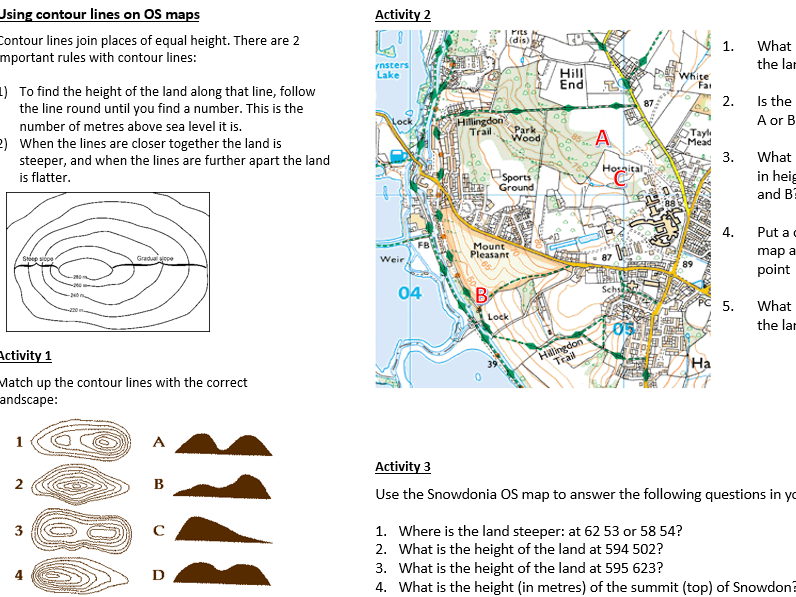
KS3 lesson covering height and contour lines. Includes:
Do Now activity
Explanation of relief and altitude
Explanation of the 3 ways of showing height on maps
Contour line explanation
Main activity worksheet
Quiz and plenary
Complete lesson covering the causes and impacts of suburbanisation and counter-urbanisation. Lesson includes:
Do Now
Graph and discussion
Mind map reasons for suburbanisation
Explanation of counter-urbanisation
Printable sheet that students use to categorise the impacts of suburbanisation and counter-urbanisation
Plenary
Complete lesson covering OS map symbols. Lesson includes:
Do Now labelling activity using a printable OS map
Recap on other types of maps
Labelling activity with printable OS map symbols sheet
OS map symbols bingo to check understanding
Plenary - describe a route on an OS map using the symbols
Complete lesson covering the different types of rain. Lesson includes:
Do Now - interpreting a rainfall map
Video
Explanation of the different types of rain
Printable worksheet for students to complete using diagrams and keywords on the board
AfL activity
Explanation of types of rainfall in different global locations
Plenary to check for understanding
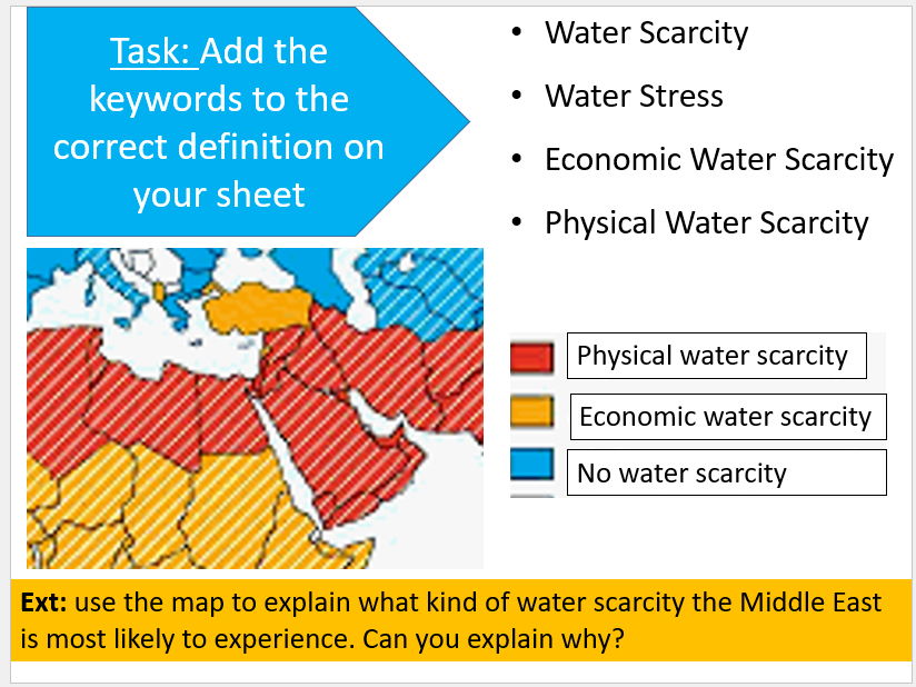
Complete lesson covering water conflict and water scarcity in the Middle East, with a focus on the Jordan River. Lesson includes:
Do Now - locating the Jordan River
Comparison of precipitation between Jordan and the UK
Keyword match-up activity and extension
Link to Water Scarcity Atlas for discussion
Video
Annotate and complete the sentences on the map of the Jordan River - printable handout
Plenary
Bonus video and questions
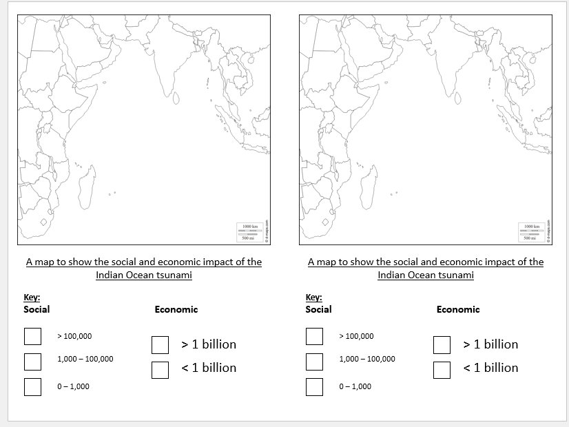
Complete lesson covering the 2004 Boxing Day tsunami in the Indian Ocean. Lesson includes:
Do Now
Video and questions
Printable maps and data to create a choropleth map to help students decide which country was worst hit
Decision making activity with 2 options to prevent future tsunamis (printable sheet)
Plenary
Lesson covering V-shaped valleys. Designed for KS3 but could be used for KS4. Includes:
Do Now activity
Diagrams showing the formation of a v-shaped valley
Explanation of lateral and vertical erosion
Main activity drawing and labelling the diagram
OS map activity with a v-shaped valley
Plenary
Complete lesson covering the causes of flooding in Bangladesh. Designed for KS3 but could be used for KS4. Lesson includes:
Do Now
Explanation of Bangladesh’s vulnerability
Information cards and questions
Extension activity on monsoons
AfL activity and bingo activity to check understanding
Plenary - correct the mistakes
Complete lesson covering the formation of coves and concordant coastlines. Lesson includes:
Do Now
AfL activity - concordant vs discordant
Animated explanation of the formation of a cove
Gap fill activity
Whole class AfL activity to check understanding
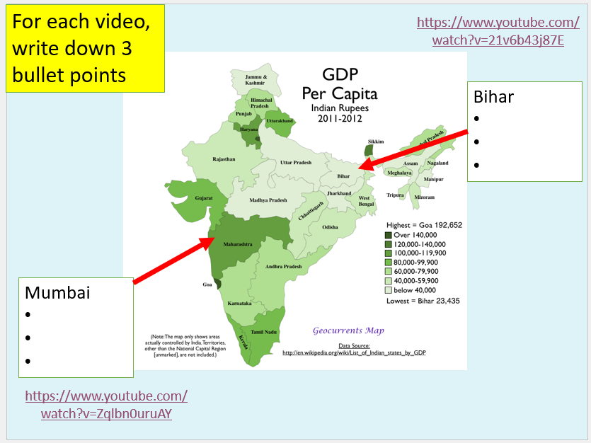
Complete lesson covering uneven development within India. Lesson includes:
Do Now - interpreting map task
Breakdown of GDP in different Indian states and tasks
2 videos and students use to note down key differences
Printable reading on 2 areas of India and comprehension questions
3 mark exam question and model answer