 Quick View
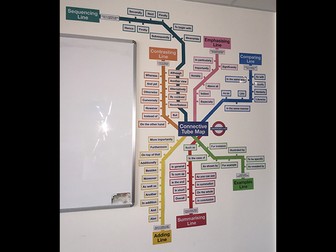
Conjunctions Tube Map Display
Everything you need to create a display to remind students to use conjunctions in their writing. Designed in the style of a London Underground or tube map, each line of the map represents a different conjunction group with the stations represented by the conjunctions themselves, all colour coded. Note that the title in the middle will say ‘Conjunction Tube Map’ (not ‘Connective’). Simply print, laminate, cut and put up your display. It can be organised in whatever way you choose, but an image is supplied as a guide or suggestion. Hope you find it useful!