A 25 Slide PowerPoint all about the ways in which we can care and look after our Environment. It explains what the environment it as the importance of Recycling, Throwing away Rubbish, Saving Water, Saving Trees and Looking after Animals. It includes a video on recycling paper. All supported by Widget Symbols.
Includes 15 images to cut out and stick on a grid with basic coordinates (A1- E5) for higher abilities and A1- C5 for lower and middle abilities. Maps look best when printed on A3 paper. Images can be printed either A4 or A3.
Higher abilities can draw their own island, then select and stick on the images of the places that they want on their island. There is also a worksheet for students to then find and write the coordinates of each image.
Higher ability students could be encouraged to look for their own images and create their own island, or to create a map of the school or of their route to school, or their village/town.
This is a booklet about maps / basic direction skills to be used for your SEN or lower ability pupils alongside a Geography topic you may have involving maps.
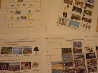
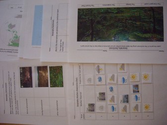
6 week weather chart suitable for SEN, Early Years, Preschoolers, Primary.
Use the chart (print in A3) to record the weather for 6 weeks in your local area, or use the 2nd chart to compare 2 places or countries.
Includes 2 question worksheets for higher abilities, 1 being a recap and summary worksheet of their findings comparing 2 places/countries.
For lower and middle ability- includes pictures of sunshine, clouds, snow, rain, storm, fog, frost, rainbow, and wind to help with understanding. Allows them to observe the days weather and think about what the weather will be like next week, making predictions.
For higher ability- space to write the weather they can see and allows them to predict what they think the weather will be next week. Children could also take their own photos of the weather and stick them on the chart. A clip from BBC weather showing the latest weather forecast could be shown during the lesson, and children could be encouraged to look at different areas of the UK or another country to compare the weather in different regions. Use the 2 worksheets to compare understanding before carrying out the observations and after to check learning and understanding.
Good starting point to exploring the water cycle.
A PowerPoint that explains all about Volcanoes and Mount Vesuviuhs. It includes instructions of how to make your own volcano. All supported by Widgit Symbols.
My aim was to bring in a bit of my modern foreign languages background when teaching my special education class. It is Autism friendly - as there is a clear sequence/structure and lots of visual support. The idea is to ‘visit’ countries around the world, learning facts - using English skills for reading, comprehension and writing; learn some simple language, and sample the culture. This is a bundle of all the European countries including passport & board pass templates, sensory ideas, and other general resources and then it includes the following countries:
China, Japan, India, Thailand, Russia, Indonesia, Pakistan, Philippines & Vietnam.
If you’re not sure, check out my example lesson in France and if you like this, check out my other bundle of European countries.
My aim was to bring in a bit of my modern foreign languages background when teaching my special education class. It is Autism friendly - as there is a clear sequence/structure and lots of visual support. The idea is to ‘visit’ countries around the world, learning facts - using English skills for reading, comprehension and writing; learn some simple language, and sample the culture. This is a bundle of all the European countries including passport & board pass templates, sensory ideas, and other general resources and then it includes the following countries:
France, Germany, Spain, Italy, Sweden, Greece, Poland, Scotland & Turkey. If you’re not sure, check out my France resource to give you a feel, and if you really like it, check out my Asia bundle.
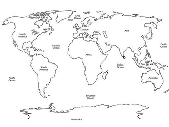
Worksheets to help with a basic introduction to the oceans and the continents of the world.
Teach people the names and positions of the oceans and the continents with the help of these cut out and stick worksheets. Test knowledge with a worksheet to fill in and colour the world map in.
Helps with basic geography, maps can be used to name cities and places around the world.
Literacy Games and Christmas Fun Pack
A fantastic collection of fun and educational literacy resources, including:
* Literacy Bingo
* Literacy True or False
* Christmas Quiz
* Christmas Fun Pack
Click on the links for further details.
A great value download.
For more great resources and lessons, visit my page here:
https://www.tes.com/teaching-resources/shop/EngageinEnglish
The Fun with Words Collection
A collection of fun and engaging literacy resources, complete lessons and activities. Fantastic value for money download and a real time saver.
See the links for further details.
Visit my shop for more great lessons and resources:
https://www.tes.com/teaching-resources/shop/EngageinEnglish
(Credits: cooltext.com, copyright free image: https://pixabay.com/en/book-old-clouds-tree-birds-bank-863418/
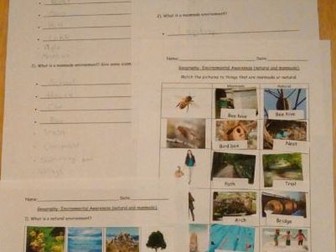
3 differentiated worksheets for natural and manmade environments, plus another to check learning.
lower abilities- uses photos and labels to cut out and stick.
middle abilities- uses labels to copy or cut out and stick.
higher abilities- allows students to write their own ideas.
The last worksheet uses photos, and/or labels to copy or cut out and stick to demonstrate student's understanding and learning. This worksheet can be used for all abilities, with higher levels being encouraged to use magazines or go on the computer to find their own examples as extension work.
Maps and coordinates, Environmental Awareness (natural and manmade) Weather Chart (prediction, observation and comparing 2 different areas or regions).], Rainforest labelling and matching descriptions.
Geography Environmental Awareness (natural and manmade)
3 differentiated worksheets for natural and manmade environments, plus another to check learning.
Geography- map and coordinates.
Includes 18 images to cut out and stick on a grid with basic coordinates (A1- E5). Works best if map grid is printed on A3.
Higher abilities can draw their own island, then select and stick on the images of the places that they want on their island. There is also a worksheet for students to then find and write the coordinates of each image.
Geography Weather Chart (prediction, observation and comparing)
Use the chart to record the weather for 6 weeks in your local area, or use the 2nd chart to compare 2 places or countries. Includes 2 question worksheets for higher abilities, 1 being a recap and summary worksheet of their findings comparing 2 places/countries.
A clip from BBC weather showing the latest weather forecast could be shown during the lesson, and children could be encouraged to look at different areas of the UK or another country to compare the weather in different regions. Use the 2 worksheets to compare understanding before carrying out the observations and after to check learning and understanding.
Geography Rainforest labelling and matching descriptions.
Label the 4 different layers of the Rainforest.
Match the description with the correct photo and label.
Includes an extension worksheet for students to write their own descriptions of the 4 layers of the rainforest and a mapping exercise for students to find where rainforests are located around the world and colour in on the map (map be best if printed on A3).
Deforestation unit of work. No prep required.
Worksheets:
what is deforestation? (students match pictures to before, during and after).
Why deforestation occurs (students cut and stick to show which are natural disasters and which are human causes of deforestation).
Where is deforestation happening (map showing where forests were, and what is left- students label named areas).
How it happens (students cut and stick to show areas of deforestation caused by slash and burn or clear cutting).
Impact on different areas (students match terms and descriptions).
Reducing deforestation (students select from a choice, and are encouraged to come up with their own examples).
Revision/ Test- contains a question from each area to check understanding and to revise the topic. Choice of answers for some questions, while others need a bullet point or sentence to be written (lower abilities may need a scribe for this).
Label the 4 different layers of the Rainforest.
Match the description with the correct photo and label.
Lower abilities- cut out labels and stick in correct places.
Middle abilities- cut out photos and stick. Copy labels.
Higher abilities- cut out photos and stick. Write own labels.
Includes an extension worksheet for students to write their own descriptions of the 4 layers of the rainforest and a mapping exercise for students to find where rainforests are located around the world and colour in on the map (map be best if printed on A3).
Weather
Use the chart (print in A3) to record the weather for 6 weeks in your local area, or use the 2nd chart to compare 2 places or countries. Includes 2 question worksheets for higher abilities, 1 being a recap and summary worksheet of their findings comparing 2 places/countries.
For lower ability levels- includes pictures of sunshine, clouds, snow, rain, storm, fog, frost, rainbow, and wind to help with understanding. Allows them to observe the days weather and think about what the weather will be like next week.
For higher ability levels- space to write the weather they can see and allows them to predict what they think the weather will be next week. Children could also take their own photos of the weather and stick them on the chart. A clip from BBC weather showing the latest weather forecast could be shown during the lesson, and children could be encouraged to look at different areas of the UK or another country to compare the weather in different regions. Use the 2 worksheets to compare understanding before carrying out the observations and after to check learning and understanding.
Includes 18 images to cut out and stick on a grid with basic coordinates (A1- E5).
Higher abilities can draw their own island, then select and stick on the images of the places that they want on their island. There is also a worksheet for students to then find and write the coordinates of each image.
A PowerPoint that simply explains what New Year and how it is celebrated in Around the World. Includes a video on New Year. All Supported with Widget Symbols.
A simple PowerPoint explaining what Pancake Cake Day is and how it is celebrated around the world. It includes a video to show how it celebrated and a link to a video of a Pokemon Squirtle Pancake Art. All Supported with Widgit Symbols.
This resource has a notebook and a worksheet.
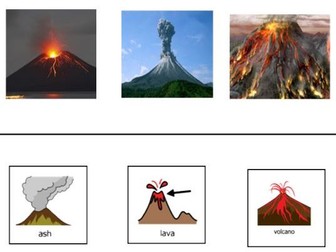
This notebook looks at volcanoes and their features. This includes links to YouTube clips and a Volcano song.
There are resources for making a quick and easy volcano with playdough and its lava. This is a one-page visual sequence / recipe.
There are also some integrated literacy skills to match aspects of vocano and sequencing stages of an erupting volcano as well as a writing sheet.
It was created for students with special needs (SEN) for teaching life skills but can be used as a valuable resource for early years literacy.
There is an accompanying visual symbol board to print.
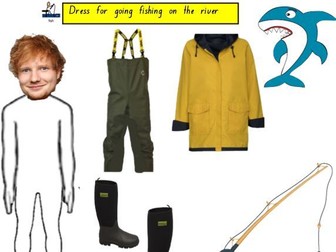
Rivers - Geographical Landforms: Parramatta River - This resource has a notebook and a worksheet.
This notebook looks at rivers and their features. It focuses on Parramatta River in Sydney, but you can easily change that feature to your local river.
It assists students in using maps.
It has a fun activity of dressing Ed Sheeran for fishing in the river. I also used that page and placed my students’ heads on the body, so that it was personalised so they could be dressed on the interactive whiteboard and on paper to fish in the river.
There are also some integrated literacy skills to match aspects of the river as well as a writing sheet.
It was created for students with special needs (SEN) for teaching life skills but can be used as a valuable resource for early years literacy.
There is an accompanying visual symbol board to print.
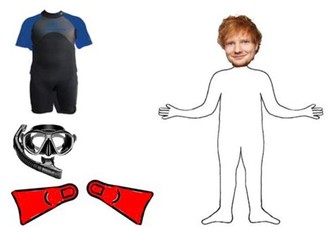
Oceans - Geographical Landforms: Bondi Beach: This resource has a notebook and a worksheet.
This notebook looks at oceans and their features. It focuses on Bondi Beach, but you can easily change that feature to your local ocean.
It assists students in using maps.
It has a fun activity of dressing Ed Sheeran for diving in the ocean. I also used that page and placed my students’ heads on the body, so that it was personalised so they could be dressed on the Interactive Whiteboard and on paper to dive in the ocean.
There are also some integrated literacy skills to match the ocean features as well as a writing sheet.
It was created for students with special needs (SEN) for teaching life skills but can be used as a valuable resource for early years literacy.
There is an accompanying visual symbol board to print.
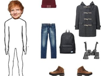
Mountains - Geographical Landforms: Blue Mountains - This resource has a notebook and a worksheet.
This notebook looks at mountains and their features. It focuses on Blue Mountains in Sydney, but you can easily change that feature to your local mountains.
It assists students in using maps.
It has a fun activity of dressing Ed Sheeran for walking in the mountains. I also used that page and placed my students’ heads on the body, so that it was personalised so they could be dressed on the interactive whiteboard and on paper to walk in the mountains.
There are also some integrated literacy skills to match aspects of the mountain as well as a writing sheet.
It was created for students with special needs (SEN) for teaching life skills but can be used as a valuable resource for early years literacy.
There is an accompanying visual symbol board to print.