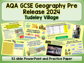
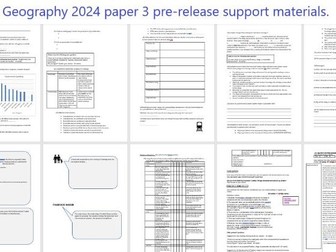
AQA GCSE Geography paper 3 pre-release support for 2024.
Tudeley Village development.
This document contains 12 pages of resources that can be set as homework to run along the pre-release booklet or taught in class.
Includes:
Exemplar answer to a question that could possibly be similar to the 9 mark question this summer. Last year’s prediction was correct as well as for 2022.
Task sheet to help student to examine the pre-release booklet.
Additional suggested questions to practice.
Now updated due to the change in the map provided by AQA.
10 ROUNDS, A TIE BREAKER 88 QUESTIONS AND A TEAM SHEET READ BELOW FOR ROUND TITLES!
Round 1: Name the 2023 Film (10 questions)
Round 2: Name the 2023 song + artist (5 questions)
Round 3: Name the Christmas covered celeb (10 questions)
Round 4: This Year in Pictures (12 Questions, multiple choice)
Round 5: Spot the difference (Timed task- 5 answers)
Round 6: Global Winter traditions (10 questions)
Round 7: Guess the Christmas Song from the Emoji’s (10 questions)
Round 8: Christmas Adverts (5 questions)
Round 9: Christmas General Knowledge (10 questions)
Round 10: Times Christmas Numeracy Task (Maths Skill- Volume)
Tie Breaker/Bonus Round (10 questions)
A 53 slide PowerPoint on the new AQA Pre Release content- Tudeley Village Development.
Also included is a mocked up practice exam paper created using the 2024 resource. This also includes a fieldwork section and can be completed in the new time of 1hr30m.
I cannot upload the resource as it is a live exam document.
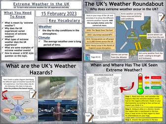
AQA GCSE Geography lesson for the new specification Unit 1A: In this lesson we look at what extreme weather is, what type of extreme weather the UK experiences and whether the UK may experience more in the future.
The lesson has a retrieval practice starter where the pupils choose the places or the circumstances where tropical storms can be found. We then look at the definition of extreme weather. The students complete a map exercise which helps to explain why the UK’s geographical location allows a variety of extreme weather to be experienced. The students then complete a spider diagram on the types of extreme weather, there are some video clips and information slides to help with this which could be a carousel activity. We then complete a map exercise where the students use an atlas to locate where the extreme weather impacted and evaluate how severe the weather event was. We finish with a GCSE-style practice question with some guidance and structure provided for the students.
Hope this saves you some valuable planning time.
https://www.tes.com/teaching-resources/shop/markthegeographer
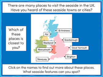
This lesson is part of The Seaside, a Geography unit designed for students in KS1 and lower KS2, but can also be taught as a stand alone lesson.
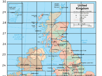
The presentation takes students on a tour of eight seaside towns and cities around the United Kingdom including: Ayr and St Andrews in Scotland; Aberystwyth in Wales; Blackpool and Newquay in England.
The activity then challenges students to use their map skills to locate these towns and cities on a map of the UK. This can be done using an atlas or the prompt maps included.
Easier - Students label 8 seaside towns and cities using a prompt map.
Medium - Students label 12 seaside towns and cities using a prompt map.
Harder - Students label 12 seaside towns and cities using an atlas.
Extension - Students locate and label 2 further seaside towns and cities from each country of the UK.
If you like this resource, we would appreciate a review! We will happily send you a free resource in return for a review or useful suggestions/feedback. Contact us at ed@teachitforward.co.uk.
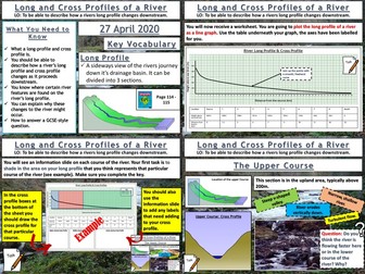
AQA GCSE Geography lesson for the new specification Unit 1C: In this lesson we look at long and cross profiles of a river and how river valleys change shape downstream.
We start with “perfect paragraph”. The pupils read a paragraph describing a drainage basin and they should try to find the errors in the paragraph and what should be added in. We then introduce long profiles, and the pupils will be plotting a long profile of a river on their worksheet. We then look at the upper, middle and lower courses of the river. The pupils shade in these sections on their graph. We complete the worksheet by looking at cross profiles and how river valley shapes change downstream. The pupils create annotated cross sections of the upper, middle and lower courses using the info slides. We finish with a 4 mark GCSE-style question “describe how the shape of a river valley changes downstream”. As always the pupils have some guidance on the question if they need it.
In a nutshell lesson includes:
Perfect paragraph starter.
Long profile plotting exercise.
Cross profile diagram activity.
4-mark GCSE-style question.
Hope this saves you some valuable planning time.
https://www.tes.com/teaching-resources/shop/markthegeographer
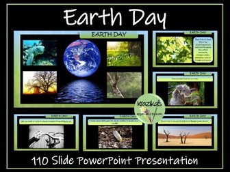
This resource contains an informative and fully editable 110-slide PowerPoint presentation on Earth Day. The presentation focuses on:
This is a fully editable and informative, 100-slide PowerPoint presentation on Earth Day. The presentation focuses on:
the history of earth day
the aims of Earth Day
environmental issues
Earth Day projects
The Earth Day 2024 theme - ‘Planet v Plastics’
How we can help to look after our wonderful planet earth
The PowerPoint also contains links to a breathtaking, 4-minute video of our planet and a link to a moving ‘Earth Song’.
Please note, the watermark on the preview images are not present on the resources themselves.
If you buy this resource and are pleased with your purchase, I would be extremely grateful if you could leave a review. As a token of appreciation, you can have a free resource of your choice up to the same value as your purchased resource. Just email inspireandeducate@aol.co.uk with your user name, the resource you have reviewed and the resource you would like for free.
A simple text version of this presentation, more appropriate for younger / SEN pupils, is also available:
Earth Day Simple Text Presentation
You may also be interested in:
Earth Day Puzzle Pack
This resource contains 10 differentiated word searches, anagram puzzles and crosswords.
Great Thunberg Presentation
Climate Change Presentation
Thinking of publishing your own resources or already an author and want to improve your resources and sales? Check out this step-by-step guide:
How to Become a Successful TES Author: Step-by-Step Guide
Investigating Rivers is a Geography unit suitable for KS2 (Y4-6).
The planning overview and topic title page can be downloaded for free here. Lessons include:
L1 - Understanding the water cycle
L2 - Identifying features of a river system
L3 - Identifying characteristics of the three stages of a river
L4 - Investigating features of the River Thames
L5 - Thinking about the different ways we use water
L6 - Understanding the impacts of floods and droughts
Each lesson includes a presentation and differentiated activities/worksheets.
If you like this resource, we would appreciate a review! We will happily send you a free resource in return for a review or useful suggestions/feedback. Contact us at ed@teachitforward.co.uk.
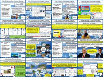
This bundle features all 6 lessons from the AQA GCSE Geography Unit 1A section on climate change. Each lesson has a variety of differentiated activities, exam questions with guidance, video clips and worksheets ready to photocopy or print.
The order of the lessons is:-
The Evidence for Climate Change
The Natural Causes of Climate Change
The Human Causes of Climate Change
The Effects of Climate Change
Managing the Impacts of Climate Change
Adapting To Climate Change
I hope this saves you valuable planning time.
https://www.tes.com/teaching-resources/shop/markthegeographer
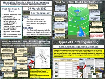
AQA GCSE Geography lesson for the new specification Unit 1C: In this lesson we look at hard engineering methods of flood management.
We start with a retrieval practice grid game based around the processes and landforms of erosion. The students then complete a cloze exercise to create a definition of what hard engineering is. We briefly introduce soft engineering, then the students have a blank diagram of a drainage basin which has undergone both hard and soft engineering strategies to reduce flooding. The students have to annotate the diagram and work out which is hard and soft engineering. The students are then given some information cards and have to record details on four methods of hard engineering:- dams and reservoirs, flood relief channels, embankments and channel straightening. The students record the advantages and disadvantages and complete a rating exercise for various factors. We finish with a 9-mark GCSE style question and there is some guidance for students who need it on how to answer it.
Hope this saves you some valuable planning time.
https://www.tes.com/teaching-resources/shop/markthegeographer
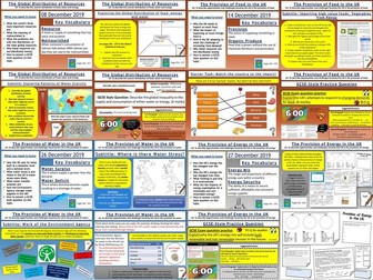
AQA GCSE Geography lessons for the Resource Management Section Unit 2C. All lessons are fully resourced, differentiated with a variety of activities and practice questions.
Lessons included are.
The Global Distribution of Resources
Provision of Food in the UK
Provision of Water in the UK
The Provision of Energy in the UK
I hope this saves you some valuable planning time.
https://www.tes.com/teaching-resources/shop/markthegeographer
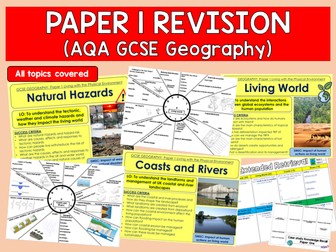
Full series of revision lessons and Resources
Session 1: Natural Hazards Revision
Revision Clock
Blockbuster
Session 2: Living World Revision
Revision Clock
Blockbuster
Session 3: Coasts and Rivers Revision
Revision Clock
Blockbuster
Featuring ALL construction resources available in my shop including the two new items: constructiion area heading cards and also the KS1 History construction area cards (both new for Summer 2023).
The bundle also includes:
design sheets, labels and work in progress siigns
construction are lettering
religious buildings construction cards
seasons construction cards
UK geography construction cards
Human, physical features and famous landmarks cards.
If all of these were to be purchased individually it would cost £14- bundle price of £10 saving nearly 30%!
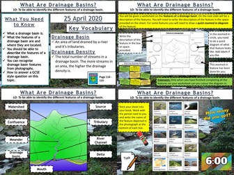
AQA GCSE Geography lesson for the new specification Unit 1C: In this lesson we look at drainage basins and what types of features you find within them.
We start with a photo mystery starter, the pupils only see fragments of a map of the drainage basins of the UK and Ireland. The pupils try to guess what the complete picture might be. This leads onto a discussion about drainage basins and the Amazon Basin in particular. Next we look at the features within a drainage basin. The pupils will work from a worksheet and are given a description of a feature. They must find the feature on the diagram, write the description, and then for some features they draw their own zoomed-in picture of the feature. Following this the pupils get a grid of photographs of the various features and they need to work out what the feature is. The board is editable so they can play bingo as well if you want to create bingo cards.
We finish with a simple post-it plenary based on a GCSE-style question.
In a nutshell lesson includes:
Geographical gallery of contemporary art starter
Worksheet activities on the features of a drainage basin
Photo grid of the features of a drainage basin.
Post-it plenary.
Hope this saves you some valuable planning time.
https://www.tes.com/teaching-resources/shop/markthegeographer
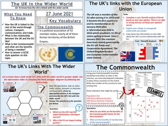
AQA GCSE Geography lesson for the new specification Unit 2B: In this lesson we look at the place of the UK in the wider world.
The lesson starts with a quick retrieval practice quiz true or false quiz. We then introduce some of the organisations that the UK is a member of and how this can give the UK global influence. The pupils then use a hexagon template to create an annotated diagram on our trade, transport, cultural and communication links. We then consider the UK’s relationship with the EU post-brexit and remind ourselves of how the UK left the EU. The pupils complete a cost/benefit analysis of this with explanation. We then look at the Commonwealth and the pupils complete an exercise that looks at the diversity of countries size and economies using indicators (Atlas or internet access needed). We then finish with a GCSE-style practice question with some guidance.
Hope this saves you some valuable planning time.
https://www.tes.com/teaching-resources/shop/markthegeographer
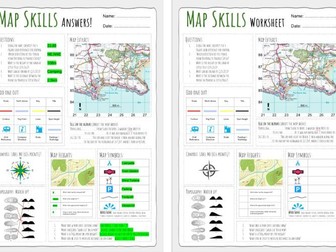
Up to date worksheet for map skills for any Geography curriculum and Key Stage.
Includes:
4fig grid references
6fig grid references
direction
compass
scale
map symbols
and more
AQA GCSE Geography
Tudeley village developement - Pre-release full mock exam 2024.
Laid out as real exams are.
Full mock paper with a range of questions.
40 marks total, designed to be completed in 1 hour.
Updated to reflect the most recent changes AQA have made to the pre-release material
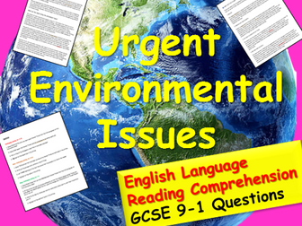
An easy to use reading comprehension pack with three sections of differentiated questions. This activity focuses on urgent environmental issues . It can be used in form time as part of literacy focus, or in an English lesson for KS3/4 GCSE comprehension training.
It is interesting, useful, very easy to use and good to raise awareness of envirornmental issues.
For everything English GCSE and KS3, free and inexpensive, check out my Tes Award nominated shop:
Lead Practioner's English Store
 Quick View