AQA GCSE Geography pre-release 2024 Tudeley Village support materialsQuick View
pnmasonukpnmasonuk

AQA GCSE Geography pre-release 2024 Tudeley Village support materials

(0)
AQA GCSE Geography paper 3 pre-release support for 2024. 
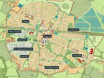
Tudeley Village development. This document contains 12 pages of resources that can be set as homework to run along the pre-release booklet or taught in class. Includes: Exemplar answer to a question that could possibly be similar to the 9 mark question this summer. Last year’s prediction was correct as well as for 2022. Task sheet to help student to examine the pre-release booklet. Additional suggested questions to practice. Now updated due to the change in the map provided by AQA.
Investigating Rivers - KS2Quick View
TeachItForwardTeachItForward

Investigating Rivers - KS2

7 Resources
Investigating Rivers is a Geography unit suitable for KS2 (Y4-6). The planning overview and topic title page can be downloaded for free here. Lessons include: L1 - Understanding the water cycle L2 - Identifying features of a river system L3 - Identifying characteristics of the three stages of a river L4 - Investigating features of the River Thames L5 - Thinking about the different ways we use water L6 - Understanding the impacts of floods and droughts Each lesson includes a presentation and differentiated activities/worksheets. If you like this resource, we would appreciate a review! We will happily send you a free resource in return for a review or useful suggestions/feedback. Contact us at ed@teachitforward.co.uk.
Map Skills Worksheet 1Quick View
josh_liversidgejosh_liversidge

Map Skills Worksheet 1

(0)
Up to date worksheet for map skills for any Geography curriculum and Key Stage. Includes: 4fig grid references 6fig grid references direction compass scale map symbols and more
Locating seaside towns and cities in the UK - KS1/KS2Quick View
TeachItForwardTeachItForward

Locating seaside towns and cities in the UK - KS1/KS2

(1)
This lesson is part of The Seaside, a Geography unit designed for students in KS1 and lower KS2, but can also be taught as a stand alone lesson. The presentation takes students on a tour of eight seaside towns and cities around the United Kingdom including: Ayr and St Andrews in Scotland; Aberystwyth in Wales; Blackpool and Newquay in England. The activity then challenges students to use their map skills to locate these towns and cities on a map of the UK. This can be done using an atlas or the prompt maps included. Easier - Students label 8 seaside towns and cities using a prompt map. Medium - Students label 12 seaside towns and cities using a prompt map. Harder - Students label 12 seaside towns and cities using an atlas. Extension - Students locate and label 2 further seaside towns and cities from each country of the UK. If you like this resource, we would appreciate a review! We will happily send you a free resource in return for a review or useful suggestions/feedback. Contact us at ed@teachitforward.co.uk.
Paper 1 AQA GCSE Geography Revision BundleQuick View
teachgeogblogteachgeogblog

Paper 1 AQA GCSE Geography Revision Bundle

(0)
Full series of revision lessons and Resources Session 1: Natural Hazards Revision Revision Clock Blockbuster Session 2: Living World Revision Revision Clock Blockbuster Session 3: Coasts and Rivers Revision Revision Clock Blockbuster
Geography Christmas QuizQuick View
mrshopehistorymrshopehistory

Geography Christmas Quiz

(1)
Celebrate Christmas this winter with your secondary Geography students with this 54 question xmas quiz for 2023 themed around the event complete with answers in both quick and question by question format. This resource is 54 question Xmas quiz spread across 5 different rounds. It is created on Microsoft Powerpoint and suitable for KS3 and KS4 secondary students. Whats included? Within this resource there are 54 questions spanning 5 rounds. A mixture of multiple choice, general knowledge and picture quiz questions. Topics range from Christmas traditions from around the world, flag picture round, capital city and country matchups, Christmas themed Geographical knowledge in addition to skyline picture round.Your learners will have so much fun engaging with this quiz. Delivery and timings The answers can then shared as a class by going through each question individually (ensure you are in present mode for the correct answer to colour yellow and the transitions to work) for students to peer or self mark. Additionally, answers to each individual question can be found on the notes section of each individual PowerPoint slide. If you choose to deliver this in a single session - it could take upto (but not in excess of) an hour to complete depending on how much thinking time you decide to give your students. However, the rounds have been sectioned off within the Powerpoint so that you could potentially delivered a round or two at a time with your classes or tutor groups over the period of a week or two. I really hope you enjoy this quiz activity. If you get the time, please leave a review - for a limited time I am offering a FREE copy of my Christmas Dingbats resource for every review left. So please leave your email address in the review so I can be sure to get this across to you! Looking for more Christmas resources? Check out this Christmas anagram worksheet activity Christmas 2023 Tutor time Quiz Christmas Dingbats resource FREE Seek and Find Christmas resource #geography #christmas #christmasquiz #xmas #xmasquiz #geographyquiz
Identifying the world's climate zones - KS1/KS2Quick View
TeachItForwardTeachItForward

Identifying the world's climate zones - KS1/KS2

(3)
This lesson is an ideal introduction to the world’s three main climate zones. It is part of Our World, a Geography unit designed for students in KS1 and lower KS2 (Y1-3), but can also be taught as a stand alone lesson. First the presentation helps students understand that different places in the world have different climates. It then looks at the location of the Equator and North/South poles, and how these relate to the three main climate zones. To keep things simple, these are referred to as hot (tropical), mild (temperate) and cold (frigid). The activity challenges students to locate the Equator and poles and then identify various climate zones around the world. It is differentiated two ways: Easier – Students identify the climate zone of 8 numbered points around the world. Harder – Students identify climate zone and continent of 8 numbered points around the world. Extension – Students cut and stick pictures of four animals – elephant, lion, polar bear and penguin – onto their world climate zone map. If you like this resource, we would appreciate a review! We will happily send you a free resource in return for a review or useful suggestions/feedback. Contact us at ed@teachitforward.co.uk.
Identifying the key features of mountains - KS2Quick View
TeachItForwardTeachItForward

Identifying the key features of mountains - KS2

(3)
This is the first lesson in Mountain Environments, a Geography unit designed for students in upper KS2 (Y4-6). First the presentation introduces students to the topic and looks at some of the activities people do in mountains. It then introduces the key features of a mountain range. The activity challenges students to identify the key features of a mountain environment. It is differentiated three ways: Easier – Students identify 8 key features of mountains. Medium – Students identify 10 key features of mountains. Harder – Students label the key features of mountains in their exercise book. Extension – Students match mountain vocabulary to their definitions. If you like this resource, we would appreciate a review! We will happily send you a free resource in return for a review or useful suggestions/feedback. Contact us at ed@teachitforward.co.uk.
Geography Christmas QuizQuick View
Cre8tive_ResourcesCre8tive_Resources

Geography Christmas Quiz

(3)
Geography Christmas Quiz – Christmas 50+ Questions for that perfect end of term subject based lesson. This Christmas quiz has a mixture of questions and rounds and skills. Some of the rounds will be subject based with subject based knowledge whilst others will be Christmas themed giving that perfect mix for an end of term Christmas lesson. This resource will last a full 50 minutes to 1 hour. This Geography resource contains: 1x PowerPoint with questions and answers 1x Student Answer Sheet double sided out of /54+ Marks 3 sets of Editable Team Certificates (1st place, 2nd place and 3rd place) Skills reflection slide Personal reflection questions What does the Geography Christmas quiz comprise of? Round 1: Identify winter inspired images Round 2: True or False - good variety of themed questions **Round 3: ** Matching and strategy can you find the correct links and eliminate all others Round 4: Linking Round - be able to make the correct links between left and right lists Round 5: Numbers Round -all the answers will involve numbers. Round 6: Jumbled up Round - Unravel these to find the answer staring directly back at you Round 7: Multiple Choice theory - Put your team to the test Round 8: Observation Round - Look at the image , remember everything you see…. Round 9: Wordsearch Round - Locate the words before time runs out… **Round 10: ** Tie Breaker - Design it but use all your team’s creative abilities This will last a full hour for the full quiz by the time you get students into small teams and run through the quiz and the interactive way the answers appear. This informative, fun and engaging quiz will be a great way to celebrate the end of term and Christmas. Search ‘Cre8tive Resources’ for support with our library of resources or send us an email. Leave a review and email TheCre8tiveResources@gmail.com for a free resource as a thank you!! Explore all our resources on TES
AQA GCSE Geography pre-release full mock exam 2024Quick View
Dhillon31Dhillon31

AQA GCSE Geography pre-release full mock exam 2024

(0)
AQA GCSE Geography Tudeley village developement - Pre-release full mock exam 2024. Laid out as real exams are. Full mock paper with a range of questions. 40 marks total, designed to be completed in 1 hour. Updated to reflect the most recent changes AQA have made to the pre-release material
Introduction to latitude and longitude - KS2/KS3Quick View
TeachItForwardTeachItForward

Introduction to latitude and longitude - KS2/KS3

(3)
This lesson is part of Understanding Latitude and Longitude, a unit designed for students in upper KS2 and KS3. It can also be taught as a stand-alone lesson. The presentation introduces the concept of lines of latitude and longitude, including the Equator and Prime Meridian, and goes on to explain their purpose and relationship to Earth’s hemispheres and poles. In the activity, students have to identify all of these features on diagrams of the Earth. It is differentiated two ways and includes an extension: Easier – Students have label clues and a vocabulary bank to help them. Harder – Students have only a vocabulary bank to help them. Extension – Students fill in the missing words in a text about latitude and longitude. If you like this resource, we would appreciate a review! We will happily send you a free resource in return for a review or useful suggestions/feedback. Contact us at ed@teachitforward.co.uk.
Mountain Environments - KS2Quick View
TeachItForwardTeachItForward

Mountain Environments - KS2

8 Resources
Mountain Environments is a Geography unit suitable for KS2 (Y4-6) and has everything you need for covering a mountains topic. The planning overview, topic title page and vocabulary page can be downloaded for free here. Lessons include: L1 – Identifying the key features of mountains L2 – Identifying the world’s major mountain ranges L3 – Locating the world’s famous mountains using latitude and longitude L4 – Understanding how fold mountains are formed L5 – Investigating the structure of a volcano (FREE) L6 – Researching famous world mountains (FREE) L7 – Investigating mountain climates Each lesson includes a presentation and differentiated activities/worksheets. If you like this resource, we would appreciate a review! We will happily send you a free resource in return for a review or useful suggestions/feedback. Contact us at ed@teachitforward.co.uk.
UK Grid Reference MapQuick View
alisha2107alisha2107

UK Grid Reference Map

(1)
Differentiated maps of the UK with grid references - children are to identify locations in each grid reference
Earthquakes - KS2Quick View
TeachItForwardTeachItForward

Earthquakes - KS2

8 Resources
Earthquakes is an exciting Geography unit designed for students in KS2. The planning overview, topic title page and vocabulary page can be downloaded for free here. Lessons include: L1 – Understanding the structure of the Earth L2 – Understanding tectonic plates L3 – Understanding the causes of earthquakes L4 – Investigating the five deadly features of an earthquake L5 – Researching earthquakes using Wikipedia L6 – Locating the world’s biggest earthquakes using latitude & longitude L7 – Writing a fact file about a famous earthquake Each lesson includes a presentation and differentiated activities/worksheets. If you like this resource, we would appreciate a review! We will happily send you a free resource in return for a review or useful suggestions/feedback. Contact us at ed@teachitforward.co.uk.
Volcanoes & Earthquakes - KS2Quick View
TeachItForwardTeachItForward

Volcanoes & Earthquakes - KS2

14 Resources
Volcanoes & Earthquakes is an exciting extended Geography unit designed for students in KS2. The planning overview, topic title page and vocabulary page can be downloaded for free here. Lessons include: L1 – Understanding the structure of the Earth L2 – Investigating the structure of a volcano (FREE) L3 – Locating the world’s famous volcanoes L4 – Investigating the five deadly features of a volcanic eruption L5 – Understanding tectonic plates L6 – Exploring the effects of volcanic eruptions on Montserrat L7 – Why do people live near volcanoes? L8 – Understanding the causes of earthquakes L9 – Investigating the five deadly features of an earthquake L10 – Researching earthquakes using Wikipedia L11 – Locating the world’s biggest earthquakes using latitude & longitude L12 – Writing a fact file about a famous earthquake Each lesson includes a presentation and differentiated activities/worksheets. A FREE newspaper report template is also included in this unit. If you like this resource, we would appreciate a review! We will happily send you a free resource in return for a review or useful suggestions/feedback. Contact us at ed@teachitforward.co.uk.
Chi Square Test Edexcel A level from 2016Quick View
TheFenlandFieldTutorTheFenlandFieldTutor

Chi Square Test Edexcel A level from 2016

(3)
I cannot claim any real credit as the information came from: http://www.tutor2u.net/geography/reference/chi-squared-test I have merely made a powerpoint around this. Aimed at A level Edexcel Geography from 2016 with an eye on their coasts fieldwork. I hope you find this useful.
Map Skills ResourcesQuick View
Victoria1987Victoria1987

Map Skills Resources

(46)
Resources for teaching map skills to year 7 covering a range of skills Activities have been collated from a variety of free resources over the years - I'm sharing this SoW to help others with planning and resourcing. If there is work of yours I will happily credit it in the resource description, just let me know. Topics covered Longitude and latitude 4 and 6 figure grid references (some resources adapted from https://www.tes.com/teaching-resource/4-and-6-figure-grid-references-6373196) Map symbols Scale (some resources adapted https://www.tes.com/teaching-resource/what-is-scale-6169040 and https://www.tes.com/teaching-resource/scale-drawing-and-maps-6280918) Height
Locating volcanoes using latitude and longitudeQuick View
idjidj

Locating volcanoes using latitude and longitude

(12)
This activity looks at the location of famous volcanoes with the pupils having to locate them on a map using their lines of latitude and longitude. It is a colourful, child-friendly design. We did it in A4 which worked well although I can see how A3 would work well too.