Investigating Rivers is a Geography unit suitable for KS2 (Y4-6).
The planning overview and topic title page can be downloaded for free here. Lessons include:
L1 - Understanding the water cycle
L2 - Identifying features of a river system
L3 - Identifying characteristics of the three stages of a river
L4 - Investigating features of the River Thames
L5 - Thinking about the different ways we use water
L6 - Understanding the impacts of floods and droughts
Each lesson includes a presentation and differentiated activities/worksheets.
If you like this resource, we would appreciate a review! We will happily send you a free resource in return for a review or useful suggestions/feedback. Contact us at ed@teachitforward.co.uk.
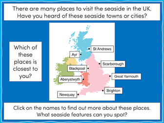
This lesson is part of The Seaside, a Geography unit designed for students in KS1 and lower KS2, but can also be taught as a stand alone lesson.
The presentation takes students on a tour of eight seaside towns and cities around the United Kingdom including: Ayr and St Andrews in Scotland; Aberystwyth in Wales; Blackpool and Newquay in England.
The activity then challenges students to use their map skills to locate these towns and cities on a map of the UK. This can be done using an atlas or the prompt maps included.
Easier - Students label 8 seaside towns and cities using a prompt map.
Medium - Students label 12 seaside towns and cities using a prompt map.
Harder - Students label 12 seaside towns and cities using an atlas.
Extension - Students locate and label 2 further seaside towns and cities from each country of the UK.
If you like this resource, we would appreciate a review! We will happily send you a free resource in return for a review or useful suggestions/feedback. Contact us at ed@teachitforward.co.uk.
Featuring ALL construction resources available in my shop including the two new items: constructiion area heading cards and also the KS1 History construction area cards (both new for Summer 2023).
The bundle also includes:
design sheets, labels and work in progress siigns
construction are lettering
religious buildings construction cards
seasons construction cards
UK geography construction cards
Human, physical features and famous landmarks cards.
If all of these were to be purchased individually it would cost £14- bundle price of £10 saving nearly 30%!
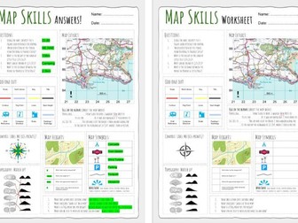
Up to date worksheet for map skills for any Geography curriculum and Key Stage.
Includes:
4fig grid references
6fig grid references
direction
compass
scale
map symbols
and more
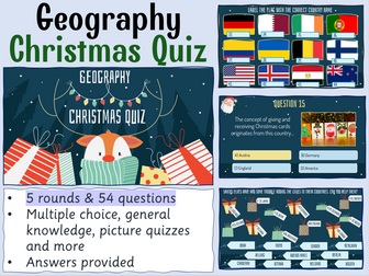
Celebrate Christmas this winter with your secondary Geography students with this 54 question xmas quiz for 2023 themed around the event complete with answers in both quick and question by question format. This resource is 54 question Xmas quiz spread across 5 different rounds. It is created on Microsoft Powerpoint and suitable for KS3 and KS4 secondary students.
Whats included?
Within this resource there are 54 questions spanning 5 rounds. A mixture of multiple choice, general knowledge and picture quiz questions. Topics range from Christmas traditions from around the world, flag picture round, capital city and country matchups, Christmas themed Geographical knowledge in addition to skyline picture round.Your learners will have so much fun engaging with this quiz.
Delivery and timings
The answers can then shared as a class by going through each question individually (ensure you are in present mode for the correct answer to colour yellow and the transitions to work) for students to peer or self mark. Additionally, answers to each individual question can be found on the notes section of each individual PowerPoint slide.
If you choose to deliver this in a single session - it could take upto (but not in excess of) an hour to complete depending on how much thinking time you decide to give your students. However, the rounds have been sectioned off within the Powerpoint so that you could potentially delivered a round or two at a time with your classes or tutor groups over the period of a week or two.
I really hope you enjoy this quiz activity. If you get the time, please leave a review - for a limited time I am offering a FREE copy of my Christmas Dingbats resource for every review left. So please leave your email address in the review so I can be sure to get this across to you!
Looking for more Christmas resources?
Check out this Christmas anagram worksheet activity
Christmas 2023 Tutor time Quiz
Christmas Dingbats resource
FREE Seek and Find Christmas resource
#geography #christmas #christmasquiz #xmas #xmasquiz #geographyquiz
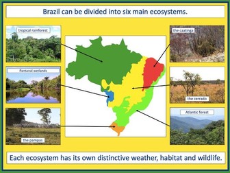
This lesson is part of Exploring Brazil, a Geography unit designed for students in KS2 (Y4-6), but can also be taught as a stand alone lesson.
The presentation introduces students to Brazil’s six main biomes including the tropical rainforest, caatinga (desert), Pantanal wetlands, cerrado (savannah) and Atlantic Forest. Students then read an information text to find out more.
In the activity, students write an information text about Brazil’s ecosystems. This can either be done as a short activity or as an extended write in Literacy. (N.B. The activity sheets need to be enlarged to A3 size to provide adequate space for writing.)
Short Activity:
Easier – Students match statements to each ecosystem and write them in each box.
Medium – Students add titles, then match statements to each ecosystem and write them in each box.
Harder – Students add titles and write their own sentences about each ecosystem in the box.
Extension – Students label the different ecosystems on the map, including drawings of animals found in each one.
Extended Writing Activity:
Easier – Students write an information text about Brazil’s ecosystems, including an introductory paragraph.
Harder – Students write an information text about Brazil’s ecosystems, including sub-headings and an introductory paragraph.
If you like this resource, we would appreciate a review! We will happily send you a free resource in return for a review or useful suggestions/feedback. Contact us at ed@teachitforward.co.uk.
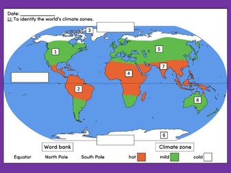
This lesson is an ideal introduction to the world’s three main climate zones.
It is part of Our World, a Geography unit designed for students in KS1 and lower KS2 (Y1-3), but can also be taught as a stand alone lesson.
First the presentation helps students understand that different places in the world have different climates. It then looks at the location of the Equator and North/South poles, and how these relate to the three main climate zones. To keep things simple, these are referred to as hot (tropical), mild (temperate) and cold (frigid).
The activity challenges students to locate the Equator and poles and then identify various climate zones around the world. It is differentiated two ways:
Easier – Students identify the climate zone of 8 numbered points around the world.
Harder – Students identify climate zone and continent of 8 numbered points around the world.
Extension – Students cut and stick pictures of four animals – elephant, lion, polar bear and penguin – onto their world climate zone map.
If you like this resource, we would appreciate a review! We will happily send you a free resource in return for a review or useful suggestions/feedback. Contact us at ed@teachitforward.co.uk.
1 hour lesson. 6 rounds of quiz questions. Answers included, after each round.
All you need to quiz teams, a piece of paper and pen.
Round 1 - Name the Easter Egg
Round 2 - General knowledge. Easter Traditions.
Round 3 - Flags
Round 4 - Word Scramble
Round 5 - Famous bunnies
Round 6 - Easter Celebrities
Well worth it for £1!
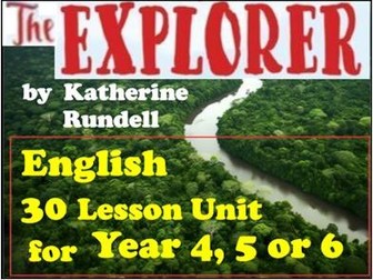
30 lessons – ‘The Explorer’ by Katherine Rundell – Year 4/5/6 – English planning
A whole term’s English planning linked to the book ‘The Explorer’ (Winner of the Children’s Book Prize Winner of the Costa Children’s Book Award 2017) by Katherine Rundell. This story fits well with any topic linked work about South America, as it is set in the Amazon Rainforest.
Ideal for Year 4, Year 5 or Year 6 children.
There are 30 lessons in total, all with SMART Notebook screens, task sheets and header sheets.
To assist teaching, there are a total of 149 SMART Notebook screens and each lesson is clearly marked along with which lesson each chapter should be read to aid and link to the learning.
(Update - I personally use SMART Notebook files in my own lessons. In response to many requests, I have converted the SMART Notebook screens to Powerpoint, so there is also a Powerpoint presentation included for the teaching sequence for those unable to use SMART Notebook. However, please note that while the SMART Notebook screens can be edited, the Powerpoint screens can not be edited as they are screen snips from the SMART Notebook file.)
This planning includes:
Writing a narrative
Writing a persuasive letter
SATs style comprehension questions
Journal writing
Writing an information text
Recording a radio broadcast
This book and planning link well with topic work on South America, Brazil, the Amazon Rainforest and the Yanomami indigenious tribe. It will also educate and inform the children of a very current real problem that others in the world face - the destruction of the rainforest.
Some comments from reviews on this resource:
‘This resource is absolutely brilliant - it has everything you need for a term’s worth of work on The Explorer … in an engaging and fun way. Perfect!’ (staylor138)
‘Fantastic and well worth the money, a very broad range of activities that are very well planned and resourced.’ (taylor29)
‘Great resource- such a timesaver!’ (penrich1)
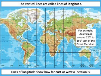
This lesson is part of Understanding Latitude and Longitude, a unit designed for students in upper KS2 and KS3. It can also be taught as a stand-alone lesson.
The presentation introduces the concept of lines of latitude and longitude, including the Equator and Prime Meridian, and goes on to explain their purpose and relationship to Earth’s hemispheres and poles.
In the activity, students have to identify all of these features on diagrams of the Earth. It is differentiated two ways and includes an extension:
Easier – Students have label clues and a vocabulary bank to help them.
Harder – Students have only a vocabulary bank to help them.
Extension – Students fill in the missing words in a text about latitude and longitude.
If you like this resource, we would appreciate a review! We will happily send you a free resource in return for a review or useful suggestions/feedback. Contact us at ed@teachitforward.co.uk.
Mountain Environments is a Geography unit suitable for KS2 (Y4-6) and has everything you need for covering a mountains topic.
The planning overview, topic title page and vocabulary page can be downloaded for free here. Lessons include:
L1 – Identifying the key features of mountains
L2 – Identifying the world’s major mountain ranges
L3 – Locating the world’s famous mountains using latitude and longitude
L4 – Understanding how fold mountains are formed
L5 – Investigating the structure of a volcano (FREE)
L6 – Researching famous world mountains (FREE)
L7 – Investigating mountain climates
Each lesson includes a presentation and differentiated activities/worksheets.
If you like this resource, we would appreciate a review! We will happily send you a free resource in return for a review or useful suggestions/feedback. Contact us at ed@teachitforward.co.uk.
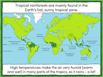
This lesson is part of Tropical Rainforests, a Geography unit designed for students in KS2, but can also be taught as a stand alone lesson. All resources are compatible with both Microsoft Office and Google Workspace.
The presentation introduces students to tropical rainforests, including some of the flora and fauna that live in them. Students then learn about the Earth’s tropical belt and the location of the various rainforests within it.
The activity challenges students to label features of a world map including the Equator, the Tropic of Cancer and the Tropic of Capricorn. Students then locate 8 of the world’s tropical rainforests.
Easier - Students use a prompt map and have activity clues.
Harder - Students use a prompt map but have no activity clues.
Extension - Students fill in the missing words in a paragraph about tropical rainforests.
If you like this resource, we would appreciate a review! We will happily send you a free resource in return for a review or useful suggestions/feedback. Contact us at ed@teachitforward.co.uk.
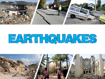
Earthquakes is an exciting Geography unit designed for students in KS2.
The planning overview, topic title page and vocabulary page can be downloaded for free here. Lessons include:
L1 – Understanding the structure of the Earth
L2 – Understanding tectonic plates
L3 – Understanding the causes of earthquakes
L4 – Investigating the five deadly features of an earthquake
L5 – Researching earthquakes using Wikipedia
L6 – Locating the world’s biggest earthquakes using latitude & longitude
L7 – Writing a fact file about a famous earthquake
Each lesson includes a presentation and differentiated activities/worksheets.
If you like this resource, we would appreciate a review! We will happily send you a free resource in return for a review or useful suggestions/feedback. Contact us at ed@teachitforward.co.uk.
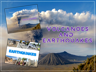
Volcanoes & Earthquakes is an exciting extended Geography unit designed for students in KS2.
The planning overview, topic title page and vocabulary page can be downloaded for free here. Lessons include:
L1 – Understanding the structure of the Earth
L2 – Investigating the structure of a volcano (FREE)
L3 – Locating the world’s famous volcanoes
L4 – Investigating the five deadly features of a volcanic eruption
L5 – Understanding tectonic plates
L6 – Exploring the effects of volcanic eruptions on Montserrat
L7 – Why do people live near volcanoes?
L8 – Understanding the causes of earthquakes
L9 – Investigating the five deadly features of an earthquake
L10 – Researching earthquakes using Wikipedia
L11 – Locating the world’s biggest earthquakes using latitude & longitude
L12 – Writing a fact file about a famous earthquake
Each lesson includes a presentation and differentiated activities/worksheets.
A FREE newspaper report template is also included in this unit.
If you like this resource, we would appreciate a review! We will happily send you a free resource in return for a review or useful suggestions/feedback. Contact us at ed@teachitforward.co.uk.
Understanding Trade is a Geography unit suitable for upper KS2 (Y5-6) and is a great way to teach students about global trade.
The planning overview, topic title page and vocabulary page can be downloaded for free here. Lessons include:
L1 – Investigating where the products we buy come from
L2 – Understanding that all products have a supply chain
L3 – Exploring the chocolate supply chain
L4 – Investigating the UK’s biggest exports
L5 – Investigating the highest value exports of different countries
L6 – Is the banana trade fair? (FREE)
Each lesson includes a presentation and differentiated activities/worksheets.
If you like this resource, we would appreciate a review! We will happily send you a free resource in return for a review or useful suggestions/feedback. Contact us at ed@teachitforward.co.uk.
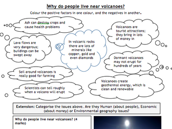
This lesson is designed for KS2 students. It can be taught as a stand alone lesson but is also available as part of two wider units, both of which are available on TES:
-Volcanoes
-Volcanoes & Earthquakes
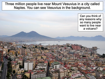
First the presentation looks at Mount Etna and Mount Vesuvius in Italy and asks why people choose to live so close to volcanoes.
The activities then challenges students to think about the advantages and disadvantages of living near a volcano:
Partner Activity:
Students sort statements and photos into advantages and disadvantages of living near a volcano.
Writing Activity:
Students write about the advantages and disadvantages of living near a volcano. Stickers and a vocabulary prompt are provided for this activity.
If you like this resource, we would appreciate a review! We will happily send you a free resource in return for a review or useful suggestions/feedback. Contact us at ed@teachitforward.co.uk.
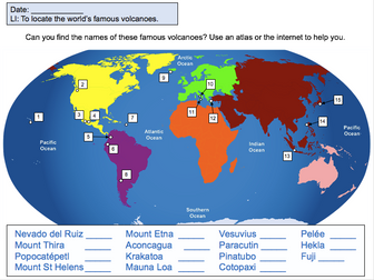
This lesson is designed for KS2 students. It can be taught as a stand alone lesson but is also available as part of two wider units, both of which are available on TES:
-Volcanoes
-Volcanoes & Earthquakes
First the presentation introduces some of the world’s most famous volcanoes and classes them as active, dormant or extinct.
The activity then challenges students to locate volcanoes using an atlas or the internet (e.g. Google maps). Alternatively, a map of famous world volcanoes is also provided.
Easier – Students locate volcanoes using the map of famous volcanoes (writing numbers).
Medium – Students locate volcanoes using the map of famous volcanoes (writing volcano names).
Harder – Students locate volcanoes using an atlas.
(N.B. It is recommended you check the atlas has the relevant maps prior doing the activity.)
If you like this resource, we would appreciate a review! We will happily send you a free resource in return for a review or useful suggestions/feedback. Contact us at ed@teachitforward.co.uk.
Worksheet with simple categorising task, plus GCSE-style 4-mark question with writing frame / help and example (tourists visiting hot springs in Iceland).
Also see:
My TES shop for all other resources.
I made this presentation for my year 2 group. It can be adapted for KS2 as well. The information used is from the website http://www.theschoolrun.com/homework-help/india. All I did was re-arranging the information differently and adding more pictures.
You can cutomise it by adding cool animation and maybe some music, I'm not so good with these things.
Hope you find it useful.
 Quick View