Hero image

Lovelearninggeography's Shop

Average Rating4.82
(based on 57 reviews)

Hi, A few years ago someone asked, ‘Is your work life stressful’? I was extremely stressed! Never enough time for myself/family. I was completely overloaded, overwhelmed & had no work life balance. I realised the most important thing I needed was time. So, after 20 years I am taking some time out. My intention is to create high quality resources, to help teachers take control of their workload, help reduce stress & enable their children to Love Learning Geography.

119Uploads

171k+Views

96k+Downloads

Hi, A few years ago someone asked, ‘Is your work life stressful’? I was extremely stressed! Never enough time for myself/family. I was completely overloaded, overwhelmed & had no work life balance. I realised the most important thing I needed was time. So, after 20 years I am taking some time out. My intention is to create high quality resources, to help teachers take control of their workload, help reduce stress & enable their children to Love Learning Geography.
4 Figure Grid References
LovelearninggeographyLovelearninggeography

4 Figure Grid References

(8)
Geography Map Skills A Free example of my work. I hope you love it. This Lesson Is About Four Figure Grid References and is suitable for ks2 and foundation ks3 students. This lesson is quite difficult to teach so I have created a resource that is easy to follow. The power point information is easy to follow and is suitable for a non-specialist teachers/parents. The resources are vibrant, interesting and have fun activities. Students must be able to use 4 figure grid references before they use OS maps & 6-figure grid references. What will your students learn: • What are grid references? • What does figure mean? • How to read 4-Figure Grid References • The three rules of using grid references Includes: • An Interactive PowerPoint presentation • Student 4x Work Sheets • Sources: Pixabay • ©Love Learning Geography Tips * NEVER use along the corridor and up the stairs. It is confusing! They will end up with a backwards ‘L’. Students always get it wrong if they use this method. They end up in the wrong grid* You can laminate the grids to use over again and save money. Remind students to use their ‘L’. Sometimes, students actually draw a small ‘L’ on their hand. Encourage students to use their index fingers to find the corner of the ‘L’. The resources will help support student’s learning, development, and attainment. Student’s will gain more confidence and develop their geographical knowledge and skills. The power point can be used on a white board or with a projector. It has animations and moving objects. To help SEN students, I have included a variety of learning styles. All font is in Comic sans, to support dyslexic learners. The power points can be easily adapted to meet the needs of higher-level learners. 6 FIGURE now available in my TES shop Thank you for looking at my resources. If you download or purchase any of my resources, I would really appreciate feedback. I would love to hear from you! This resource has taken 10 hours to create. If your love my resource, it has saved you time and reduced your workload… I would really appreciate a 5 star review. If you like my style have a look at my previews on my Facebook & Instagram page- link in bio I hope your class loves learning with my resources :) T&C By purchasing my resources, you are agreeing that the contents are the property of Love Learning Geography and licensed to you only for classroom/personal use as a single user. I retain copyright and reserve all rights to this product. You are not permitted to resell or share this item. You may not share it anywhere online (except on secure platforms with your own students).
Primary Geography Subject Leaders Guide
LovelearninggeographyLovelearninggeography

Primary Geography Subject Leaders Guide

(0)
Primary Geography Subject Leaders Pack A step by step guide designed to help you develop Geography within your school. This will save you so much time. It is easy to follow and will help build confidence in geography. Suitable for a non-specialist. Includes a vibrant interactive power point, Geography audit, Geography subject knowledge quiz, checklist and worksheets. Ask your school to purchase this ready to use resource now and take control of your workload. My aim is to help you grow in confidence, save time and reduce your work load . I hope my resources inspire you and you love teaching geography :) A preview is available on fb page. Follow my Facebook & Instagram page- link in bio Information covered Where do I start? Geography Subject Knowledge Audit pdf Subject Knowledge Quiz & Answers Geography Resources Audit How is Geography taught in your school? Geography Checklist Background information about being a Geography subject leader What makes an effective leader? How do I create a scheme of work? What is your vision? How to create a cohesive department Ofsted & The geography department What did I implement? Sources:Pixabay (unless stated) © Love Learning Geography Thank you for looking at my resources. If you download or purchase any of my resources, I would really appreciate feedback. I would love to hear from you! T&C By purchasing my resources, you are agreeing that the contents are the property of Love Learning Geography and licensed to you only for classroom/personal use as a single user. I retain copyright and reserve all rights to this product. You are not permitted to resell or share this item. You may not share it anywhere online (except on secure platforms with your own students).
6 Figure Grid References Skills
LovelearninggeographyLovelearninggeography

6 Figure Grid References Skills

(0)
Map Skills- This Lesson Is About Six Figure Grid References and is suitable for KS2 and foundation KS3 students. This lesson is quite difficult to teach so I have created a resource that is easy to follow. The power point information is suitable for a non-specialist teachers/parents. The resources are vibrant, interesting and have fun activities. Students must be able to use 4 figure grid references before they use OS maps & 6-figure grid references. If your student’s are not confident with 4 figure grid references- have a look at my 4-figure resource. I hope you love this resource. It has taken me 12 hours to create it. The ppt and sheets can be adapted. Ask your school to purchase this ready to use resource now and take control of your workload. A preview is available on my Facebook & Instagram page- link in bio What will your students learn: • Recap -What are grid references? • What is an OS map? • How to read 6-Figure Grid References • Finding 6-Figure Grid References • Finding 6-Figure Grid References on an OS map Includes: • An Interactive PowerPoint presentation • Student 3x Work Sheets • Sources: Pixabay and Ordnance Survey (teacher resources) • ©Love Learning Geography Tips • NEVER use along the corridor and up the stairs. It is confusing! They will end up with a backwards ‘L’. Students always get it wrong if they use this method. They end up in the wrong grid* • Remind students to use their ‘L’. Sometimes, students actually draw a small ‘L’ on their hand. Encourage students to use their index fingers to find the corner of the ‘L’. • Remember to write the 4 figure grid references in the two circles and underline the third and sixth number The resources will help support student’s learning, development, and attainment. Student’s will gain more confidence and develop their geographical knowledge and skills. The power point can be used on a white board or with a projector. It has animations and moving objects. To help SEN students, I have included a variety of learning styles. All font is in Comic sans, to support dyslexic learners. The power points can be easily adapted to meet the needs of higher-level learners. Follow my Facebook & Instagram page- link in bio Thank you for looking at my resources. If you download or purchase any of my resources, I would really appreciate feedback. I would love to hear from you! I hope your class loves learning with my resources :) T&C By purchasing my resources, you are agreeing that the contents are the property of Love Learning Geography and licensed to you only for classroom/personal use as a single user. I retain copyright and reserve all rights to this product. You are not permitted to resell or share this item. You may not share it anywhere online (except on secure platforms with your own students).
World Climate Zones
LovelearninggeographyLovelearninggeography

World Climate Zones

(0)
World Climate Zones This lesson is about world climate zones and is suitable for ks2 and foundation ks3 students… The power point information is easy to follow and is suitable for a non-specialist teachers/parents. The resources are vibrant, interesting and have fun activities. Ask your school to purchase this ready to use ppt now and take control of your workload. What will your students learn: • Recap longitude and latitude • What is the difference between weather and climate? • What is the difference between hot, cold and mild climates? • Continents and climate zones • Plants in different climate zones • Divide the world into polar, tropical and temperate zones • What is the climate zone in the UK? • Fieldwork activity- Monitoring the weather Includes: • An Interactive PowerPoint presentation • Student Work Sheets and test questions • Sources: Pixabay (unless stated) • ©Love Learning Geography Part of the Physical KS2 geography pack. See a preview on my Facebook & Instagram page- link in bio Thank you for looking at my resources. If you download or purchase any of my resources, I would really appreciate the feedback. I would love to hear from you! *I hope your students love learning geography :) * T&C By purchasing my resources, you are agreeing that the contents are the property of Love Learning Geography and licensed to you only for classroom/personal use as a single user. I retain copyright and reserve all rights to this product. You are not permitted to resell or share this item. You may not share it anywhere online (except on secure platforms with your own students).
Geography Baseline Assessment Test
LovelearninggeographyLovelearninggeography

Geography Baseline Assessment Test

(0)
Geography Baseline Assessment A year 7 Geography baseline assessment. An effective way of ascertaining what students already know from Key Stage 2. What the assessment covers: • Section 1- World Maps • Section 2- Europe • Section 3- British Isles • Section 4- OS Skills • Section 5- Geography Knowledge- Multiple Choice • Section 6- Exam Style questions (only baseline assessment 2) Includes: • An animated PowerPoint presentation- Instructions and answers • Student Work Sheets – baseline assessment 1 & 2 • Lesson plan • Teacher results grid • Sources: Pixabay (unless stated) • ©Love Learning Geography The assessment is divided into 6 sections. There is an animated & vibrant power point. It explains how to complete the assessment step by step. It also has the ANSWERS (yay) to each questions. It can be adapted. I have included 2 baseline assessments. Baseline assessment 1 Includes Section 1-5. Baseline assessment 2 includes Sections 1-6. The baseline booklets are in pdf. To help SEN students I have included a variety of learning styles. All font is in Comic sans, to support dyslexic learners. Suitable for a non-specialist. This will save you so much time. The results will help you adapt your year 7 schemes of work. It is easy to follow and will help students understand their gaps in their knowledge. Complete the assessment again and show progression. See a preview on my Facebook & Instagram page- link in bio Thank you for looking at my resources. If you download or purchase any of my resources, I would really appreciate the feedback. I would love to hear from you! **I hope your students love learning geography :) ** T&C By purchasing my resources, you are agreeing that the contents are the property of Love Learning Geography and licensed to you only for classroom/personal use as a single user. I retain copyright and reserve all rights to this product. You are not permitted to resell or share this item. You may not share it anywhere online (except on secure platforms with your own students).
KS2 Geography UK Atlas Booklet Cover Work
LovelearninggeographyLovelearninggeography

KS2 Geography UK Atlas Booklet Cover Work

(0)
A Great Time Saving booklet or I have used for Cover lessons. What’s the difference? Great Britain, United Kingdom & British Isles ks2 ks3 vibrant easy to follow. The 8 page resource booklet will help your students learn the difference between Great Britain, the United Kingdom, and the British Isles. It can be used for KS2 and KS3 foundation pupils. It is easy to follow and has different activities. Parents’ work through the booklet step by step. There are 30 questions /activities to complete. The do not need the Internet to complete the tasks. You could print off the booklet for any disadvantaged students to review at home. It will help students build their confidence in geography. Students can work at their own pace. The booklet is in pdf. My aim is to improve the transition from primary to secondary geography. It is suitable for a non-specialist. To help SEN students I have included a variety of learning styles. All font is in Comic sans, to support dyslexic learners. What will your students learn: • What is a country? • Atlas/ Map work • Flag work • What makes up Great Britain? • What countries are in the UK? • The difference between GB, UK and the British Isles. Includes: • An 8 page student booklet • Answer sheet • Sources: Pixabay • ©Love Learning Geography If you need to recap the information about GB, UK and the BI- Have a look in my TES shop. It covers everything you need. Thank you for looking at my resources. If you download or purchase any of my resources, I would really appreciate the feedback. I would love to hear from you! *I hope your students love learning geography :) * T&C By purchasing my resources, you are agreeing that the contents are the property of Love Learning Geography and licensed to you only for classroom/personal use as a single user. I retain copyright and reserve all rights to this product. You are not permitted to resell or share this item. You may not share it anywhere online (except on secure platforms with your own students).
North & South America
LovelearninggeographyLovelearninggeography

North & South America

(1)
This lesson is about locating countries in North & South America and is suitable for KS2 and foundation KS3 students. The power point information is easy to follow and is suitable for a non-specialist teachers/parents. The resources are vibrant, interesting and have fun activities. What will your students learn: • Why do we need a passport? • Atlas work • Physical geography in the Americas • Locate countries in North America • Locate countries in South America • IT activity- Facts about North and South America Includes: • An Interactive PowerPoint presentation • Student Work Sheets • Sources: Pixabay • ©Love Learning Geography The resources will help support student’s learning, development, and attainment. Student’s will gain more confidence and develop their geographical knowledge and skills. The power point can be used on a white board or with a projector. It has animations and moving objects. To help SEN students, I have included a variety of learning styles. All font is in Comic sans, to support dyslexic learners. The power points can be easily adapted to meet the needs of higher-level learners. Thank you for looking at my resources. If you download or purchase any of my resources, I would really appreciate feedback. I would love to hear from you! I hope your class loves learning with my resources :) T&C By purchasing my resources, you are agreeing that the contents are the property of Love Learning Geography and licensed to you only for classroom/personal use as a single user. I retain copyright and reserve all rights to this product. You are not permitted to resell or share this item. You may not share it anywhere online (except on secure platforms with your own students).
Longitude Latitude & Time Zones
LovelearninggeographyLovelearninggeography

Longitude Latitude & Time Zones

(0)
This lesson is about Hemispheres, Meridians, Latitude, Longitude, Time Zones, & GPS and is suitable for ks2 and foundation ks3 students. This lesson is quite difficult to teach so I have created a resource that is easy to follow. The power point information is easy to follow and is suitable for a non-specialist teachers/parents. The resources are vibrant, interesting and have fun activities. Ask your school to purchase this ready to use ppt now and take control of your workload. What will your students learn: • Recap Continents, Hemispheres & Meridians • What is GPS (Geographical Positioning Systems) • What is longitude & latitude? • Locate the Arctic Circle, Tropic of Cancer/Capricorn & Antarctic circle • What is the Prime Meridian? • How to find longitude and latitude on a map? • What is the Prime Meridian? • What are time zones? Includes: • An Interactive PowerPoint presentation • Student Work Sheet • Basic lesson plan • Sources: Pixabay • ©Love Learning Geography See a preview on my Facebook & Instagram page- link in bio The resources will help support student’s learning, development, & attainment. Student’s will gain more confidence and develop their geographical knowledge & skills. The power point can be used on a white board or with a projector. It has animations and moving objects. To help SEN students, I have included a variety of learning styles. All font is in Comic sans, to support dyslexic learners. The power points can be easily adapted to meet the needs of higher-level learners. What are you waiting for? Take action straight away and buy your copy of this easy to follow, no prep lesson today that will keep your students engaged and making progress. I hope your class loves learning with my resources :) Thank you for looking at my resources. If you download or purchase any of my resources, I would really appreciate feedback. I would love to hear from you! T&C By purchasing my resources, you are agreeing that the contents are the property of Love Learning Geography and licensed to you only for classroom/personal use as a single user. I retain copyright and reserve all rights to this product. You are not permitted to resell or share this item. You may not share it anywhere online (except on secure platforms with your own students).
Command Word Display Posters
LovelearninggeographyLovelearninggeography

Command Word Display Posters

(1)
Command Word Posters General Keywords, Key Terms and Command Word Posters. They look amazing printed in A3, colour and laminated. There are 26 pdf posters included. Place around your classroom. You could also make table copies/booklets. Refer to them regularly. Once my students learnt the command words, they made rapid progress in their exams. A brilliant teaching aid. What is included? • Name, Describe, List, Compare, Explain, Suggest, Justify, Analyse, Evaluate, Discuss, & To What Extent. Geography Specific • Locate, Study the OS Map, Study the Photograph, Study the Graph, Connectives, People’s opinion, Spag, Case Study, Map Skills, Annotate, Social, Economic, Environmental, PEEL & BUG. Sources:Pixabay (unless stated) © Love Learning Geography If you love my resources maybe consider joining my Facebook, Instagram & Web page- link in bio Thank you for looking at my resources. If you download or purchase any of my resources, I would really appreciate the feedback. I would love to hear from you! I hope your students love learning geography :) T&C By purchasing my resources, you are agreeing that the contents are the property of Love Learning Geography and licensed to you only for classroom/personal use as a single user. I retain copyright and reserve all rights to this product. You are not permitted to resell or share this item. You may not share it anywhere online (except on secure platforms with your own students).
Geography National Curriculum  KS1 KS2 & Fieldwork
LovelearninggeographyLovelearninggeography

Geography National Curriculum KS1 KS2 & Fieldwork

3 Resources
Primary Geography Key Stage One, Two & Fieldwork bundle Full KS1 Geography National Curriculum KS2 Physical Geography National Curriculum 
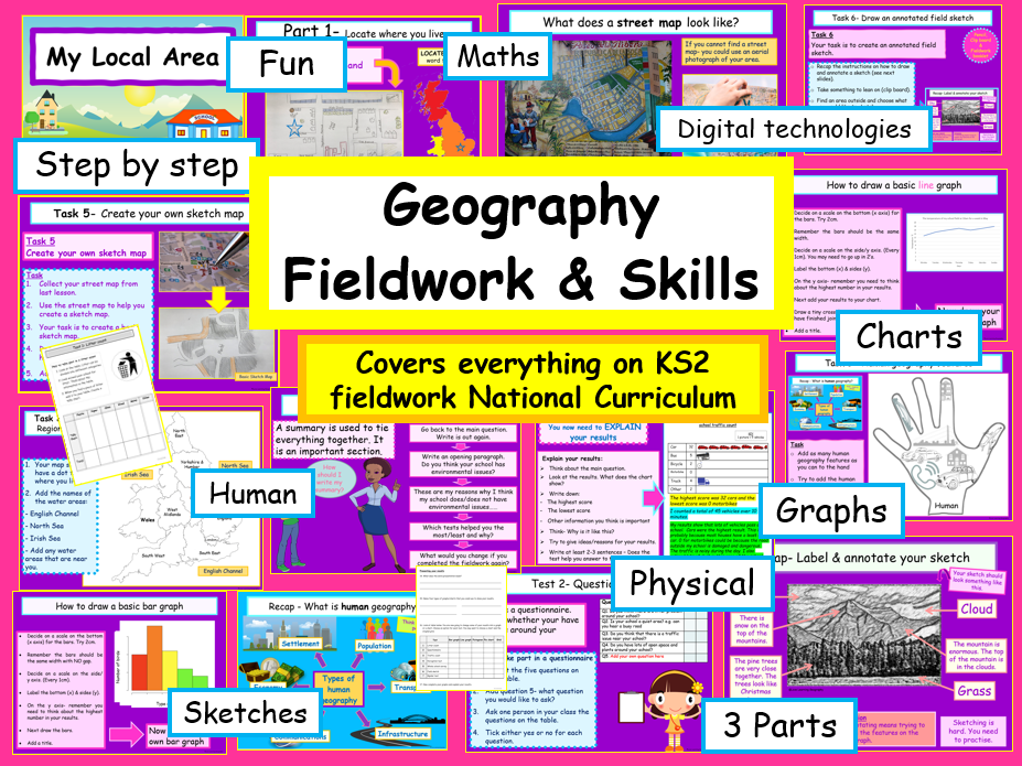
KS2 Fieldwork section of the National Curriculum KS1- The work is divided into 12 sections KS2- The work is divided into 16 sections. Fieldwork- The work is divided into 3 sections. There are animated & interactive vibrant power points, maps, worksheets, starters, recaps/plenaries, basic lesson plan, IT activities & fieldwork opportunities. Each power point can be adapted to meet the needs of your learners. Previews available on my Love Learning Facebook Page. This will save you so much time. It is easy to follow and will help students build their confidence in geography. You can teach the sections at your own pace and the ppts can be easily tweaked to your class. The fieldwork booklet is in pdf. The two SOW have taken me over 250 hours to create everything. My aim is to improve the transition from primary to secondary geography. Suitable for a non-specialist. To help SEN students I have included a variety of learning styles. All font is in Comic sans, to support dyslexic learners. The scheme of work can be easily adapted to meet the needs of higher-level learners. There are two differentiated assessments. An interim assessments. A student revision exam poster. Also includes IT activities and fieldwork opportunities. Thank you for looking at my resources. If you download or purchase any of my resources, I would really appreciate the feedback. I would love to hear from you! *I hope your students love learning geography :) * T&C By purchasing my resources, you are agreeing that the contents are the property of Love Learning Geography and licensed to you only for classroom/personal use as a single user. I retain copyright and reserve all rights to this product. You are not permitted to resell or share this item. You may not share it anywhere online (except on secure platforms with your own students).
Primary Geography Fieldwork KS2
LovelearninggeographyLovelearninggeography

Primary Geography Fieldwork KS2

(1)
Geography Fieldwork In My Local Area Everything you need to cover the Key Stage 2 Fieldwork section of the National Curriculum. Great for KS3 recap or foundation. I have also included some geographical skills. The work is divided into 3 sections. Includes: animated & interactive vibrant power points, identification card, worksheets, guidance grid and IT activities . I have also added some free improvement stickers. Each power point can be adapted to meet the needs of your learners. This pack would also be suitable for KS3 if your students have not covered fieldwork in their primary school. This will save you so much time. It is easy to follow and will help students build their confidence in geography. You can teach the sections at your own pace and the ppts can be easily tweaked to your class. The booklet is in pdf. My aim is to improve the transition from primary to secondary geography. Suitable for a non-specialist. To help SEN students I have included a variety of learning styles. All font is in Comic sans, to support dyslexic learners. The ppts can be easily adapted to meet the needs of higher-level learners. The 3 sections are: Part 1 –Locate where you live and create a sketch map Part 2- Look at the physical & human features in your area & create an annotated sketch map Part 3- Take part in a geography fieldwork investigation What is included? • Locate where you live • Find out what region you live in • Use atlases • Use local maps and plans • What does a street map/plan look like? • How to create a sketch map • Use a range of digital technologies • How to create improvement stickers • Recap human and physical features • Look at the physical geography in your local area • Carry out a bird identification survey • How to create a bar graph • Observing, measuring and recording temperature and rainfall • How to draw a line graph • Discover the types of human features around your school • How to draw annotated field sketch from a photograph • Observing, measuring, recording and presenting human and physical features • What is environmental geography? • Take part in a geography investigation • How do I plan and investigation? • Locate your school on a map • What is a method and how do you use it? • A range of methods/tests – Litter count, questionnaire, traffic count, perception test, whole school survey, field sketch and bipolar test • Examples of how to present and describe the results • Summary/Conclusion of the investigation Sources:Pixabay (unless stated) © Love Learning Geography See a preview on my Facebook & Instagram page- link in bio Students will have all the fieldwork knowledge they need to start key stage 3 geography. I have also created the full scheme of work for Key Stage 2 (physical geography). Thank you for looking at my resources. If you download or purchase any of my resources, I would really appreciate the feedback. I would love to hear from you! *I hope your students love learning geography :) *
Front Page Tracking Assessment  Sheets
LovelearninggeographyLovelearninggeography

Front Page Tracking Assessment Sheets

(1)
Hi, I thought that this may be useful. It is fully editable. It can be used for any subject. Glue in the front of the class book and fill in the information as you go. If you have the time to show your appreciation and click 5 stars…it is really helpful for me to see what resources people need. It also makes me so happy that I am helping teachers reduce their work load. ©Love Learning Geography I will be uploading lots of Free resources this year. The easiest way to follow me in on my Facebook & Instagram page- link in bio I hope your children love learning geography :)
Geography National Curriculum Primary KS1 & KS2
LovelearninggeographyLovelearninggeography

Geography National Curriculum Primary KS1 & KS2

2 Resources
Primary Geography Key Stage One & Two bundle Full KS1 Geography National Curriculum Full KS2 Physical Geography National Curriculum KS1- The work is divided into 12 sections KS2- The work is divided into 16 sections. Details on each bundle. There are animated & interactive vibrant power points, maps, worksheets, starters, recaps/plenaries, basic lesson plan, IT activities & fieldwork opportunities. Each power point can be adapted to meet the needs of your learners. This will save you so much time. It is easy to follow and will help students build their confidence in geography. You can teach the sections at your own pace and the ppts can be easily tweaked to your class. The two SOW have taken me over 210 hours to create everything. My aim is to improve the transition from primary to secondary geography. Suitable for a non-specialist. To help SEN students I have included a variety of learning styles. All font is in Comic sans, to support dyslexic learners. The scheme of work can be easily adapted to meet the needs of higher-level learners. There are two differentiated assessments. An interim assessments. A student revision exam poster. Also includes IT activities and fieldwork opportunities. I hope your students love learning geography :) T&C By purchasing my resources, you are agreeing that the contents are the property of Love Learning Geography and licensed to you only for classroom/personal use as a single user. I retain copyright and reserve all rights to this product. You are not permitted to resell or share this item. You may not share it anywhere online (except on secure platforms with your own students).
Physical Geography KS2 Whole Scheme of Work
LovelearninggeographyLovelearninggeography

Physical Geography KS2 Whole Scheme of Work

(5)
Primary Geography Key Stage Two SOW National Curriculum I have included everything you need to cover the Key Stage 2 Physical Geography National Curriculum. The work is divided into 16 sections. There are animated & interactive vibrant power points, maps, worksheets, starters, recaps/plenaries, basic lesson plan, IT activities & fieldwork opportunities. Each power point can be adapted to meet the needs of your learners. This will save you so much time. It is easy to follow and will help students build their confidence in geography. You can teach the sections at your own pace and the ppts can be easily tweaked to your class. The SOW has taken me over 120 hours to create everything. My aim is to improve the transition from primary to secondary geography. Suitable for a non-specialist. To help SEN students I have included a variety of learning styles. All font is in Comic sans, to support dyslexic learners. The scheme of work can be easily adapted to meet the needs of higher-level learners. There are two differentiated assessments. An interim assessment at the end of section 5 and after section 15. A student revision exam poster. Also includes IT activities and fieldwork opportunities. Includes: • Facts about the Northern and Southern Hemispheres • Locate the Equator & Prime/Greenwich Meridian • Use atlases, globes and maps • Use longitude and latitude • Locate the Tropics of Cancer & Capricorn, Arctic & Antarctic Circle • Study different time zones • Use maps, globes & atlases to locate countries • Describe and explain key physical aspects • Locate the world’s countries, using maps to focus on Europe • Create an annotated field sketch • Recap and develop physical geography knowledge • Study physical geography in the UK • Develop bar graph skills • Cover world climate zones • Complete monitoring the weather fieldwork • Look at polar, temperate, and tropical climate zones • Identify a habitat, an ecosystem, a biome & a vegetation belt • Identify key physical characteristics & topographical features • Cover natural hazards • Physical features in Europe • Use 4-figure grid references • Locate countries in North and South America • Describe the water cycle • Compare geographical similarities and differences (UK, Italy & Brazil) • Case studies – UK, Italy, and Brazil • Complete the ks2 physical geography exam • Learn new key geographical words • IT activities Sources:Pixabay (unless stated) © Love Learning Geography Students will have everything they need to start key stage 3 physical geography. I have also created the full scheme of work for Key Stage 1. Thank you for looking at my resources. If you download or purchase any of my resources, I would really appreciate the feedback. I would love to hear from you! *I hope your students love learning geography :) *
UK Countries & Capital Cities
LovelearninggeographyLovelearninggeography

UK Countries & Capital Cities

(0)
Geography Power Point the UK & Capital Cities This lesson is about Countries in the UK & Capital cities. It is suitable for ks1 & ks2 students. The information is easy to follow and is suitable for a non-specialist teachers/parents. The resources are vibrant, interesting and have fun activities. Ask your school to purchase this ready to use resource now and take control of your workload. What will your students learn: • What is a country? • What is a city? • What is a capital city? • The UK capital cities • Name the water areas around the UK • Mapwork • IT activity Includes: • An Interactive Power Point presentation • Student Work Sheet • Basic Lesson Plan • Sources: Pixabay, Upsplash & Pexels • ©Love Learning Geography The resources will help support student’s learning, development, and attainment. Student’s will gain more confidence and develop their geographical knowledge and skills. The power point can be used on a white board or with a projector. It has animations and moving objects. To help SEN students, I have included a variety of learning styles. All font is in Comic sans, to support dyslexic learners. The power points can be easily adapted to meet the needs of higher-level learners. Thank you for looking at my resources. If you like my style, then follow me. I will be adding lots of new resources throughout the year. If you download or purchase any of my resources, I would really appreciate feedback. I would love to hear from you! I hope your class loves learning with my resources :) T&C By purchasing my resources, you are agreeing that the contents are the property of Love Learning Geography and licensed to you only for classroom/personal use as a single user. I retain copyright and reserve all rights to this product. You are not permitted to resell or share this item. You may not share it anywhere online (except on secure platforms with your own students).
Longitude Latitude  & Time Zones Bundle
LovelearninggeographyLovelearninggeography

Longitude Latitude & Time Zones Bundle

2 Resources
The World divided into Hemispheres & Meridians using globes & maps Two lessons about latitude, longitude, time zones, & GPS and is suitable for KS2 and foundation KS3 children. The power point information is easy to follow and is suitable for a non-specialist teachers/parents. The resources are vibrant, interesting and have fun activities. An ideal resource to teach before longitude & latitude. What your children will learn: Part 1 • Recap globes & maps, continents, oceans & compass directions • How is the world divided up • What are Hemispheres? • What is the Equator? • What are Meridians? • What is the Prime Meridian? Part 2 • Recap Continents, Hemispheres & Meridians • What is GPS (Geographical Positioning Systems) • What is longitude & latitude? • Locate the Arctic Circle, Tropic of Cancer/Capricorn & Antarctic circle • What is the Prime Meridian? • How to find longitude and latitude on a map? • What is the Prime Meridian? • What are time zones? Includes: • Two animated & Interactive Power Point presentations • Student Work Sheets • Basic lesson plan • Sources: Pixabay, Upsplash & Pexels • ©Love Learning Geography The resources will help support student’s learning, development, and attainment. Student’s will gain more confidence and develop their geographical knowledge and skills. The power point can be used on a white board or with a projector. It has animations and moving objects. To help SEN students, I have included a variety of learning styles. All font is in Comic sans, to support dyslexic learners. The power points can be easily adapted to meet the needs of higher-level learners. Thank you for looking at my resources.If you download or purchase any of my resources, I would really appreciate feedback. I would love to hear from you! Take a look at my new website. Follow me on Instagram & Facebook. Link in bio. I hope your class loves learning with my resources :) T&C By purchasing my resources, you are agreeing that the contents are the property of Love Learning Geography and licensed to you only for classroom/personal use as a single user. I retain copyright and reserve all rights to this product. You are not permitted to resell or share this item. You may not share it anywhere online (except on secure platforms with your own students).
Longitude Latitude & Time Zones
LovelearninggeographyLovelearninggeography

Longitude Latitude & Time Zones

(0)
This lesson is about Hemispheres, Meridians, Latitude, Longitude, Time Zones, & GPS and is suitable for KS2 and foundation KS3 children. This lesson is quite difficult to teach so I have created a resource that is easy to follow. The power point information is easy to follow and is suitable for a non-specialist teachers/parents. The resources are vibrant, interesting and have fun activities. An ideal resource to teach before longitude & latitude. What will your students learn: • Recap Continents, Hemispheres & Meridians • What is GPS (Geographical Positioning Systems) • What is longitude & latitude? • Locate the Arctic Circle, Tropic of Cancer/Capricorn & Antarctic circle • What is the Prime Meridian? • How to find longitude and latitude on a map? • What is the Prime Meridian? • What are time zones? Includes: • An Interactive PowerPoint presentation • Student Work Sheet • Basic lesson plan • Sources: Pixabay, Upsplash & Pexels • ©Love Learning Geography Follow my Facebook & Instagram page- link in bio The resources will help support student’s learning, development, and attainment. Student’s will gain more confidence and develop their geographical knowledge and skills. The power point can be used on a white board or with a projector. It has animations and moving objects. To help SEN students, I have included a variety of learning styles. All font is in Comic sans, to support dyslexic learners. The power points can be easily adapted to meet the needs of higher-level learners. By purchasing my resources, you are agreeing that the contents are the property of Love Learning Geography and licensed to you only for classroom/personal use as a single user. I retain copyright and reserve all rights to this product. You are not permitted to resell or share this item. You may not share it anywhere online (except on secure platforms with your own students). Thank you for looking at my resources. If you download or purchase any of my resources, I would really appreciate feedback. I would love to hear from you! Take a look at my new website- Link on main page. Follow me on Instagram & Facebook. I hope your class loves learning with my resources :)
World Geography Hemispheres & Prime Meridian
LovelearninggeographyLovelearninggeography

World Geography Hemispheres & Prime Meridian

(1)
A World Divided into Hemispheres & Meridians This lesson is about world geography & how it is divided by maps & globes and is suitable for KS2 and foundation KS3 students. The power point information is easy to follow and is suitable for a non-specialist teachers/parents. The resources are vibrant, interesting and have fun activities. An ideal resource to teach before longitude & latitude. Ask your school to purchase this ready to use ppt now and take control of your workload. What will your students learn: • Recap globes & maps, continents, oceans & compass directions • How is the world divided up • What are Hemispheres? • What is the Equator? • What are Meridians? • What is the Prime Meridian? Includes: • An Interactive PowerPoint presentation • Student Work Sheets • Sources: Pixabay, Upsplash & Pexels • ©Love Learning Geography The resources will help support student’s learning, development, and attainment. Student’s will gain more confidence and develop their geographical knowledge and skills. The power point can be used on a white board or with a projector. It has animations and moving objects. To help SEN students, I have included a variety of learning styles. All font is in Comic sans, to support dyslexic learners. The power points can be easily adapted to meet the needs of higher-level learners. Thank you for looking at my resources. If you download or purchase any of my resources, I would really appreciate feedback. I would love to hear from you! I hope your class loves learning with my resources :) T&C By purchasing my resources, you are agreeing that the contents are the property of Love Learning Geography and licensed to you only for classroom/personal use as a single user. I retain copyright and reserve all rights to this product. You are not permitted to resell or share this item. You may not share it anywhere online (except on secure platforms with your own students).
WORD MATS Weather Climate Rivers & Coasts
LovelearninggeographyLovelearninggeography

WORD MATS Weather Climate Rivers & Coasts

(0)
Geography Ks1 & Ks2 Literacy Key Word Physical Geography Mats This geography resource pack has 2 literacy word mats and is suitable for ks1 & foundation ks2 students. The resources are vibrant and clear. The colourful mats help students with their spelling. Learn new keywords and start discussions. They look amazing in colour, double sided and laminated. What will your students learn: • The keywords needed for Key Stage 1 & 2 • Key Stage 1 & 2 Physical Geography Spellings Includes: • Two vibrant pdf Word Mats • Sources: Pixabay, Upsplash & Pexels • ©Love Learning Geography The resources will help support student’s learning, development, and attainment. Student’s will gain more confidence and develop their geographical knowledge and skills. To help SEN students the font is in Comic sans, to support dyslexic learners. Thank you for looking at my resources. If you download or purchase any of my resources, I would really appreciate feedback. I would love to hear from you! ***I hope your class loves learning with my resources :) *
Analysing Graphs & Charts WORD MATS
LovelearninggeographyLovelearninggeography

Analysing Graphs & Charts WORD MATS

(0)
**An ideal resource for blending Numeracy / Maths & Geography. The literacy word mats and is suitable for ks2 ks3 and foundation ks4 students. ** The sentences starters will help students become more confident in analysing graphs. The resources are vibrant and clear. The colourful pdf mats help students with their spelling and how to correctly annotate graphs and charts… Learn new keywords and start discussions. They look amazing in colour, double sided and laminated. What will your students learn: • The keywords needed for Analysing Graphs & Charts • Key Stage 2 & 3 Spellings Includes: • Two Word Mats • Sources: Pixabay, Upsplash & free Clip Art • ©Love Learning Geography The resources will help support student’s learning, development, and attainment. Student’s will gain more confidence and develop their geographical knowledge and skills. To help SEN students the font is in Comic sans, to support dyslexic learners. Thank you for looking at my resources. If you download or purchase any of my resources, I would really appreciate feedback. I would love to hear from you! I hope your class loves learning with my resources :)