I've worked in primary teaching for over 10 years and specialise in creating fun and engaging educational resources, particularly for Geography and History.
I've worked in primary teaching for over 10 years and specialise in creating fun and engaging educational resources, particularly for Geography and History.
Our World is a comprehensive Geography topic about Planet Earth, suitable for KS1 and lower KS2 (Y1-3).
The planning overview, topic title page and vocabulary page can be downloaded for free here. Lessons include:
L1 – Completing a world map jigsaw
L2 – Identifying the continents and oceans of the world (FREE)
L3 – Where do we live?
L4 – Identifying human and natural features of the world
L5 – Investigating satellite photos of famous world landmarks
L6 – Introduction to compass directions
L7 – Identifying world climate zones
L8 – Identifying the countries and capitals of the UK (FREE)
Each lesson includes a presentation and differentiated activities/worksheets.
If you like this resource, we would appreciate a review! We will happily send you a free resource in return for a review or useful suggestions/feedback. Contact us at ed@teachitforward.co.uk.
This is the free planning overview for Our World, a comprehensive introduction to the geography of Planet Earth. A vocabulary page and topic title page are also included.
This unit is designed for students in KS1 and lower KS2 (Y1-3) and includes a variety of engaging lessons, differentiated activities and worksheets.
All the resources described in the planning are available on TES, either individually or as a bundle. Lessons include:
L1 – Completing a world map jigsaw
L2 – Identifying the continents and oceans of the world (FREE)
L3 – Where do we live?
L4 – Identifying human and natural features of the world
L5 – Investigating satellite photos of famous world landmarks
L6 – Introduction to compass directions
L7 – Identifying world climate zones
L8 – Identifying the countries and capitals of the UK (FREE)
If you like this resource, we would appreciate a review! We will happily send you a free resource in return for a review or useful suggestions/feedback. Contact us at ed@teachitforward.co.uk.
This lesson is part of Our World, a Geography unit designed for students in KS1 and lower KS2 (Y1-3), but can also be taught as a stand alone lesson.
This Geography lesson is a fun introduction to satellite photos. The presentation first helps students understand what satellite photos are. It then challenges them to investigate satellite photos of a variety of world famous human and natural landmarks (e.g. Eiffel Tower, Victoria Falls).
It is accompanied by two activities:
Speaking and Listening Activity
In mixed pairs or trios, students match the photos of 16 world famous landmarks to their satellite photos, explaining their reasoning as they do so.
Writing Activity
Students investigate satellite photos and write sentences explaining which landmark they think each one is. E.g. “I think this photo is Stonehenge because I can see a circle of huge stones surrounded by grass.”
If you like this resource, we would appreciate a review! We will happily send you a free resource in return for a review or useful suggestions/feedback. Contact us at ed@teachitforward.co.uk.
This lesson is an ideal introduction to the world’s three main climate zones.
It is part of Our World, a Geography unit designed for students in KS1 and lower KS2 (Y1-3), but can also be taught as a stand alone lesson.
First the presentation helps students understand that different places in the world have different climates. It then looks at the location of the Equator and North/South poles, and how these relate to the three main climate zones. To keep things simple, these are referred to as hot (tropical), mild (temperate) and cold (frigid).
The activity challenges students to locate the Equator and poles and then identify various climate zones around the world. It is differentiated two ways:
Easier – Students identify the climate zone of 8 numbered points around the world.
Harder – Students identify climate zone and continent of 8 numbered points around the world.
Extension – Students cut and stick pictures of four animals – elephant, lion, polar bear and penguin – onto their world climate zone map.
If you like this resource, we would appreciate a review! We will happily send you a free resource in return for a review or useful suggestions/feedback. Contact us at ed@teachitforward.co.uk.
This lesson is part of Our World, a Geography unit designed for students in KS1 and lower KS2 (Y1-3), but can also be taught as a stand alone lesson.
It aims to help younger students understand where they live. It looks at where Earth is in the solar system and then which continent, country and place they call home.
In the activity students write sentences about where they live. There are two differentiated worksheets:
Easier – Students fill in cloze procedure sentences to describe where they live.
Harder – Students write full sentences to describe where they live.
Extension – Students sort the names of countries, continents and planets into the correct categories.
If you like this resource, we would appreciate a review! We will happily send you a free resource in return for a review or useful suggestions/feedback. Contact us at ed@teachitforward.co.uk.
This lesson is part of Our World, a Geography unit designed for students in KS1 and lower KS2 (Y1-3), but can also be taught as a stand alone lesson.
The presentation first helps students understand the concepts of ‘human’ and ‘natural’. It then takes them on a journey around the world and challenges them to identify human and natural features of our planet (e.g. mountains, airports).
There are two associated activities:
Group activity:
Students match pictures of features of the world to their names and sort them into human and natural categories.
Individual activity:
Children identify photos of features of the world.
Easier – Students identify features of the world (no writing).
Harder – Students identify features of the world (writing).
Extension – Students label each feature as human (H) or natural (N).
If you like this resource, we would appreciate a review! We will happily send you a free resource in return for a review or useful suggestions/feedback. Contact us at ed@teachitforward.co.uk.
This lesson is part of Exploring the United Kingdom, a Geography unit designed for KS1 and lower KS2 (Y2-4).
The presentation first introduces students to satellite photos before going on to challenge them to match satellite photos to famous UK landmarks (e.g. Wembley Stadium, Edinburgh Castle).
In the activity, students use their geography detective skills to describe satellite photos and infer which famous UK landmark or feature each one is. It is differentiated two ways:
Easier – Students write description of each satellite photo on a writing template sheet.
Harder – Students stick satellite photos into their exercise book and write descriptions next to them.
If you like this resource, we would appreciate a review! We will happily send you a free resource in return for a review or useful suggestions/feedback. Contact us at ed@teachitforward.co.uk.
This lesson is an ideal introduction to compass directions for younger children.
It is part of Our World, a Geography unit designed for students in KS1 and lower KS2 (Y1-3), but can also be taught as a stand alone lesson.
The presentation introduces the four cardinal points of the compass (North, East, South and West). It then challenges students to describe the position of objects using these compass directions.
The activity worksheets are differentiated two ways:
Easier – Students describe the position of objects using compass directions (simple questions).
Harder – Students describe the position of objects using compass directions (mixed questions).
Extension – Students fill in the blanks on a compass using different vocabulary.
If you like this resource, we would appreciate a review! We will happily send you a free resource in return for a review or useful suggestions/feedback. Contact us at ed@teachitforward.co.uk.
This fun jigsaw activity is a great geography resource for reinforcing children’s knowledge of the world.
It is also available as part of the Our World topic, an introduction to the geography of Planet Earth for KS1 and lower KS2
The presentation introduces students to a map of the world and highlights physical features including the continents, oceans, rivers and mountain ranges.
The jigsaw puzzle activity is differentiated six ways. The age brackets below are a rough guide:
6 pieces – EYFS
12 pieces – EYFS/Y1
24 pieces – Y1/2/3
36 pieces – Y2/3/4
48 pieces – Y3/4/5
60 pieces – Y4/5/6
A guide map is included for students in Early Years and KS1. Challenge more able KS2 students to complete the puzzle without the guide map.
If you like this resource, we would appreciate a review! We will happily send you a free resource in return for a review or useful suggestions/feedback. Contact us at ed@teachitforward.co.uk.
This is a simple matching activity to help children recognise and identify the continents of the world. It is suitable for children in KS1 & KS2.
This resource works well with the World map jigsaw and Continents and oceans of the world.
It can also be used to play Pelmanism, a fun game which promotes concentration and memory skills.
If you like this resource, we would appreciate a review! We will happily send you a free resource in return for a review or useful suggestions/feedback. Contact us at ed@teachitforward.co.uk.
This free lesson is an ideal introduction to the geography of the British Isles for students in KS1 and KS2. It is also part of Exploring the United Kingdom, a Geography unit designed for KS1 and lower KS2 (Y2-4).
The colourful presentation teaches students the countries, capitals and seas of the United Kingdom and Ireland. The activity worksheets are differentiated four ways:
Easier – Students identify the countries & capitals of the UK and Ireland (with a map prompt).
Medium – Students identify the countries & capitals of the UK and Ireland (with vocab & map prompt).
Harder – Students identify the countries & capitals of the UK and Ireland (with vocab but no map prompt).
Hardest – Students identify the countries, capitals and seas of the UK and Ireland (no vocab or map prompt).
If you like this resource, we would appreciate a review! We will happily send you a free resource in return for a review or useful suggestions/feedback. Contact us at ed@teachitforward.co.uk.
This is the free planning overview for Exploring the United Kingdom, a comprehensive unit of work about the geography of the UK. A vocabulary page and topic title page are also included.
This unit is designed for students in KS1 and lower KS2 and includes nine fully-planned lessons complete with differentiated activities and worksheets.
All the resources described in this unit plan are available on TES, either as individual lessons or as a bundle. Lessons include:
L1 – Identifying the countries and capitals of the UK & Ireland (FREE)
L2 – Locating UK cities using compass directions
L3 – Identifying human & physical features of the UK
L4 – Investigating satellite photos of the UK
L5 – Comparing the city and the countryside
L6– Identifying famous features and characteristics of countries of the UK
L7 – Identifying flags of the United Kingdom
L8 – Identifying the four seasons of weather in the UK
Optional lesson – Identifying the countries and capital cities of Europe
If you like this resource, we would appreciate a review! We will happily send you a free resource in return for a review or useful suggestions/feedback. Contact us at ed@teachitforward.co.uk.
Exploring the UK is a Geography unit suitable for KS1 and lower KS2 (Y2-4).
The planning overview, topic title page and vocabulary page can be downloaded for free here. Lessons include:
L1 – Identifying the countries and capitals of the UK & Ireland (FREE)
L2 – Locating UK cities using compass directions
L3 – Identifying human & physical features of the UK
L4 – Investigating satellite photos of the UK
L5 – Comparing the city and the countryside
L6– Identifying famous features and characteristics of countries of the UK
L7 – Identifying flags of the United Kingdom
L8 – Identifying the four seasons of weather in the UK
Optional lesson – Identifying the countries and capital cities of Europe
Each lesson includes a presentation and differentiated activities/worksheets.
If you like this resource, we would appreciate a review! We will happily send you a free resource in return for a review or useful suggestions/feedback. Contact us at ed@teachitforward.co.uk.
This lesson is part of Exploring the United Kingdom, a Geography unit designed for KS1 and lower KS2 (Y2-4).
In the lesson, students learn about the four seasons and characteristics associated with each. First they have to guess each season using different clues. They then find out about the different types of weather associated with each season.
The colourful activity is differentiated three ways:
Easier – Students match 16 pictures (with labels) to the seasons.
Medium – Students match 20 pictures (with labels) to the seasons.
Harder – Students match 20 pictures to the seasons and label them.
If you like this resource, we would appreciate a review! We will happily send you a free resource in return for a review or useful suggestions/feedback. Contact us at ed@teachitforward.co.uk.
This lesson is part of Exploring the United Kingdom, a Geography unit designed for KS1 and lower KS2 (Y2-4).
First the presentation introduces children to the flags of the United Kingdom and their names.
Students then complete one of two differentiated activity worksheets:
Easier – Students complete cloze procedure sentences about UK flags (with clues)
Harder – Students complete cloze procedure sentences about UK flags (no clues)
Extension – Students colour in the three UK national flags which together make up the Union Jack.
If you like this resource, we would appreciate a review! We will happily send you a free resource in return for a review or useful suggestions/feedback. Contact us at ed@teachitforward.co.uk.
This lesson is part of Exploring the United Kingdom, a Geography unit designed for KS1 and lower KS2 (Y2-4).
The presentation first explains how every country – just like people – has its own special features and characteristics. It then introduces a variety of famous UK landmarks, sports and foods and challenges students to work out whether each is from England, Scotland, Wales or Northern Ireland.
The activity can be done in two ways:
Partner activity:
In mixed ability partners, students match 20 features and characteristics to the four UK countries.
Individual activity:
Students match 20 features/characteristics to the four UK countries.
Easier – Students match features/characteristics to each country (using stickers with labels).
Harder – Students match features/characteristics to each country and label each one (using stickers without labels).
If you like this resource, we would appreciate a review! We will happily send you a free resource in return for a review or useful suggestions/feedback. Contact us at ed@teachitforward.co.uk.
This lesson is part of Exploring the United Kingdom, a Geography unit designed for KS1 and lower KS2 (Y2-4).
This lesson encourages students to identify geographical features found in the city/countryside and think about the similarities and differences between urban and rural areas in the UK.
First the presentation shows small segments of images from around the United Kingdom and challenges students to work out whether they are from the city or countryside.
Children then complete a Venn diagram-based activity which can be done in two ways:
Group activity:
In pairs or trios, children sort images of the city and countryside using a Venn diagram. This can also be done using two PE hoops and makes a nice classroom display.
Individual activity:
Students sort city and countryside vocabulary using a Venn diagram:
Easier – Students sort 12 city/countryside words
Harder – Students sort 18 city/countryside words
If you like this resource, we would appreciate a review! We will happily send you a free resource in return for a review or useful suggestions/feedback. Contact us at ed@teachitforward.co.uk.
This lesson is part of Exploring the United Kingdom, a Geography unit designed for KS1 and lower KS2 (Y2-4).
The presentation helps students understand the difference between human and physical geographical features. It then challenges them to classify famous UK landmarks as either human or physical.
There are two engaging activities included:
Partner activity:
Students sort pictures/descriptions of UK landmarks into human and physical geographical features.
Individual activity:
Students match pictures of UK landmarks to their descriptions. This is differentiated three ways:
Easier – Students match 8 features to their descriptions.
Medium – Students match 12 features to their descriptions.
Harder – Students write a description of each UK landmark using a word bank.
Extension – Students sort the UK landmarks into human and physical geographical features.
If you like this resource, we would appreciate a review! We will happily send you a free resource in return for a review or useful suggestions/feedback. Contact us at ed@teachitforward.co.uk.
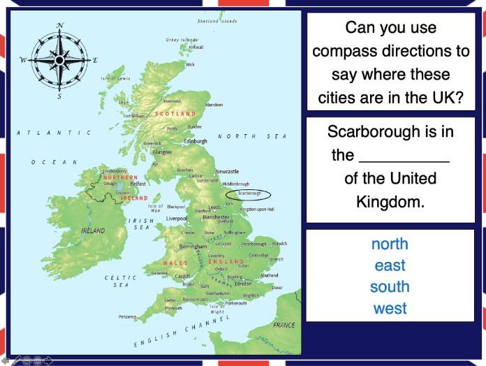
This lesson is part of Exploring the United Kingdom, a Geography unit designed for KS1 and lower KS2 (Y2-4).
N.B. If students are new to compass directions, use Introduction to compass directions to introduce the topic prior to this lesson.
First the presentation reminds students of the four cardinal compass directions. It then encourages them to use compass directions to describe the position of towns and cities around the UK.
In the activity, students have to find UK cities using compass clues. There are two differentiated activity worksheets:
Easier – Students locate cities using compass clues and starting letter clues.
Harder – Students locate cities using compass and harder starting letter clues.
Extension – Students complete cloze procedure sentence about the location of cities in the UK.
If you like this resource, we would appreciate a review! We will happily send you a free resource in return for a review or useful suggestions/feedback. Contact us at ed@teachitforward.co.uk.
This fun Literacy activity challenges children to unscramble sentences about the Great Fire of London. It is part of a KS1 History unit called Great Fire of London, also available on TES.
The lesson is a great way to encourage children to think about sentence structure and develop early editing skills. The activity includes three differentiated worksheets and an extension:
LA - Scrambled sentences with capital letters and full-stops.
MA - Scrambled sentences with no capital letters and full-stops.
UA - Trickier scrambled sentences with no capital letters and full-stops.
Extension - Children edit three sentences about the Great Fire of London.
If you like this resource, we would appreciate a review! We will happily send you a free resource in return for a review or useful suggestions/feedback. Contact us at ed@teachitforward.co.uk.