Thank you for visiting! Here you will find a selection of printable, interactive worksheets for your classroom: Basic Geography worksheets with simple maps, ESL, Spanish, Bible, Reading Comprehension and more. I hope you find the resources useful! Reviews are welcome and very much appreciated. Thank you so much.
Thank you for visiting! Here you will find a selection of printable, interactive worksheets for your classroom: Basic Geography worksheets with simple maps, ESL, Spanish, Bible, Reading Comprehension and more. I hope you find the resources useful! Reviews are welcome and very much appreciated. Thank you so much.
Introduce your learners to Kenya with two worksheets (plus answer key). Your students will read a brief introduction to Kenya (location, capital, flag, language), write ‘Nairobi’ next to the star on the map to show the location of the capital, trace the line of the equator across Kenya, color the small map and flag, and use the map and compass to answer 9 questions on page 2. Colored pencils and a pen or pencil are needed for this activity. No other prep needed. Basic Geography worksheet with a simple map to introduce Kenya and practice cardinal and ordinal directions.
For use with Interactive Notebooks: After the worksheets are completed, students can cut out the map and flag and paste into the notebook under the topic of Africa / Sub-Topic: Kenya. Under the map and flag, students can write a summary in their own words of what they now know about this country. Collect worksheets for other countries of Africa to add to the notebook! Please browse this store for a selection of worksheets for other countries of Africa (and beyond!).
Thank you so much for using my Geography worksheets in your classroom! Reviews are welcome and very much appreciated.
Using the map, find the 17 regions of Spain in the Word Search Puzzle. 1 printable word search puzzle with map (plus answer key).
Regions of Spain to find in Word Search Puzzle:
Andalucía
Aragon
Asturias
Balearic Islands
Basque Country
Canary Islands
Cantabria
Castilla-La Mancha
Castilla Y Leon
Catalonia
Extremadura
Galicia
La Rioja
Madrid
Murcia
Navarra
Valencia
Thank you so much for using my worksheets in your classroom! I hope you find them useful. Reviews are welcome and very much appreciated! Please browse this store for a selection of Geography worksheets, word search puzzles and more!
Introduce your students to the 18 regions and capital cities of France with three worksheets (plus answer key). Using the list of regions and capitals of France on page 2, your students will write the capital city of each region on the map of France (page 1). Then answer 8 true/false questions on page 3.
Regions - Capitals included:
Auvergne-Rhône-Alpes - Lyon
Bourgogne-Franche-Comté - Dijon
Bretagne - Rennes
Centre-Val de Loire - Orléans
Corse - Ajaccio
Grand Est - Strasbourg
Hauts-de-France - Lille
Ile-de-France - Paris
Normandie - Rouen
Nouvelle-Aquitaine - Bordeaux
Occitanie - Toulouse
Pays de la Loire - Nantes
Provence–Alpes–Côte d’Azur - Marseille
Guadeloupe - Basse-Terre
Guyane - Cayenne
La Réunion - Saint-Denis
Martinique - Fort-de-France
Mayotte - Mamoudzou
Thank you so much for using my worksheets in your classroom! I hope you find them useful. Reviews are welcome and very much appreciated. Please browse this store for worksheets to introduce your learners to other countries of the world!
Teach your students about Africa with this packet of 7 printable worksheets.
Page 1 is a list of the 54 countries of Africa in alphabetical order.
Page 2 is a map of Africa. Your students will write the name of each country on the map.
Page 3: Word Search: Find African countries A-L.
Page 4: Word Search: Find African countries M-Z.
Pages 5-6: List the 54 countries of Africa A-Z (your students will see how many they can remember on their own before referring to the list and map).
Page 7: Languages of Africa. Fill in the blank.
Thank you for using my Geography worksheets in your classroom!
Color the map of Europe. Printable handout of 1 page includes a map of Europe to color and learn.
Countries of Europe included: Albania, Andorra, Armenia, Austria, Azerbaijan, Belarus, Belgium, Bosnia and Herzegovina, Bulgaria, Croatia, Cyprus, Czech Republic, Denmark, Estonia, Finland, France, Georgia, Germany, Greece, Hungary, Iceland, Ireland, Italy, Kazakhstan, Kosovo, Latvia, Lithuania, Luxembourg, Macedonia, Malta, Moldova, Monaco, Montenegro, Netherlands, Norway, Poland, Portugal, Romania, Russia, San Marino, Serbia, Slovakia, Slovenia, Spain, Sweden, Switzerland, Turkey, Ukraine, United Kingdom, Vatican City.
Thank you for using my Geography worksheets in your classroom! I hope you find them useful. Reviews are welcome and very much appreciated. Please browse this store for a selection of worksheets to introduce your students to the countries of the world!
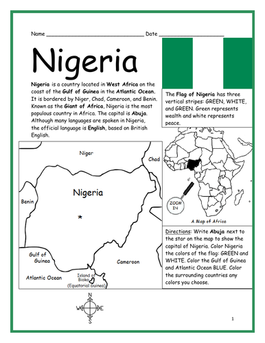
Introduce your students to Nigeria with this printable handout of two worksheets (plus answer key). Your students will read a brief introduction to Nigeria (location, capital, flag, language), write ‘Abuja’ next to the star on the map to show the capital, color the small map, and use the map and compass to answer 8 questions on page 2. Colored pencils and a pen or pencil are needed for this activity. Basic Geography worksheet includes a simple map to introduce the country of Nigeria and practice cardinal/ordinal directions.
For use with Interactive Notebooks: After the worksheets are completed, students can cut out the map and flag and paste into the notebook under the topic of Africa / Sub-topic: Nigeria. Under the map and flag, your students can write a summary in their own words of what they now know about this country. Collect worksheets for other countries of Africa to add to the notebook! Please see this store for a selection of printable worksheets for other countries of Africa (and beyond!).
Thank you so much for using my Geography worksheets in your classroom! I hope you find them useful. Reviews are welcome and very much appreciated!
Using the map of the continent of Oceania, find the 14 island countries in the Word Search Puzzle. They can be found forward or backward. One printable worksheet (plus answer key). Countries included: Australia, Papua New Guinea, New Zealand, Fiji, Solomon Islands, Vanuatu, Samoa, Kiribati, Micronesia, Tonga, Marshall Islands, Palau, Tuvalu, Nauru.
Thank you so much for using my Geography worksheets! I hope you find them useful. Reviews are welcome and very much appreciated. Please browse this store for more Geography worksheets and Word Search Puzzles.
Introduce your students to Spain with two worksheets (plus answer key). Your students will read a brief introduction to Spain (location, capital, flag, language), write ‘Madrid’ next to the star on the map to show the location of the capital, color the flag and map, and use the map and compass to answer 7 questions on page 2. Colored pencils and a pen or pencil are needed for this activity. No other prep needed. Basic Geography worksheet includes a simple map to introduce Spain and practice cardinal/ordinal directions.
For use with Interactive Notebooks: After completing the worksheets, students can cut out the map and flag and paste into the notebook under the topic of Europe (or Spanish-Speaking Countries), Sub-Topic: Spain. Under the map and flag, students can write a summary in their own words of what they now know about this country. Collect worksheets for other countries of Europe to add to the notebook! Please browse this store for a selection of worksheets for other countries of Europe (and beyond!).
Thank you so much for using my worksheets in your classroom! I hope you find them useful. Reviews are welcome and very much appreciated.
Introduce your students to ISRAEL with this printable handout of two worksheets (plus answer key). Your students will read a brief introduction to Israel (location, capital, flag, language), write ‘Jerusalem’ next to the star on the map to show the location of the capital, color the small map, and use the map and compass to answer 9 questions on page 2. Colored pencils and a pen or pencil are needed for this activity. No other prep needed. Basic Geography worksheet with a simple map to introduce Israel and practice cardinal/ordinal directions.
For use with Interactive Notebooks: After the worksheets are completed, students can cut out the map and flag and paste into the notebook under the topic of Asia / Sub-topic: Israel. Under the map and flag, your students can write a summary in their own words of what they now know about Israel. Collect handouts for other countries of Asia to add to the notebook! Please browse this store for a selection of worksheets for all other countries of Asia (and beyond)!
Thank you so much for using my Geography worksheets in your classroom! I hope you find them useful. Reviews are welcome and very much appreciated.
Included: Mediterranean Sea, Red Sea, Dead Sea, Holy Land, Lebanon, Syria, Jordan, Egypt, Saudi Arabia, Tel Aviv, Bethlehem, Nazareth, Palestinian territories West Bank and Gaza, Star of David, Tallit.
Using the map of the Middle East, find the 17 countries in this Word Search Puzzle. They can be found forward or backward. Countries included: Bahrain, Cyprus, Egypt, Iran, Iraq, Israel, Jordan, Kuwait, Lebanon, Oman, Palestine, Qatar, Saudi Arabia, Syria, Turkey, UAE (United Arab Emirates), Yemen. One printable worksheet (plus answer key).
Thank you so much for using my Geography worksheets in your classroom!
Please browse this store for a selection of printable worksheets for each country of the Middle East (and beyond!).
Introduce your students to the country of SOUTH AFRICA with two worksheets (plus answer key). Your students will read a brief introduction to South Africa (location, capitals, flag, language), write ‘Pretoria’ next to the ‘A’ on the map to show the administrative capital; write ‘Bloemfontein’ next to the ‘J’ to show the judicial capital; write ‘Cape Town’ next to the ‘L’ on the map to show the legislative capital, color the small map, and use the map and compass to answer 9 questions on page 2. Basic Geography Worksheet with a simple map to introduce South Africa and practice cardinal and ordinal directions. Colored pencils and a pen or pencil are needed for this activity.
For use with Interactive Notebooks: After the worksheets are completed, students can cut out the map and flag and paste into the notebook under the topic of Africa / Sub-Topic: South Africa. Under the map, students can write a summary in their own words of what they now know about this country. Collect worksheets for other countries of Africa to add to the notebook! Please browse this store for a selection of worksheets for other countries of Africa (and beyond!).
Thank you so much for using my Geography worksheets in your classroom! I hope you find them useful. Reviews are welcome and very much appreciated.
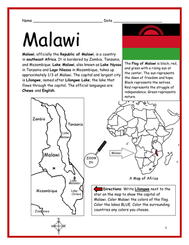
Introduce your students to MALAWI in Africa with this printable handout of two worksheets (plus answer key). Your students will read a brief introduction to Malawi (location, capital, flag, language), write ‘Lilongwe’ next to the star on the map to show the capital, color the small map, and use the map and compass to answer 7 questions on page 2. Colored pencils and a pen or pencil are needed for this activity. No other prep needed. Basic Geography worksheet includes a simple map to introduce the country of Malawi and practice cardinal/ordinal directions.
For use with Interactive Notebooks: After the worksheets are completed, students can cut out the map and flag and paste into the notebook under the topic of Africa/Sub-topic: Malawi. Under the map and flag, your students can write a summary in their own words of what they now know about this country. Collect worksheets for other countries of Africa to add to the notebook! Please browse this store for a selection of printable worksheets for other countries of Africa (and beyond!).
Thank you so much for using my Geography worksheets in your classroom! I hope you find them useful. Reviews are welcome and very much appreciated!
Introduce your students to Japan with this printable handout of two worksheets (plus answer key). Your students will read a brief introductin to Japan (location, capital, flag, language), write ‘Tokyo’ next to the star on the map to show the location of the capital, color the small map and flag, and use the map and compass to answer 7 questions on page 2. Colored pencils and a pen or pencil are needed for this activity. No other prep needed. Basic Geography worksheet with a simple map to introduce Japan and practice cardinal and ordinal directions.
For use with Interactive Notebooks: After the worksheets are completed, students can cut out the map and flag and paste into the notebook under the topic of Asia / Sub-Topic: Japan. Under the map and flag, your students can write a summary in their own words of what they now know about this country. Collect handouts for other countries of Asia to add to the notebook! Please browse this store for a selection of worksheets for all other countries of Asia (and beyond!)
Thank you so much for using my Geography worksheets in your classroom! I hope you find them useful. Reviews are welcome and very much appreciated!
Japanese Archipelago, Islands of Honshu, Hokkaido, Kyushu, Shikoku.
Nisshōki, Hinomaru, Maritime borders. Dialect. Okinawa, Ryukyu Islands.
Introduce your students to Poland with this printable handout of 2 worksheets (plus answer key). Your students will read a brief introduction to Poland (location, capital, flag, language), write 'Warsaw' next to the star on the map to show the location of the capital, color the small map and flag, and use the map and compass to answer 7 questions on page 2. Colored pencils and a pen or pencil are needed for this activity. No other prep needed. Basic Geography worksheet with a simple map to introduce Poland and practice cardinal and ordinal directions.
For use with Interactive Notebooks: After the worksheets for Poland are completed, students can cut out the map and flag and paste into the notebook under the topic of Europe/Sub-Topic: Poland. Under the map, your students can write a summary in their own words of what they now know about Poland. Collect worksheets for other countries of Europe to add to the notebook! Please browse this store for worksheets for other countries of Europe - and beyond!
Thank you so much for using my Geography worksheets in your classroom! I hope you find them useful and fun. Reviews are welcome and very much appreciated!
Introduce your students to the Netherlands (Holland) with two worksheets (plus answer key). Your students will read a brief introduction to the Netherlands (location, capital, flag, language), write ‘Amsterdam’ next to the star on the map to show the location of the capital, color the small map and flag, and use the map and compass to answer five questions on page 2. Colored pencils and a pen or pencil are needed for this activity. No other prep needed. Basic Geography worksheet with a simple map to introduce the Netherlands and practice cardinal and ordinal directions.
For use with Interactive Notebooks: After the worksheets are completed, students can cut out the map and flag and paste into the notebook under the topic of Europe / Sub-Topic: The Netherlands. Under the map, your students can write a summary in their own words of what they now know about the this country. Collect worksheets for other countries of Europe to add to the notebook! Please browse this store for a selection of worksheets for other countries of Europe (and beyond!).
Thank you so much for using my Geography worksheets in your classroom! I hope you find them useful. Reviews are welcome and very much appreciated. :)
Find all 50 states in the word search puzzle using the list of states on page 2.
States to find in the Word Search Puzzle: Alabama, Alaska, Arizona, Arkansas, California, Colorado, Connecticut, Delaware, Florida, Georgia, Hawaii, Idaho. Illinois. Indiana. Iowa, Kansas. Kentucky. Louisiana, Maine. Maryland, Massachusetts. Michigan. Minnesota. Mississippi. Missouri. Montana. Nebraska. Nevada. New Hampshire. New Jersey. New Mexico. New York. North Carolina. North Dakota. Ohio. Oklahoma. Oregon. Pennsylvania. Rhode Island. South Carolina. South Dakota, Tennessee. Texas. Utah Vermont. Virginia, Washington, West Virginia, Wisconsin, Wyoming
Thank you!!
Introduce your students to ICELAND with two worksheets (plus answer key). Your students will read a brief overview of Iceland (location, capital, flag, language), write ‘Reykjavík’ next to the star on the map to show the location of the capital, color the map, and use the map and compass to answer 6 questions on page 2. Colored pencils and a pen or pencil are needed for this activity. No other prep needed. Basic Geography worksheet with a simple map to introduce Iceland and practice cardinal/ordinal directions.
For use with Interactive Notebooks: After completing the worksheets, students can cut out the map and flag and paste into the notebook under the topic of Europe / Sub-Topic: Iceland. Under the map and flag, students can write a summary in their own words of what they now know about this country. Collect worksheets for other countries of Europe to add to the notebook! Please browse this store for worksheets for other countries of Europe (and beyond!).
Thank you so much for using my worksheets in your classroom! I hope you find them useful. Reviews are welcome and very much appreciated!
Introduce your learners to Bulgaria in Europe with two printable worksheets (plus answer key). Your students will read a brief introduction to Bulgaria (location, capital, flag, language), write ‘Sofia’ next to the star on the map to show the location of the capital, color the small map and flag, and use the map and compass to answer 6 questions on page 2. Colored pencils and a pen or pencil are needed for this activity. No other prep needed. Basic Geography worksheet with a simple map to introduce Bulgaria and practice cardinal and ordinal directions.
For use with Interactive Notebooks: After completing the worksheets, students can cut out the map and flag and paste into the notebook under the topic of Europe/Sub-Topic: Bulgaria. Under the map and flag, students can write a summary in their own words of what they now know about this country. Collect worksheets for other countries of Europe to add to the notebook! All available in this store! Please browse this store for a selection of worksheets for other countries of Europe (and beyond!)
Thank you so much for using my Geography worksheets in your classroom. I hope you find them useful. Reviews are welcome and very much appreciated!
Included: North Macedonia, Greece, Turkey, Romania, Serbia, Black Sea, Aegean Sea, Sea of Marmara
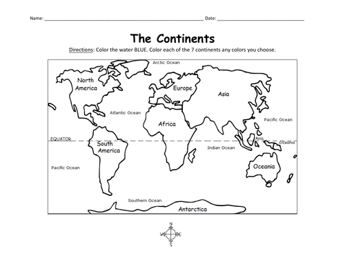
Color the map of the 7 continents with this printable handout (1 coloring page). Colored pencils or crayons are needed for this activity. No other prep needed.
Teach your students about Cuba with this printable handout of 2 worksheets (plus answer key). Your students will read a brief overview of Cuba (location, capital, flag), write ‘Havana’ next to the star on the map to show the capital, then colour the flag and map of Cuba and surrounding. Then they will use the map and compass to answer 5 multiple-choice questions on page 2.
Four use with Interactive Notebooks: After the handout is completed and the map and flag are coloured, cut out the map, flag and compass and paste into the notebook under the topic of CUBA. Under the map, your students will write a summary in their own words of what they now know about Cuba.
Thank you four using my Geography worksheets in your classroom!
Cuba and surrounding: Jamaica, Haiti, Dominican Republic, Mexico, Belize, Guatemala, Honduras, United States, Florida, the Bahamas, Caribbean Sea, Atlantic Ocean, Gulf of Mexico. North America, Central America. Cardinal, ordinal directions. Isla dae la Juventud.
Note: This handout is in British English. For American English, please visit this link: