I'm a teacher and the Author of the Amazon e-book;' Time Smart Teaching' and my mission is to create Geography resources to help teachers save time and reduce their workload. I am sharing additional time saving tips for teachers on my YOUTUBE channel ' Time Smart Teaching' if you fancy dropping by!
I'm a teacher and the Author of the Amazon e-book;' Time Smart Teaching' and my mission is to create Geography resources to help teachers save time and reduce their workload. I am sharing additional time saving tips for teachers on my YOUTUBE channel ' Time Smart Teaching' if you fancy dropping by!
Mercalli scale, Richter scale, Super volcano
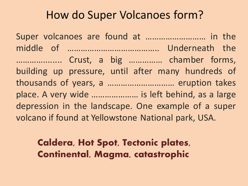
Full lesson with a starter recapping on how super volcanoes form (close passage/ gap fill) then moves on to look at how earthquakes are measured. A practical task on classifying earthqake damage by analysing video footage from youtube is included.
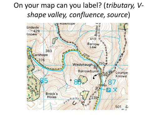
This is a full lesson introducing the water on the land topic. It covers a recap game from KS3, an overview of the course content from exam specification and some activities relating to the long and cross profile of a river. Can be used for other exam boards.
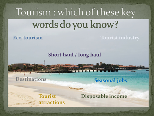
This is a levelled assessment task to review the learning of ks3 students on the topic of Tourism. The existing questions could easily be adapted to suit your scheme of work.
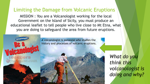
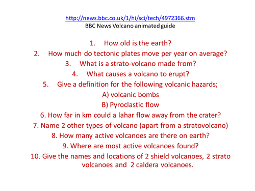
2 lessons on the eruptions of Mt Etna, focusing on the 1992 eruption. Lesson 1 examines the structure of a composite volcano and looks at the impacts of the eruption. Lesson 2 is about diaster planning for volcanic eruptions, specifically for this volcano.
This was done as part of my new Italy topic, and includes differentiated material. Specifically created for yr 8, but easily could be done with year 7. Lesson 2 needs Geog.1 books but it is not essential and could be substituded.
This introduction lesson on our year 7 topic ‘Pole to Pole’ / Cold climates looks at the climate and landscape features of the Tundra biome. Students analyse a climate graph to look at climatic features, and complete a differentiated reading comprehension exercise to pick ou features of the physical geography and landscape of the tundra. The rest of the 6 lesson on this mini scheme of work can be bought separately, or as a bundle for £8 from my tes shop, see resource entitled ’ Tundra Biome Year 7 SOW’
https://www.tes.com/teaching-resource/tundra-biome-year-7-sow-siberia-antarctica-12231148
During the nationwide corona virus lock-down this Spring I created this resource for fellow parents, struggling to home-tutor their kids whilst remotely working. Each of these Geography learning activities are simple, encourage a range of skills and does not require computer access. Most Primary school aged children should be able to complete relatively independently. please share widely.
Pinterest is a great search enguine and social media tool to use when you want to make something visual and create impact. I often find myself browsing creative Geography teaching ideas on here and so I thought I would put them together as a ‘board’ for you to pick and choose which ones might be fun ways to deliver geographical knowlege and understanding, with a fun, artistic twist. Almost all the resources on here are freely available to use, download or recreate with a range of ability and challenge levels for KS3 -KS4. These learning tasks can easily be used for home learning / home schooling, or in the classroom and outdoors. From origami cactus, making portraits with maps and using lego to build a soil profile, there is sure to be something for each class and learner.
Full lesson looking at the different properties of tectonic boundaries. Students extend and finish the mind map example based on the information provided in the powerpoint.
This structured talking exercise can take place between small groups of 2 or more people. Each person rolls 2 die to be directed to co-ordinates on a grid which lead to a question or discussion point. Most questions are intended to be reflective and make connections between geographical understanding at GCSE level ( years 9-11) and the current pandemic lockdown and social distancing measures. This encourages students to form opinions and make wider connections with their geographical knowledge. It is appropriate for a classroom, or distance /home based learning and could be done with a parent or carer.
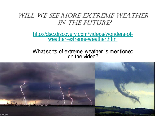
This is a lesson looking at trends in extreme tornadoes and where they occur. Activities include a mapping activity, analyzing data and a group facts race exercise, followed by a journalistic report.
Review slides recapping on how the following features are made:ask asks students to work in groups to produce a poster presentation to deliver to the class on one of the features
A pond is an example of a small-scale ecosystem that we typically student at GCSE Geography. Pond ecosystems depend on balance and equllibrium of all the interdependant parts that make it up; both the living ( biotic) and non-living ( abiotic). This lesson presumes you are lucky enough to have a pond on, or close to your school site to visit and carry out the field sketching tasks. However, if not, there is a detailed picture of a pond ecosystem on the slide they can copy if needed. Students start with a discussions, recap on producers, consumers and decomposers ( this lesson assumes a base-line understanding on food chains). Students sketch the pond with guidance and label appropriately using the mini-beasts spotter card to help them identify animals found on the pond, or through pond-dipping There is an exit card/ small write up task at the end.
This lesson includes simple tasks to work through and was designed for year 7 / 8 Geography at Ks3. The lesson focusses on the Geograhy of the North West England region to build up understanding in preparation for the GCSE Geography focus on the UK. Suitable for distance or remote learning.
Earth day occurs in Spring, on April 22nd each year, however this lesson resource can be used all year round to encourage Primary and KS3 aged students to appreciate and show gratitude to our amazing world. There is a blank 28 day calendared worksheet that students fill in using the gratitude reflections and prompts on the accompanying sheet. It can be used during any month of the year. The tasks are varied between human and physical geography elements and also include active tasks and skills like Yoga, languages, field-sketching and describing landscapes. The daily tasks are in keeping with the earth day theme of ‘observing the need to protect the earth’s environment’.
These calendars could be stuck into pupil workbooks and be used as a reference point for starters and plenaries to lessons. More able students could be challenged to create their own 28 plan for gratitude after completing the one given. The completed gratitude calendars could be photocopied and blown up onto A3 to make stimulating classroom displays for open-evenings or parents evening. etc. A couple of the daily ideas have weblinks attached, which are shown at the bottom of the resource.
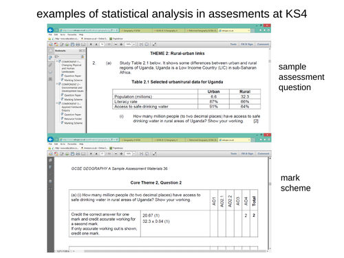
I have picked out 4 separate exam questions from the AQA GCSE Geography specimen papers with the mark scheme attached for mock exam practise. Student must be familiar with statistical analysis and be able to interpret and draw conclusions from unfamiliar data sets. This counts towards the numeracy strands assessed in the new curriculum framework.
This study aid has been produced to help students use subject specific describing words in their examination writing. The Mat gives a visual stimulus to show at a glance a range of vocabulary that students can use when describing places or processes linked to Human Geography topics and landscapes, in relation to paper 2 and 3. These have a range of uses, and could be given out during mock examinations to help the lower ability students. They could be colour printed an stuck into student books or laminated and stuck down onto desks. They would be really useful for teachers to don’t always teach in the same classroom who have portable displays. These learning mats were taken from my other resource ; GCSE Geography Literacy displays’ and made more pupil friendly.
Differentiated resource to allow students to show what they know about the causes effects and solutions to climate change (global warming).\n\nThere is a level assesment criteria and a writing frame to help less able students.\n\nSuitable for years 7 and 8