Fun and visually attractive, this Christmas themed atlas work sheet is great for end of term group activities. All you need is an atlas.
A double sided Christmas themed activity sheet. Activities include: finding capital cities, finding countries, locating oceans, using data sets, drawing flags and using geographic language to describe locations - most with a festive theme. Also: draw a snowman, draw a Christmas tree and name all nine of Santa's reindeer.
Included is a display slide with learning objectives and outcomes, an activity slide with instructions, teacher notes and a lesson plan.
This resource was featured by the TES in their blog last year, and recieved a 5* review.
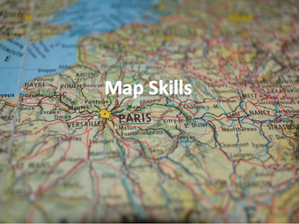
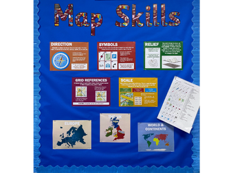
This work booklet guides pupils through vital mapping skills by giving them a ‘how to guide’ as well as a chance to practise their new skills in a variety of questions and tasks. The booklet is aimed at children in upper KS2 and lower KS3 and can be easily adapted to suit. The booklet can be given at the end of a unit of work or spread out across several lessons.
The mapping skills included in this work booklet include:
4 Figure Grid References
6 Figure Grid References
Compass Directions
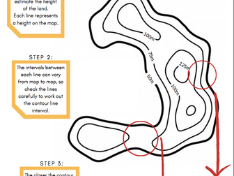
Contour Lines
Calculating Scale
Each topic above includes a one-page ‘how to guide’ and well as a corresponding 'activity sheet.'
Download is in pdf format.
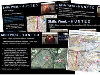
Two lessons around the theme of Channel 4’s Hunted series. Can be used as end of term or skills based activities. All resources are given, including three worksheets, all answers to activities and several embedded video clips. The two lesson PowerPoints are provided as links to files on a cloud as they contain several clips so are too large for TES file size restrictions.
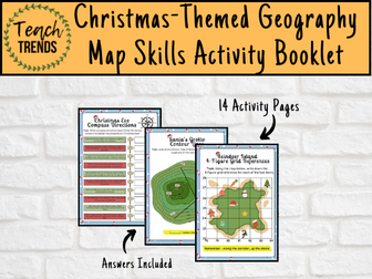
Are you ready to turn this holiday season into a global adventure for your young explorers? Introducing our enchanting Christmas-themed geography map skills activity booklet, specially crafted for curious minds aged 10-14!
Festive Learning Fun: Transform geography lessons into a holiday celebration! Each activity is designed to weave Christmas magic into essential map skills, making learning both educational and joyous.
Engaging and Age-Appropriate: Tailored for 9-12 year olds, our activities strike the perfect balance between challenge and entertainment. Watch as your child hones their map-reading skills while embracing the holiday spirit.
Santa’s Global Adventure: Follow Santa’s journey around the world! From the North Pole to bustling cities and exotic landmarks, each activity unveils a new destination, fostering cultural awareness and geographical knowledge.
Map Skills Included:
Grid References
Scale & Distance
Compass Directions
Contour Lines
Time Zones
A total of 14 activity pages with answers included.
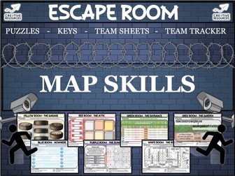
Geography Map Skills Team Building Escape Room - Virtual Escape Room run through PowerPoint by Cre8tive Resources! This lasts an hour or under depending on how quick the teams can solve each puzzle! Students love this style of lesson, great as an educational treat for your middle school or even high school class. Will your students be able to escape before time runs out?
The escape room puzzles content will be tailored to the topic of this escape room.
Escape Room Product Contents:
☞ Escape Room Interactive Tracker PowerPoint - Keeps the competitive nature on display
☞ Escape Room Puzzle Keys (Six Sets for Six Teams)
☞ Escape Room Team sheet - Record codes, answers clues as they progress through the 7 rooms
☞ Escape Room Puzzles (7 Rooms = 7 Different styles of Puzzles involving numeracy, literacy and lateral thinking)
☞ Bonus Riddles with every puzzle.
☞ Teacher Answer Sheet - Quickly confirm to teams they have solved the puzzle correctly
☞ Teacher instructions of how to set up the escape room and what to print and top tips and shortcuts.
☞ Successful Escape Certificates for those that complete the entire challenge (There is a difficult bonus escape too :) for any quick teams
✿ The 7 Rooms include: The Garage, The Attic, The Nowhere, The Dungeon, The Entrance, The Rest Room and the Garden. (Each Puzzle has been adapted to suit the topic of this Escape Room (this one is very general and fun!) and is suitable for Middle School and High School students.
Our Philosophy
✿ We aim to help you equip students with the knowledge and skills to take ownership of their own learning.
✰✰✰✰✰✰✰✰✰✰✰✰✰✰✰✰✰✰✰✰✰✰✰✰✰✰✰✰✰✰✰✰✰✰✰✰✰✰✰✰✰✰✰✰
Why not try out one of our other fantastic best selling Escape Rooms
⇨ English and Language Digital Escape Room
⇨ Dr. Jekyll and Mr. Hyde Digital Escape Room
⇨ Big Fun End of Term Digital Escape Room
⇨ PSHE and Form Time Escape Room
⇨ Careers Digital Escape Room
⇨ Drama and Performance Digital Escape Room
JUST PRINT AND GO!
They can also be used to encourage a flipped learning environment.
Any question please do feel free to get in contact:
teachercentralltd@gmail.com
Best FREE Resources (The Geography Shop)
https://www.tes.com/teaching-resource/-12899088 (Climate Change SoW)
https://www.tes.com/teaching-resource/-12899440 (Development SoW)
https://www.tes.com/teaching-resource/-12638984 (Waste SoW)
https://www.tes.com/teaching-resource/-12451443 (Britain Globalisation SoW)
https://www.tes.com/teaching-resource/-12741793 (Local Area Investigation SoW)
https://www.tes.com/teaching-resources/bundler/12949461 (Cambridge International)
https://www.tes.com/teaching-resource/-12922653 (Israel & Palestine)
https://www.tes.com/teaching-resource/resource-12485457 (What is Geography?)
I hope you find this SoW useful. If you have, I have created a series of resources.
8 separate lessons based on Mexico. SMART files and tasks are included for each lesson.
Geography Skills Lessons including:
-Locating specific areas on an atlas
-Longitude and Latitude
-Comparing Climate Zones
-Biomes of Mexico
-Comparing Population Pyramids
-Dual Bar Charts
-Analysing rainfall and temperature
-Climate and rainfall
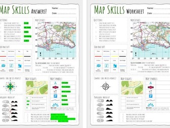
Up to date worksheet for map skills for any Geography curriculum and Key Stage.
Includes:
4fig grid references
6fig grid references
direction
compass
scale
map symbols
and more
Use this document to support the slimmed down national curriculum. Key subject specific skills, for example geographical inquiry, map reading and creating and field work,mapped out for each year group for Years 1 to 6.
Also available in editable word format email webb.gaz@gmail.com
website: gwsupport.co.uk
Full unit of work for map skills. All lesson are suitable for 50 minutes to 1 hour of teaching time. Includes supporting worksheets for lessons - no additional resources are required. Develops core skills for geography students in KS3 or high ability KS2.
All lessons have a starter and lesson objectives. All PowerPoints in the same signature style.
Lesson sequence:
1 - Introduction to maps
2 - Where is the UK?
3 - Compass points
4 - Map symbols
5 - 4 and 6 figure grid references
6 - Scale and distance
7 - Atlas skills
8 - Height and relief
9 - Longitude and latitude
10 - Design your own treasure map
11 - Mapzone GIS
Also includes Types of Geography lesson (can be used as an introduction lesson for Y7), Geography Literacy mat and Geography Numeracy/Map Skills mat.
Homeworks - 3 x countries and capitals test sheets to develop global place knowledge
For more resources visit This is Geography. Full SoW for all new GCSE specifications - AQA, Edexcel, OCR, CIE IGCSE, Edexcel IGCSE and Eduqas. As well as over 200 lessons for KS3 and KS2. Want something bespoke designing? Email us for further details info@thisisgeography.co.uk
This is a 10 lesson (End of Unit test) SOW to introduce Geography as a new subject and to develop map skills. There are lessons on;
Introduction / types of geography
continents and oceans
Europe
Physical Geog of Europe
The British Isles
Map symbols
four and six figure grid references
Height on a Map
Scale.
Also included with PP is a 35+ page workbook to match.
I hope you enjoy :)
A map skills homework booklet for use with KS3 Geography classes.
An amalgamation of worksheets I have gathered over the years to create a comprehensive and easy to mark Map Skills Homework Booklet!
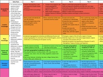
Progression of skills from years 1 to 6.
Skeletal planning ideas for case studies.
Ideal for geography leaders/co-ordinators.
Add your school name and logo.
EYFS – Local Area
Year 1 – Weather – Seasons and the Local Area
Year 2 – Hot and Cold Areas – Equator and the Poles
Year 3 – Mountains, Settlements and Land Use
Year 4 – Volcanoes and Earthquakes, Settlements and Land Use
Year 5 – Climate Zones and Biomes, Food and Trade Links
Year 6 – Rivers and the Water Cycle, and Natural Resources
Contains public sector information licensed under the Open Government Licence v3.0.
A big lesson with lots of opportunity for differentiation and engagement, as well as paired or group work.
Basically, students learn how to describe places, and then apply this skill. It would work well as a skills building lesson in KS3, or as an end of term type lesson with either KS3 or KS4.
There are differentiated resources for lower and higher, and a number of ways in which the activities could be undertaken (which are in the lesson plan). There are teacher notes and a lesson plan. The activities are clear, and there are Superstar extension activities.
---
The main aim is…
This is a big lesson which could be used as an end of term activity, or as a skills building lesson.
Students either learn or develop their geographical terminology and then apply / demonstrate using photos of actual places.
Key ideas and content…
We can describe places using geographical language.
It is more effective to use the correct key terms and descriptive language.
To differentiate…
Pass the sheets round on a timer, with the challenge of either adding more key terms or improving existing ones.
Stick the sheets on the wall around the room, give each student a different key term to look for. Students go round the room.
Insist on certain terms being applied.
To extend…
Insist on a description of features which aren’t necessarily visible.
Students find their own photos and analyse them.
Peer assessment.
There are some tricky terms in the key terms activity, use to stretch students.
To assess…
Discussion points.
The work produced.
Peer assessment opportunity.
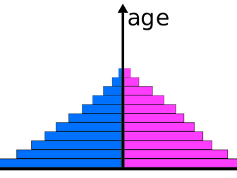
A KS3/ KS4 Geography lesson to improve skills with a focus on population pyramids. Students draw their own population pyramid using UK data. They then describe and explain the patterns in the population pyramid. The final task requires them to compare population pyramids from 4 different countries. Differentiated with extra support for the less able and challenge tasks for the more able. Fully resourced.
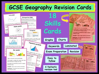
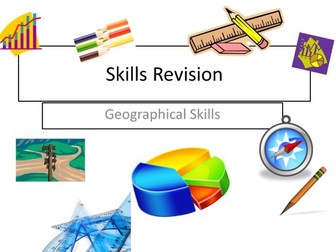
A whole set of lessons to cover all geographical skills. Differentiated and challenge activities throughout. Excellent for teaching first time, recapping or revision.
Designed around OCR A specification, however all skills included are fundamental parts of geography regardless of the specification.
This will save you a lot of time and planning!!