
33Uploads
20k+Views
2k+Downloads
Citizenship

Maps of UK and Europe with flags and labels to connect
Line maps of the UK and Europe together with the country names and flags to connect.
Students can either label with lines or cut and stick labels into the correct nations.
Print/ photocopy onto A3 for a larger map.
Maps with labels, Continents, Oceans, European Union and UK
Three maps with labels for students to attach.
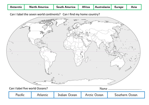
Map 1 - World map with continents and ocean labels to link.
Atlantic, Arctic Pacific, Indian, Southern
Antarctic, North America, South America, Africa, Australasia, Europe, Asia
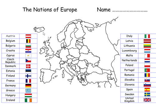
Map 2 - European map with all EU countries and their flags to link.
Austria, Belgium, Bulgaria, Croatia, Republic of Cyprus, Czech Republic, Denmark, Estonia, Finland, France, Germany, Greece, Hungary, Ireland, Italy, Latvia, Lithuania, Luxembourg, Malta, Netherlands, Poland, Portugal, Romania, Slovakia, Slovenia, Spain, Sweden and the UK.
Map 3 - United Kingdom map with four nations, flags and names to link.
Scotland, England, Wales and Northern Ireland.

Labelling the Body - Boy and Girl - Science
Activity sheet with a drawn body in the centre.
Labels for the upper, lower body and face provided. Students can cut and stick or link up with lines.
Great to photocopy onto A3 to increase the image size.
Individual, paired or group activity!
Label the World continents and oceans - Geography and Understanding the world
Activity sheet with a large world map in the centre.
Labels for the continents and oceans at the top and bottom, students can cut and stick or link up with lines. They're then asked to find their home country and label it to understand where it is in the world.
Great to photocopy onto A3 to increase the map size.