Hi, A few years ago someone asked, ‘Is your work life stressful’? I was extremely stressed! Never enough time for myself/family. I was completely overloaded, overwhelmed & had no work life balance. I realised the most important thing I needed was time. So, after 20 years I am taking some time out. My intention is to create high quality resources, to help teachers take control of their workload, help reduce stress & enable their children to Love Learning Geography.
Hi, A few years ago someone asked, ‘Is your work life stressful’? I was extremely stressed! Never enough time for myself/family. I was completely overloaded, overwhelmed & had no work life balance. I realised the most important thing I needed was time. So, after 20 years I am taking some time out. My intention is to create high quality resources, to help teachers take control of their workload, help reduce stress & enable their children to Love Learning Geography.
Powerpoint 4 point compass directions , world map, Equator - Interactive & animated ks1 ks2
If you are looking for vibrant, interesting and fun activities…….take a look at my resources.
This resource will help your students learn compass directions. The power point is interactive. It can be used for ks1 ks2 ks3.
The compass - Includes an animated vibrant power point, lesson plan and the compass work sheet. The power point can be used on a whiteboard or with a projector. It has animations and moving objects. The worksheet is in colour / black and white.
Have a look at my other resources.
Hope your class loves learning with my resources :)
**OCR flooding ks3 ks4 River management techniques flood defences dealing with flooding **
A collection of resources to help students understand river management information (paper 1). Easy to follow if non-specialist. Specific to the OCR ks4 spec.
Contains an interactive power point, a quiz and worksheet. This resource will help your students learn the different types of soft and hard defences. Suitable for ks3 ks4. The resources can be used on its OWN or with the other resources. The power point is vibrant and interactive. The power point can be used on a white board or with a projector. They have animations and moving objects. The power points are easy to use and explain. Sources are on the power point.
REMOVE THE WATERMARK AND THE FILES ARE THE SAME AS THE COVER PICTURE
If you are looking for vibrant, interesting and fun activities…….take a look at my other resources. I have created power points on OCR background to rivers, geomorphological processes, river landforms, river management and the river case study.
I will be adding lots of new resources. Follow me and thank you if you have time to give me feedback.
Hope your class loves learning with my resources :)
Crosswords ecosystems & Tropical rainforests case study Epping Forest & the Amazon GCSE geography lesson or revision ks3 ks4
You can use the crosswords in a number of ways:
Print the sheet A3 for a group activity. First team to complete all of the information wins.
If you are running out of time to complete the topic- give the student their own A4 sheet and ask them to complete as many as they can before the end of the lesson.
Use the crossword at the start or the end of the topic.
Use the AQA GCSE 9-1 Geography book Widdowson et al (2016) First edition to complete the crossword.
• Epping forest- deciduous forest case study p60-1
• Tropical rainforest-causes & effects case study p72-5
Answers included on the back of the sheets.
REMOVE THE WATERMARK AND THE FILES ARE THE SAME AS THE COVER PICTURE
Take a look at my other resources :) I will be adding lots of resources this year. Please follow me and thank you if you have time to give me feedback.
Hope your students love learning with the resources :)
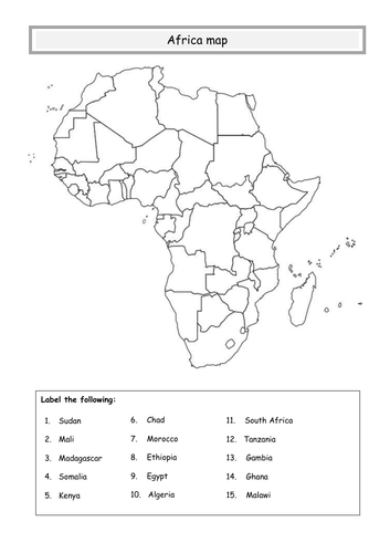
Hello,
My aim to help teachers reduce their workload and encourage students to love learning geography. I used to spend hours looking for blank editable maps. So, I thought I would make a bank for free blank maps. I have 50 free blanks maps available in my shop.
If you have the time to show your appreciation and click 5 stars it is very helpful for me to see what resources people need.
Good luck
:)
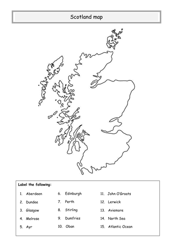
GB, UK & BI vibrant power point for ks1 ks2 ks3.
If you are looking for vibrant, interesting and fun activities…….take a look at my resources.
This resource will help your students learn the difference between Great Britain, the United Kingdom and the British Isles. The power point is interactive. It can be used for ks1 ks2 ks3.
GB, UK & BI - Includes an animated vibrant power point, lesson plan and student work sheet. The power point can be used on a white board or with a projector. It has animations and moving objects. The worksheet is in black and white and has space for you to adapt your lesson. The plenary is a great kinesthethic activity and get students thinking and moving.
REMOVE THE WATERMARK AND THE FILES ARE THE SAME AS THE COVER PICTURE
Have a look at my other resources.
Hope your class loves learning with my resources :)
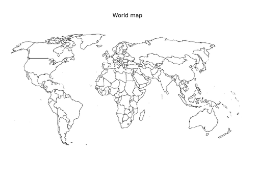
Hello,
My aim to help teachers reduce their workload and encourage students to love learning geography. I used to spend hours looking for blank editable maps. So, I thought I would make a bank for free blank maps. I have 50 free blanks maps available in my shop.
If you have the time to show your appreciation and click 5 stars it is very helpful for me to see what resources people need.
Good luck
:)