I've worked in primary teaching for over 10 years and specialise in creating fun and engaging educational resources, particularly for Geography and History.
I've worked in primary teaching for over 10 years and specialise in creating fun and engaging educational resources, particularly for Geography and History.
This lesson is part of a wider Geography unit called Great Missenden – A Village Settlement which is designed for students in upper KS2 (Y4-6).
The presentation introduces students to the concept of settlements and asks them to categorise them by size (e.g. hamlet, village, town, city, conurbation). It then introduces them to a range of human geographical features found in settlements (e.g. post offices, sports stadiums).
In the activity students identify a variety of human geographical features found in settlements. It is differentiated two ways:
Easier – Students identify the features of settlements with normal clues.
Harder – Students identify the features of settlements with jumbled up clues.
Extension – Students identify which types of settlements these features are usually found in.
If you like this resource, we would appreciate a review! We will happily send you a free resource in return for a review or useful suggestions/feedback. Contact us at ed@teachitforward.co.uk.
This lesson is part of Exploring the United Kingdom, a Geography unit designed for KS1 and lower KS2 (Y2-4).
First the presentation introduces children to the flags of the United Kingdom and their names.
Students then complete one of two differentiated activity worksheets:
Easier – Students complete cloze procedure sentences about UK flags (with clues)
Harder – Students complete cloze procedure sentences about UK flags (no clues)
Extension – Students colour in the three UK national flags which together make up the Union Jack.
If you like this resource, we would appreciate a review! We will happily send you a free resource in return for a review or useful suggestions/feedback. Contact us at ed@teachitforward.co.uk.
This lesson is part of The Seaside, a Geography unit designed for students in KS1 and lower KS2, but can also be taught as a stand alone lesson.
The presentation first explains the difference between human and physical geographical features. It then challenges students to identify a range of seaside features (e.g. cliffs, lighthouse, river mouth) and classify them as human or physical.
In the activity, students identify a range of seaside features and classify them as human or physical.
Easier - Students classify seaside features as human or physical.
Medium - Students label seaside features (with initial letter clues) and classify them as human or physical.
Harder - Students label seaside features (no clues) and classify them as human or physical.
Extension - Students unscramble sentences about the seaside.
If you like this resource, we would appreciate a review! We will happily send you a free resource in return for a review or useful suggestions/feedback. Contact us at ed@teachitforward.co.uk.
This lesson is part of Exploring Brazil, a Geography unit designed for students in KS2 (Y4-6), but can also be taught as a stand alone lesson.
The presentation introduces students to Brazil’s six main biomes including the tropical rainforest, caatinga (desert), Pantanal wetlands, cerrado (savannah) and Atlantic Forest. Students then read an information text to find out more.
In the activity, students write an information text about Brazil’s ecosystems. This can either be done as a short activity or as an extended write in Literacy. (N.B. The activity sheets need to be enlarged to A3 size to provide adequate space for writing.)
Short Activity:
Easier – Students match statements to each ecosystem and write them in each box.
Medium – Students add titles, then match statements to each ecosystem and write them in each box.
Harder – Students add titles and write their own sentences about each ecosystem in the box.
Extension – Students label the different ecosystems on the map, including drawings of animals found in each one.
Extended Writing Activity:
Easier – Students write an information text about Brazil’s ecosystems, including an introductory paragraph.
Harder – Students write an information text about Brazil’s ecosystems, including sub-headings and an introductory paragraph.
If you like this resource, we would appreciate a review! We will happily send you a free resource in return for a review or useful suggestions/feedback. Contact us at ed@teachitforward.co.uk.
Volcanoes is an exciting Geography unit designed for students in KS2.
The planning overview, topic title page and vocabulary page can be downloaded for free here. Lessons include:
L1 – Understanding the structure of the Earth
L2 – Investigating the structure of a volcano (FREE)
L3 – Locating the world’s famous volcanoes
L4 – Investigating the five deadly features of a volcanic eruption
L5 – Understanding tectonic plates
L6 – Exploring the effects of volcanic eruptions on Montserrat
L7 – Why do people live near volcanoes?
Each lesson includes a presentation and differentiated activities/worksheets.
A FREE newspaper report template is also included in this unit.
If you like this resource, we would appreciate a review! We will happily send you a free resource in return for a review or useful suggestions/feedback. Contact us at ed@teachitforward.co.uk.
This lesson is part of Exploring Brazil, a Geography unit designed for students in KS2 (Y4-6), but can also be taught as a stand alone lesson.
The presentation first locates Brazil in the world’s climate zones and asks children to infer what the country’s weather and climate might be like.
Next, students look at three areas of Brazil in more detail – Manaus in the Amazon, Teresina in the caatinga desert region and Porto Alegre in the south of the country – and investigate a climate graph.
There are two activities:
Activity 1:
Students first investigate three climate graphs, looking at temperature and rainfall. Their challenge is to match each graph to an area of Brazil, explaining their reasoning for their choices. It is differentiated 2 ways:
Easier – Students match two statements to each climate graph, then match each graph to one of the three cities/regions.
Harder – Students write sentence describing the temperature and rainfall patterns in each climate graph, then match each graph to one of the three cities/regions.
Activity 2:
Students create their own Brazil climate graphs in Microsoft Excel using step-by-step instructions.
If you like this resource, we would appreciate a review! We will happily send you a free resource in return for a review or useful suggestions/feedback. Contact us at ed@teachitforward.co.uk.
This lesson is part of Exploring Spain, a Geography unit designed for upper KS2 students (Y4-6), but can also be taught as a stand alone lesson.
Students first learn about the Iberian peninsula. They then explore some of the main geographical features of Spain itself and categorise these into human (e.g. cities) and physical (e.g. mountains).
The activity challenges students to identify these features on a map of Spain. It is differentiated two ways:
Easier – Students identify human & physical features of Spain using a colour-coded map and word bank
Harder – Students identify human & physical features of Spain using a map & word bank
Extension – Students complete a cloze procedure text about the human and physical geography of Spain.
If you like this resource, we would appreciate a review! We will happily send you a free resource in return for a review or useful suggestions/feedback. Contact us at ed@teachitforward.co.uk.
This lesson is part of Exploring Spain, a Geography unit designed for upper KS2 students (Y4-6), but can also be taught as a stand alone lesson.
In the presentation students embark on a tour of Madrid, learning interesting facts about Spain’s capital city along the way. They visit sites including the famous Royal Palace, the Sun Gate and the Santiago Bernabeú Stadium, home of Real Madrid.
The lesson has two activities:
Quiz activity:
Students use an online encyclopedia to answer questions about Madrid.
Guided tour writing activity:
Students give their very own guided tour of Madrid.
Easier – Students write a guided tour of Madrid using a writing frame.
Harder – Students write a guided tour of Madrid by sticking images into their exercise books.
If you like this resource, we would appreciate a review! We will happily send you a free resource in return for a review or useful suggestions/feedback. Contact us at ed@teachitforward.co.uk.
This lesson is designed for KS2 children. It can be taught as a stand alone lesson but is also available as part of two wider units, both of which are available on TES:
-Earthquakes
-Volcanoes & Earthquakes
N.B. Ideally children have a grounding in latitude and longitude prior to this lesson. The unit Understanding Latitude & Longitude is an ideal introduction to the topic.
First the presentation introduces students to latitude and longitude and goes through how to find the coordinates of a point step-by-step. It then asks them to find the latitude and longitude of several world capital cities.
The activity challenges students to locate the world’s biggest earthquakes using their latitude and longitude. It is differentiated three ways:
Easier – Students locate 12 earthquakes using latitude and longitude.
Medium – Students locate 15 earthquakes using latitude and longitude.
Harder – Students locate 18 earthquakes using latitude and longitude.
If you like this resource, we would appreciate a review! We will happily send you a free resource in return for a review or useful suggestions/feedback. Contact us at ed@teachitforward.co.uk.
This lesson is part of Investigating Rivers, a unit designed for upper KS2 (Y4-6).
First the presentation looks at sources of water and highlights the importance of this critical resource. It then introduces the main processes of the water cycle including key concepts such as evaporation, condensation and precipitation.
The activity then challenges students to label a diagram of the water cycle. It is differentiated three ways:
Easier – Students have all the label clues.
Medium – Students have only four label clues.
Harder – Students have no label clues.
Extension – Students complete a cloze procedure paragraph about the water cycle.
If you like this resource, we would appreciate a review! We will happily send you a free resource in return for a review or useful suggestions/feedback. Contact us at ed@teachitforward.co.uk.
Our World is a comprehensive Geography topic about Planet Earth, suitable for KS1 and lower KS2 (Y1-3).
The planning overview, topic title page and vocabulary page can be downloaded for free here. Lessons include:
L1 – Completing a world map jigsaw
L2 – Identifying the continents and oceans of the world (FREE)
L3 – Where do we live?
L4 – Identifying human and natural features of the world
L5 – Investigating satellite photos of famous world landmarks
L6 – Introduction to compass directions
L7 – Identifying world climate zones
L8 – Identifying the countries and capitals of the UK (FREE)
Each lesson includes a presentation and differentiated activities/worksheets.
If you like this resource, we would appreciate a review! We will happily send you a free resource in return for a review or useful suggestions/feedback. Contact us at ed@teachitforward.co.uk.
This lesson is part of Understanding Latitude and Longitude, a unit designed for students in upper KS2 and KS3. It can also be taught as a stand-alone lesson.
This lesson explains step-by-step how to find the coordinates of a point on a world map using lines of latitude and longitude.
In the activity, students are challenged to find the latitude and longitude of 12 points in all four quadrants of a world map. It is differentiated three ways:
Easier – Students find coordinates of 12 points in the NE, SE, SW and NW quadrants of the world map respectively. The compass directions are already filled in.
Medium – Students find coordinates of 12 points in the NE, SE, SW and NW quadrants of the world map respectively.
Harder – Students find coordinates of 12 points randomly distributed across the four quadrants of the world map.
Extension – Students are challenged to draw and label 4 more points on to their map.
If you like this resource, we would appreciate a review! We will happily send you a free resource in return for a review or useful suggestions/feedback. Contact us at ed@teachitforward.co.uk.
This lesson is part of Exploring the United Kingdom, a Geography unit designed for KS1 and lower KS2 (Y2-4).
In the lesson, students learn about the four seasons and characteristics associated with each. First they have to guess each season using different clues. They then find out about the different types of weather associated with each season.
The colourful activity is differentiated three ways:
Easier – Students match 16 pictures (with labels) to the seasons.
Medium – Students match 20 pictures (with labels) to the seasons.
Harder – Students match 20 pictures to the seasons and label them.
If you like this resource, we would appreciate a review! We will happily send you a free resource in return for a review or useful suggestions/feedback. Contact us at ed@teachitforward.co.uk.
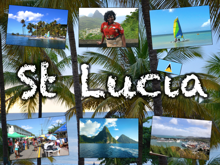
Exploring St Lucia is a Geography unit designed for students in KS2.
As a tropical island in the Caribbean, St Lucia is great for teaching about a contrasting non-European country.
The planning overview, topic title page and vocabulary page can be downloaded for free here. Lessons include:
L1 – Locating St Lucia in the Caribbean
L2 – Identifying the human and physical features of St Lucia
L3 – Investigating satellite photos of St Lucia
L4 – Using compass directions to locate places in St Lucia
L5 – Comparing the weather of St Lucia and the UK
L6 – Comparing St Lucia with the UK
Each lesson includes a presentation and differentiated activities/worksheets.
If you like this resource, we would appreciate a review! We will happily send you a free resource in return for a review or useful suggestions/feedback. Contact us at ed@teachitforward.co.uk.
This fun jigsaw activity is a great geography resource for reinforcing children’s knowledge of the world.
It is also available as part of the Our World topic, an introduction to the geography of Planet Earth for KS1 and lower KS2
The presentation introduces students to a map of the world and highlights physical features including the continents, oceans, rivers and mountain ranges.
The jigsaw puzzle activity is differentiated six ways. The age brackets below are a rough guide:
6 pieces – EYFS
12 pieces – EYFS/Y1
24 pieces – Y1/2/3
36 pieces – Y2/3/4
48 pieces – Y3/4/5
60 pieces – Y4/5/6
A guide map is included for students in Early Years and KS1. Challenge more able KS2 students to complete the puzzle without the guide map.
If you like this resource, we would appreciate a review! We will happily send you a free resource in return for a review or useful suggestions/feedback. Contact us at ed@teachitforward.co.uk.
This lesson is part of Exploring the United Kingdom, a Geography unit designed for KS1 and lower KS2 (Y2-4).
The presentation first explains how every country – just like people – has its own special features and characteristics. It then introduces a variety of famous UK landmarks, sports and foods and challenges students to work out whether each is from England, Scotland, Wales or Northern Ireland.
The activity can be done in two ways:
Partner activity:
In mixed ability partners, students match 20 features and characteristics to the four UK countries.
Individual activity:
Students match 20 features/characteristics to the four UK countries.
Easier – Students match features/characteristics to each country (using stickers with labels).
Harder – Students match features/characteristics to each country and label each one (using stickers without labels).
If you like this resource, we would appreciate a review! We will happily send you a free resource in return for a review or useful suggestions/feedback. Contact us at ed@teachitforward.co.uk.
This lesson is part of Mountain Environments, a Geography unit designed for students in upper KS2 (Y4-6).
First the presentation looks at features of a mountain climate including lower temperatures and increased rainfall. It then focuses in more detail on the climate of Mount Everest.
There are two activities:
Interpreting climate graphs
In this activity students look at and answer questions about temperature graphs for both the summit and base camp of Mount Everest. It is differentiated two ways:
Easier – Students answer questions about temperature graphs for Mount Everest (suitable for Year 4 and 5).
Harder – Students answer questions about temperature graphs for Mount Everest (suitable for Year 6).
Creating a climate graph in Excel
In this ICT activity, students create their own climate graph, including temperature and rainfall, for the summit of Mount Everest using Microsoft Excel.
If you like this resource, we would appreciate a review! We will happily send you a free resource in return for a review or useful suggestions/feedback. Contact us at ed@teachitforward.co.uk.
This lesson is part of Understanding Trade, a Geography unit designed for students in upper KS2 (Y5-6).
First the presentation helps students understand what trade is and introduces the concepts of imports and exports. It does this by linking these ideas to every day products we buy. It also looks at the different scales of trade – local, national and international.
The activity then challenges students to match up products with statements about the company which makes them and where they are produced/manufactured.
Easier – Match the products to the statements (on stickers)
Harder – Match the products to the statements (written)
Extension – Students complete a cloze procedure paragraph about trade.
If you like this resource, we would appreciate a review! We will happily send you a free resource in return for a review or useful suggestions/feedback. Contact us at ed@teachitforward.co.uk.
This lesson is designed for KS2 children. It can be taught as a stand alone lesson but is also available as part of two wider units, both of which are available on TES:
-Earthquakes
-Volcanoes & Earthquakes
The presentation investigates the five deadly features of earthquakes including ground shaking, tsunamis, landslides, raising/lowering of land and liquefaction.
It is followed up by an activity which is differentiated four ways:
Easier – Students match pictures of the five features of an earthquake to descriptions.
Medium – Students complete cloze procedure sentences. They then match pictures to each description.
Harder – Students complete cloze procedure sentences. They then match pictures to each description and add a title for each section.
Hardest – Students stick pictures of the five features of an earthquake in their books and write their own description next to each one.
Extension – Can students unscramble the jumbled up earthquake facts?
If you like this resource, we would appreciate a review! We will happily send you a free resource in return for a review or useful suggestions/feedback. Contact us at ed@teachitforward.co.uk.
This lesson is part of Understanding Trade, a Geography unit designed for students in upper KS2 (Y5-6).
The presentation introduces the concept of highest value exports. It then draws a link between a country’s highest value export and its human and physical resources (e.g. transport links, oil reserves). Four example countries and their highest value export are then looked at in more detail.
In the activity, students are challenged to identify the highest value exports and GDP/capita of countries around the world using Google Maps/atlases and an online map. The activity is differentiated three ways:
Easier – Students identify highest value exports of 25 countries
Medium – Students identify highest value exports and GDP/capita of 25 countries
Harder – Students identify highest value exports and GDP/capita of 30 countries
If you like this resource, we would appreciate a review! We will happily send you a free resource in return for a review or useful suggestions/feedback. Contact us at ed@teachitforward.co.uk.