I've worked in primary teaching for over 10 years and specialise in creating fun and engaging educational resources, particularly for Geography and History.
I've worked in primary teaching for over 10 years and specialise in creating fun and engaging educational resources, particularly for Geography and History.
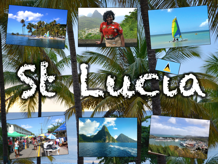
Exploring St Lucia is a Geography unit designed for students in KS2.
As a tropical island in the Caribbean, St Lucia is great for teaching about a contrasting non-European country.
The planning overview, topic title page and vocabulary page can be downloaded for free here. Lessons include:
L1 – Locating St Lucia in the Caribbean
L2 – Identifying the human and physical features of St Lucia
L3 – Investigating satellite photos of St Lucia
L4 – Using compass directions to locate places in St Lucia
L5 – Comparing the weather of St Lucia and the UK
L6 – Comparing St Lucia with the UK
Each lesson includes a presentation and differentiated activities/worksheets.
If you like this resource, we would appreciate a review! We will happily send you a free resource in return for a review or useful suggestions/feedback. Contact us at ed@teachitforward.co.uk.
This fun jigsaw activity is a great geography resource for reinforcing children’s knowledge of the world.
It is also available as part of the Our World topic, an introduction to the geography of Planet Earth for KS1 and lower KS2
The presentation introduces students to a map of the world and highlights physical features including the continents, oceans, rivers and mountain ranges.
The jigsaw puzzle activity is differentiated six ways. The age brackets below are a rough guide:
6 pieces – EYFS
12 pieces – EYFS/Y1
24 pieces – Y1/2/3
36 pieces – Y2/3/4
48 pieces – Y3/4/5
60 pieces – Y4/5/6
A guide map is included for students in Early Years and KS1. Challenge more able KS2 students to complete the puzzle without the guide map.
If you like this resource, we would appreciate a review! We will happily send you a free resource in return for a review or useful suggestions/feedback. Contact us at ed@teachitforward.co.uk.
This lesson is part of Exploring the United Kingdom, a Geography unit designed for KS1 and lower KS2 (Y2-4).
The presentation first explains how every country – just like people – has its own special features and characteristics. It then introduces a variety of famous UK landmarks, sports and foods and challenges students to work out whether each is from England, Scotland, Wales or Northern Ireland.
The activity can be done in two ways:
Partner activity:
In mixed ability partners, students match 20 features and characteristics to the four UK countries.
Individual activity:
Students match 20 features/characteristics to the four UK countries.
Easier – Students match features/characteristics to each country (using stickers with labels).
Harder – Students match features/characteristics to each country and label each one (using stickers without labels).
If you like this resource, we would appreciate a review! We will happily send you a free resource in return for a review or useful suggestions/feedback. Contact us at ed@teachitforward.co.uk.
This lesson is part of Mountain Environments, a Geography unit designed for students in upper KS2 (Y4-6).
First the presentation looks at features of a mountain climate including lower temperatures and increased rainfall. It then focuses in more detail on the climate of Mount Everest.
There are two activities:
Interpreting climate graphs
In this activity students look at and answer questions about temperature graphs for both the summit and base camp of Mount Everest. It is differentiated two ways:
Easier – Students answer questions about temperature graphs for Mount Everest (suitable for Year 4 and 5).
Harder – Students answer questions about temperature graphs for Mount Everest (suitable for Year 6).
Creating a climate graph in Excel
In this ICT activity, students create their own climate graph, including temperature and rainfall, for the summit of Mount Everest using Microsoft Excel.
If you like this resource, we would appreciate a review! We will happily send you a free resource in return for a review or useful suggestions/feedback. Contact us at ed@teachitforward.co.uk.
This lesson is part of Understanding Trade, a Geography unit designed for students in upper KS2 (Y5-6).
First the presentation helps students understand what trade is and introduces the concepts of imports and exports. It does this by linking these ideas to every day products we buy. It also looks at the different scales of trade – local, national and international.
The activity then challenges students to match up products with statements about the company which makes them and where they are produced/manufactured.
Easier – Match the products to the statements (on stickers)
Harder – Match the products to the statements (written)
Extension – Students complete a cloze procedure paragraph about trade.
If you like this resource, we would appreciate a review! We will happily send you a free resource in return for a review or useful suggestions/feedback. Contact us at ed@teachitforward.co.uk.
This lesson is designed for KS2 children. It can be taught as a stand alone lesson but is also available as part of two wider units, both of which are available on TES:
-Earthquakes
-Volcanoes & Earthquakes
The presentation investigates the five deadly features of earthquakes including ground shaking, tsunamis, landslides, raising/lowering of land and liquefaction.
It is followed up by an activity which is differentiated four ways:
Easier – Students match pictures of the five features of an earthquake to descriptions.
Medium – Students complete cloze procedure sentences. They then match pictures to each description.
Harder – Students complete cloze procedure sentences. They then match pictures to each description and add a title for each section.
Hardest – Students stick pictures of the five features of an earthquake in their books and write their own description next to each one.
Extension – Can students unscramble the jumbled up earthquake facts?
If you like this resource, we would appreciate a review! We will happily send you a free resource in return for a review or useful suggestions/feedback. Contact us at ed@teachitforward.co.uk.
This lesson is part of Understanding Trade, a Geography unit designed for students in upper KS2 (Y5-6).
The presentation introduces the concept of highest value exports. It then draws a link between a country’s highest value export and its human and physical resources (e.g. transport links, oil reserves). Four example countries and their highest value export are then looked at in more detail.
In the activity, students are challenged to identify the highest value exports and GDP/capita of countries around the world using Google Maps/atlases and an online map. The activity is differentiated three ways:
Easier – Students identify highest value exports of 25 countries
Medium – Students identify highest value exports and GDP/capita of 25 countries
Harder – Students identify highest value exports and GDP/capita of 30 countries
If you like this resource, we would appreciate a review! We will happily send you a free resource in return for a review or useful suggestions/feedback. Contact us at ed@teachitforward.co.uk.
London Zoo is a cross-curricula unit suitable for KS1 and lower KS2 (Y2-4).
It is a fun way to learn about one of the world’s most famous zoos.
The planning overview and topic title page can be downloaded for free here. Lessons include:
L1 – Writing a fact file about London Zoo
L2 – Taking a tour of London Zoo
L3 – Using compass directions at London Zoo
L4 – Using grid references at London Zoo
L5 – Matching animals to their habitat
L6 – The history of London Zoo
Each lesson includes a presentation and differentiated activities/worksheets.
If you like this resource, we would appreciate a review! We will happily send you a free resource in return for a review or useful suggestions/feedback. Contact us at ed@teachitforward.co.uk.
This lesson is part of a wider unit called Exploring St Lucia and is designed to teach KS2 students about a contrasting non-European country.
It first introduces St Lucia and the wider Caribbean area, helping students to locate the island within the wider world.
The activity then challenges students to identify St Lucia and other islands in the Caribbean. It is differentiated three ways:
Easier – Students identify 8 countries (with first-letter clues).
Medium – Students identify 10 countries and 3 seas/oceans (with first-letter clues).
Harder – Students identify 10 countries and 3 seas/oceans (no clues).
Extension – Students complete a cloze procedure text about the location of St Lucia.
If you like this resource, we would appreciate a review! We will happily send you a free resource in return for a review or useful suggestions/feedback. Contact us at ed@teachitforward.co.uk.
This lesson is part of The Seaside, a Geography unit designed for students in KS1 and lower KS2, but can also be taught as a stand alone lesson.
This lesson has a PSHE/writing focus and complements the other Geography skills based lessons in this unit.
The presentation asks students to think about what they would take on a seaside holiday. Students are particularly encouraged to think about items linked to sun safety (e.g. sun cream, sun hat).
The activity then challenges students to draw or stick the items they would take in their suitcase on a seaside holiday:
Easier - Students have three designated items to write sentences about.
Harder - Students choose three of their own items to write sentences about.
Extension - Students can label the items they have drawn/stuck in their suitcase.
If you like this resource, we would appreciate a review! We will happily send you a free resource in return for a review or useful suggestions/feedback. Contact us at ed@teachitforward.co.uk.
This set of resources is designed for teaching the Great Fire of London KS1 History unit. You can download the planning for free here. It is suitable for Year 2 children and more able Year 1 children.
The presentation introduces the Great Fire of London and the Stuart period. The activity helps children place the event within the context of other historical events from 0AD to the present.
There are two differentiated worksheets:
- one challenges children to place 8 historical events on a timeline
- one challenges children to place 8 historical events and their dates on a timeline
If you like this resource, we would appreciate a review! We will happily send you a free resource in return for a review or useful suggestions/feedback. Contact us at ed@teachitforward.co.uk.
This lesson is part of Understanding Trade, a Geography unit designed for students in upper KS2 (Y5-6).
The presentation first asks students to think about how the products we buy arrive in the shops. It then introduces the concept of supply chains. To explain this concept, students look at the processes involved in the production of milk.
There are two activities:
Group Activity:
Students sort and sequence four mixed up supply chains including those of bananas, T-shirts, bookshelves and coffee.
Individual Activity:
Students sequence the supply chains of bananas, T-shirts, bookshelves and coffee.
Easier – Students sequence supply chains (first and last process given)
Harder – Students sequence supply chains (no clues)
If you like this resource, we would appreciate a review! We will happily send you a free resource in return for a review or useful suggestions/feedback. Contact us at ed@teachitforward.co.uk.
This lesson is part of Our World, a Geography unit designed for students in KS1 and lower KS2 (Y1-3), but can also be taught as a stand alone lesson.
This Geography lesson is a fun introduction to satellite photos. The presentation first helps students understand what satellite photos are. It then challenges them to investigate satellite photos of a variety of world famous human and natural landmarks (e.g. Eiffel Tower, Victoria Falls).
It is accompanied by two activities:
Speaking and Listening Activity
In mixed pairs or trios, students match the photos of 16 world famous landmarks to their satellite photos, explaining their reasoning as they do so.
Writing Activity
Students investigate satellite photos and write sentences explaining which landmark they think each one is. E.g. “I think this photo is Stonehenge because I can see a circle of huge stones surrounded by grass.”
If you like this resource, we would appreciate a review! We will happily send you a free resource in return for a review or useful suggestions/feedback. Contact us at ed@teachitforward.co.uk.
This lesson is part of Our World, a Geography unit designed for students in KS1 and lower KS2 (Y1-3), but can also be taught as a stand alone lesson.
The presentation first helps students understand the concepts of ‘human’ and ‘natural’. It then takes them on a journey around the world and challenges them to identify human and natural features of our planet (e.g. mountains, airports).
There are two associated activities:
Group activity:
Students match pictures of features of the world to their names and sort them into human and natural categories.
Individual activity:
Children identify photos of features of the world.
Easier – Students identify features of the world (no writing).
Harder – Students identify features of the world (writing).
Extension – Students label each feature as human (H) or natural (N).
If you like this resource, we would appreciate a review! We will happily send you a free resource in return for a review or useful suggestions/feedback. Contact us at ed@teachitforward.co.uk.
This lesson is designed for KS2 children. It can be taught as a stand alone lesson but is also available as part of two wider units, both of which are available on TES:
-Earthquakes
-Volcanoes & Earthquakes
The presentation looks at three famous earthquakes from the previous decade including Haiti (2010), New Zealand (2011) and Japan (2011).
The activity then challenges students to research an earthquake online (e.g. Simple Wikipedia) and write a fact file about it. A completed fact file about the earthquake in Christchurch in 2011 is included as an example.
Easier – Students research and create a fact file about their chosen earthquake.
Harder – Students research and create a fact file about their chosen earthquake plus insert a map and add photo captions.
If you like this resource, we would appreciate a review! We will happily send you a free resource in return for a review or useful suggestions/feedback. Contact us at ed@teachitforward.co.uk.
This lesson is part of Mountain Environments, a Geography unit designed for students in upper KS2 (Y4-6).
N.B. Ideally students have a grounding in latitude and longitude prior to this lesson. The unit Understanding Latitude & Longitude is an ideal introduction to the topic.
First the presentation introduces students to latitude and longitude and goes through how to find the coordinates of a point step-by-step. It then asks students to find the latitude and longitude of several world capital cities.
The activity and extension then challenge children to locate famous world mountains using their latitude and longitude:
Easier - Students locate 12 famous world mountains using latitude and longitude.
Harder - Students locate 16 famous world mountains using latitude and longitude.
Extension - Students add more famous mountains to their world map using latitude and longitude clues.
If you like this resource, we would appreciate a review! We will happily send you a free resource in return for a review or useful suggestions/feedback. Contact us at ed@teachitforward.co.uk.
This lesson is part of a wider Geography unit called Great Missenden – A Village Settlement which is designed for students in upper KS2 (Y4-6).
First the presentation introduces students to satellite photos. It then challenges them to use their detective skills to identify various human and physical geographical features in and around Great Missenden.
In the writing activity, students try to identify features in satellite photos of Great Missenden, explaining the reasoning behind their ideas. It is differentiated three ways:
Easier – Student identify one feature in each satellite photo.
Medium – Student identify two features in each satellite photo.
Harder – Student identify three features in each satellite photo.
Extension - Students sort the features they have found in the satellite photos into human and physical geographical features.
If you like this resource, we would appreciate a review! We will happily send you a free resource in return for a review or useful suggestions/feedback. Contact us at ed@teachitforward.co.uk.
This lesson is part of Investigating Rivers, a unit designed for upper KS2 (Y4-6).
It investigates rainfall patterns in the UK and how flooding can occur when too much rain falls in a short period of time. Students also explore the consequences of too little rain – i.e. drought – and the effects this can have.
In the comprehension activity, students answer questions based on a text called ‘Floods and Droughts’. It is differentiated two ways:
Easier - Students answer standard comprehension questions.
Harder - Students answer trickier comprehension questions.
If you like this resource, we would appreciate a review! We will happily send you a free resource in return for a review or useful suggestions/feedback. Contact us at ed@teachitforward.co.uk.
This lesson is part of Investigating Rivers, a unit designed for upper KS2 (Y4-6).
Students are first introduced to the three stages of a river – the upper course, middle course and lower course – and some of the key features of each. The presentation then challenges students to think about the characteristics of rivers in these different stages (e.g. altitude, channel width, water speed).
In the activity, students match descriptions to each stage of a river. It is differentiated two ways:
Easier – Students match colour-coded descriptions to either the upper, middle or lower course of a river.
Harder – Students match descriptions to either the upper, middle or lower course of a river.
If you like this resource, we would appreciate a review! We will happily send you a free resource in return for a review or useful suggestions/feedback. Contact us at ed@teachitforward.co.uk.
This resource is part of Exploring Australia, a Geography unit designed for students in upper KS1 and lower KS2 (Y2-Y4). All resources are compatible with both Microsoft Office and Google Workspace.
First the presentation investigates how Austalia’s position closer to the Equator impacts its climate. Next, students are introduced to Australia’s three climate zones (tropical, arid and temperate) and find out how this effects weather in different parts of the country.
The activity challenges students to identify the climate zones of different Australian towns and cities:
Easier - Students identify the climate zones of 12 towns/cities.
Harder - Students identify the state and climate zones of 12 towns/cities.
Extension - Students investigate which climate zone has the most towns/cities and what this indicates about Australia’s population.
If you like this resource, we would appreciate a review! We will happily send you a free resource in return for a review or useful suggestions/feedback. Contact us at ed@teachitforward.co.uk.