The perfect place for all your EYFS, KS1 and KS2 resources, Explore Education aims to provide you with amazing, outstanding lessons that help you to shine. Each lesson often has detailed planning, PowerPoints and differentiated resources. So whether you are looking for a maths lesson to get you through your next interview, an English lesson that will help you impress OFSTED or a history, science, RE, PSHE or PE unit to wow your class, this is the shop for you!
The perfect place for all your EYFS, KS1 and KS2 resources, Explore Education aims to provide you with amazing, outstanding lessons that help you to shine. Each lesson often has detailed planning, PowerPoints and differentiated resources. So whether you are looking for a maths lesson to get you through your next interview, an English lesson that will help you impress OFSTED or a history, science, RE, PSHE or PE unit to wow your class, this is the shop for you!
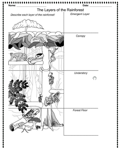
A whole lesson for the Layers of the Rainforest, with lesson plan, success criteria, notebook file and worksheet. Taught to Year 2 and 3 mixed.
ks1 ks2 y1 y2 y3 y4 y5 y6
A freebie lesson about mountains.
Perfect to kick off a topic about anywhere in the world or as the first lesson in a Mountains topic, this lesson creates a great starting point to look at continents and features.
Children will learn about the continents of the world and use atlases (including Google Earth and physical atlases) to explore the world’s mountain ranges and their heights.
The PowerPoint is easy to follow and guides the teacher through from starter, main input to task and plenary.
Resources included:
Lesson plan
PowerPoint
KWL Grid
Mountains Table Template
Previous Knowledge worksheet
World Map to Label
Lesson 1: L.O. To be able to locate mountains in different continents.
Success Criteria:
I can write facts about mountains.
I can name the seven continents of the world.
I can think of questions I want to know the answer to.
I can identify mountain ranges on maps.
y3 y4 y5 y6 lks2 uks2 year 3 year 4 year 5 year 6 geography topic humanities unit lessons atlases atlas features
Welcome to our free resource of Rainforest Sight Words! This colorful and engaging sheet has been designed to help children aged 3-5 to learn and recognize sight words associated with the rainforest. Each word is accompanied by a beautiful picture of an animal, plant or insect that can be found in the rainforest, to provide a fun and visual aid for learning. This resource is perfect for use in the classroom or at home and can be printed out as many times as needed. Your little learners will love practicing their reading skills as they explore the fascinating world of the rainforest!
Have any issues with this resource or a request? Contact us directly for the quickest response at: explore_education@outlook.com
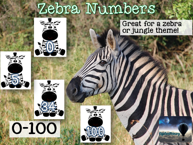
Back to school! Numbers 0-100 on zebras - these are perfect for a zebra themed classroom, display or role play. Also suitable for jungle or animal themes. Make a number line or count up in 2s, 5s, 10s etc. by selecting the pages.
Have any issues with this resource or a request? Contact us directly for the quickest response at: explore_education@outlook.com
School Journeys Around the World assembly - features stories of real life children living in Ecuador and how they travel through the rainforest to get to school. Suitable for KS1 or KS2.
Elevate your geography lessons with this Key Stage 2 lesson focusing on Human and Physical Features. This resource provides a comprehensive package, featuring a lesson plan, a PowerPoint presentation, and engaging activity sheets. Designed to cultivate a deep understanding, students will learn to identify and differentiate between human and physical geographical features on a map. The lesson uses practical application, as children employ their newfound skills to create their own map. For added challenge, an extension activity prompts the identification of features on a map of London using compass points.
Resource Highlights:
★ Lesson Plan: A detailed guide for a seamless teaching experience.
★ PowerPoint: An engaging visual aid to reinforce concepts and spark curiosity.
★ Activity Sheets: Thoughtfully designed sheets for interactive and hands-on learning.
★ Practical Application: Move beyond theory as students create their own maps with identified features.
★ Extension Activity: Challenge students with an additional task that explores features on a map of London using compass points.
You may also be interested in…
☆ KS2 RAINFOREST Geography Unit - 6 Outstanding Lessons
☆ KS2 France Geography Unit - 5 outstanding lessons fully resourced
☆ KS1 Piet Mondrian Painting - Outstanding Art Lesson
Customer Support:
Encountering any challenges or have specific requests? Contact our support team directly at explore_education@outlook.com for a swift response.
Special Offer:
Enjoying this resource? Leave a review and receive a complimentary resource of your choice! Email us your purchase receipt and a screenshot of your review to avail this offer.
Tags: KS2, Key Stage 2, Geography, Human Features, Physical Features, Lesson Plan, PowerPoint, Activity Sheets, Map Identification, London Map, Compass Points, Education.
Are you looking for a fun and engaging way to teach your KS2 students about the physical features of the UK? Do you want to help them develop their geographical skills and knowledge using interactive tools and activities? If so, this outstanding geography lesson is perfect for you!
This resource includes a detailed lesson plan, a captivating powerpoint and a range of activity sheets to support your teaching. In this lesson, your students will:
★ Learn about the different types of physical features of the UK, such as mountains, rivers, lakes, coasts and islands.
★ Watch a video that shows the diverse and beautiful terrain of the UK from different perspectives.
★ Use Google Maps to compare and contrast different areas of the UK and the amount of physical features in each area.
★ Discuss how physical features could affect the use of the area, such as tourism, agriculture, industry and transport.
★ Create a presentation to compare the differences between East Anglia and Cumbria for someone coming to the UK, using a guidelines sheet to help them structure their work.
★ Extend their learning by comparing two other areas of their choice and their physical features, using a template to help them organise their information.
This resource is designed to meet the National Curriculum objectives for geography at KS2, and to develop your students’ curiosity and fascination about the world and its people. It is also suitable for cross-curricular links with English, ICT and PSHE.
Customer Support
If you have any questions or feedback about this resource, please contact us at explore_education@outlook.com. We are always happy to hear from you and to help you make the most of our products.
Special Offer:
We appreciate your feedback on this resource. If you leave a review, you can get another resource of your choice for free! Just send us an email with your purchase receipt and a screenshot of your review to claim your offer.
Tags: KS2, Key Stage 2, Geography, Physical Features, UK, Lesson Plan, PowerPoint, Activity Sheets, Google Maps, Comparative Analysis, Presentation Creation, Education.
Transform your geography lessons with this outstanding KS2 lesson on Compass Directions. This resource is designed to engage and educate, offering a well-structured lesson plan, a PowerPoint presentation, and activity sheets that guide students through the cardinal and intercardinal points of the compass. Beyond theory, this lesson encourages practical application as children utilise their newfound skills to write directions for a journey on a map. An extension activity is included to challenge early finishers.
Resource Highlights:
★ Lesson Plan: A comprehensive guide to ensure a seamless and impactful teaching experience.
★ PowerPoint: A visually engaging presentation that brings the concept of compass directions to life.
★ Activity Sheets: Thoughtfully designed sheets that facilitate hands-on learning and application.
★ Practical Application: Move beyond theory as students apply compass skills to map reading and direction writing.
★ Extension Activity: Challenge early finishers with an additional activity that reinforces the lesson’s objectives.
Customer Support:
Encountering any challenges or have specific requests? Contact our support team directly at explore_education@outlook.com for a swift response.
Special Offer:
Enjoying this resource? Leave a review and receive a complimentary resource of your choice! Email us your purchase receipt and a screenshot of your review to avail this offer.
Tags: KS2, Key Stage 2, Geography, Compass Directions, Cardinal Points, Intercardinal Points, Lesson Plan, PowerPoint, Activity Sheets, Map Reading, Education.
Take your students on an exciting journey through Europe with this outstanding geography lesson! In this comprehensive lesson, students will learn to use compass directions, 4-figure grid references, symbols, and map keys to explore the geography of Europe. Through engaging activities and interactive discussions, students will develop the skills to accurately navigate maps and interpret important geographical information.
The lesson begins with a stimulating starter discussion on the significance of directions and grid references in map exploration. Then, students will be introduced to the 8 points of a compass, understanding their corresponding directions within Europe. A captivating map of Europe will showcase key symbols and a map key, enabling students to grasp the meaning behind these symbols and their representation of various geographical feature.
The lesson continues with three hands-on activities that reinforce learning. In Activity 1, students use small maps of Europe to label the 8 compass points and practice giving directions to specific countries or cities. Activity 2 focuses on 4-figure grid references, where students locate points on their maps and identify corresponding countries or cities. Working individually or in pairs, students enhance their map-reading skills and strengthen their accuracy. In Activity 3, students collaborate in small groups to place symbol cards representing different geographical features on a large map of Europe. Through discussions and referencing the map key, students deepen their understanding of Europe’s geography.
To conclude the lesson, a plenary discussion reviews the concepts covered, allowing students to share their newfound knowledge and showcase their skills by identifying specific countries, cities, or geographical features on a map of Europe. Ongoing assessment throughout the lesson helps monitor students’ participation and understanding.
This outstanding geography lesson comes with a comprehensive set of resources, including a 23-slide PowerPoint presentation, maps of Europe, activity sheets, symbols key, compasses (optional), and answers for convenience. Engage your students’ curiosity and foster their map-reading abilities with this immersive and educational lesson on Europe’s geography.
Delve into Europe’s iconic landmarks with our comprehensive “Europe Geography Lesson - Famous Landmarks” resource. This resource offers a deep exploration of Europe’s cultural heritage through well-known sites like the Eiffel Tower and Big Ben.
Students will develop map skills, historical understanding, and cultural appreciation as they engage in activities such as landmark descriptions, map marking, and travel adventure planning.
The resource includes a PowerPoint presentation, visuals, blank maps, and travel brochures, providing a thorough exploration of Europe’s famous landmarks.
Connect students with Europe’s cultural tapestry through this engaging and informative lesson.
Explore Spain and the UK with our “Comparative Geography Lesson.” This resource helps students compare cultures, trade, and travel. They’ll learn about similarities, analyze connections, and discuss how geography influences everything.
Activities:
☆ Compare traditions and languages.
☆ Explore trade and travel routes.
☆ Understand how geography affects culture, trade, and travel.
The lesson starts with an engaging intro. Then, students learn about Spain and the UK. They compare cultures and trade, discussing geography’s role.
In Activity 1, students work together on cultural cards. They share what’s special about each place. Activity 2 has students tracing routes on maps and discussing connections. Activity 3 explores how geography impacts everything they’ve learned.
The lesson ends with a group discussion. Students share what they’ve discovered. We’ll assess their understanding based on participation, discussing connections, and considering geography.
This resource includes a lesson plan, PowerPointcards, maps, worksheets, and discussion ideas. Help students learn about Europe’s connections with our “Comparative Geography Lesson”!
Explore European geography and culture with our engaging lesson from the European Geography series. This lesson enhances students’ understanding of European countries and their unique characteristics using maps, atlases, globes, and digital tools.
Start with a map activity to identify countries, followed by an exploration of Europe’s diverse landscapes, history, culture, languages, and landmarks. Activities include labeling countries, locating geographical features, and interactive mapping.
Assess engagement, accuracy in locating countries, and understanding of characteristics. Resources include lesson plan, PowerPoint, printed and digital maps, atlases, globes, and digital mapping tools.
Deepen students’ knowledge of European countries and their distinct attributes, fostering appreciation for Europe’s diversity and cultural richness.
Tags: Outstanding, observation, interview, lesson, PowerPoint, year 3
Explore Europe’s geography, cultures, and landmarks with our comprehensive Europe Geography Lesson. This lesson emphasizes the impact of geography on history, culture, and society, fostering critical thinking and cultural awareness.
Activity 1: European Country Hunt
Guess countries based on geographical features, landmarks, or cultural aspects in an interactive game.
Activity 2: Creating a Geography Collage
Select a European country, create collages illustrating its geography, landmarks, and culture.
Activity 3: Travel Brochure Challenge
Research and design travel brochures for assigned European countries, emphasizing geography and attractions.
Students engage in discussions, group activities, and receive feedback. Assess their ability to identify geographical similarities and differences. Resources include lesson plan, PowerPoint, map, visuals, and worksheets. Deepen students’ global awareness with our Europe Geography Lesson.
Explore European geography with our engaging “Europe Geography Lesson” designed for primary students! This resource makes learning about temperature and rainfall differences across various European locations a breeze while developing essential graphing skills.
What’s Included:
PowerPoint, lesson plan and worksheets
Clearly defined learning objectives and success criteria to guide students through the process of collecting and analyzing data from different European regions.
Students create simple and clear graphs to represent their data, allowing for easy comparisons and insights into environmental trends in Europe.
Interactive starter activity to highlight the importance of understanding European geography, where students can share their prior knowledge of temperature and rainfall.
Main segment introduces data sets containing temperature and rainfall information, teaching students how to read units of measurement and patterns.
Activity 1 involves small group work where students analyze specific data sets, identifying significant temperature and rainfall patterns, discussing findings, and making predictions.
Activity 2 guides students in creating basic graphs using graph paper or software, emphasizing clear labeling and appropriate scales.
Activity 3 leads to a class discussion where groups share and compare their graphs, identifying similarities, differences, and exploring possible reasons behind observed patterns.
Plenary activity helps students reflect on their learning journey and share conclusions about the environmental conditions in selected European locations.
This comprehensive resource provides all the necessary materials to effectively engage primary students, including data sets, graphing tools, and discussion prompts. Make European geography fun and educational with our captivating Europe Geography Lesson!
Explore European geography with our comprehensive lesson on Equator, Hemispheres, Time Zones, and key areas. This resource covers Europe’s unique characteristics, climate, seasons, and time differences’ impact on travel.
Learn about latitude lines, regions, and key geographical areas globally and in Europe. Activities include labeling maps, analysing climate charts, and a time zone travel challenge to calculate arrival times across Europe.
The lesson wraps up with an interactive trivia game. It includes a lesson plan, PowerPoint, printable maps, climate charts, and trivia cards. Engage students with clear learning objectives and activities, fostering curiosity about geography.
KS2 KS3 LKS2 UKS2 year 3 year 4 year 5 year 6 y3 y4 y5 y6 ofsted interview outstanding
Explore Europe with our outstanding Geography Lesson! Students will learn about different parts of Europe, share their thoughts, and have meaningful discussions about climate, landmarks, culture, and what interests them.
We start with a fun activity to get students thinking about European places they know or want to visit. Then, we dive into the main part of the lesson, using exciting pictures and videos to understand how these places affect our opinions.
In Activity 1, students make collages of their favorite European spots and show them to the class. Activity 2 has small groups talking about their dream European holidays while thinking about what we’ve learned. Finally, in Activity 3, students present their top European pick with facts or stories.
At the end, students walk around to see each other’s work and think about what they’ve learned. During the lesson, students practice sharing ideas, having good conversations, and showing what they think in a clear way. They’ll also learn more about Europe’s geography and culture.
ks2 ks3 uks2 lks2 y3 y4 y5 y6 year 3 year 4 year 5 year 6 ks3 y7 y8 outstanding humanities ofsted interview observation supply teacher no prep
Have any issues with this resource or a request? Contact us directly for the quickest response at: explore_education@outlook.com
A lesson about longitude and latitude for geography. All resources provided. This lesson has been successfully used for a lesson observation and includes an interactive PowerPoint, worksheets, resources, planning and video song.
L.O. To learn to identify the position and significance of the lines of Latitude, Longitude, Tropic of Cancer, Capricorn and Equator.
Success Criteria:
I can differentiate between weather and climate.
I can label lines of Latitude, Longitude and the Tropics.
I can explain what the lines are used for and their direction.
I can create sentences about countries using the lines to describe their whereabouts.
Resources Included:
PowerPoint
Lesson Plan
Starter Task Worksheet
World Map Activity
Coordinates for main activity
Writing task
Success Criteria Strip
Longitude and latitiude song video
Extension task
WAGOLL Example Map
Sentence starters for LA
Word bank
Tags: ks2 ks3 y3 y4 y5 y6 humanities atlas map mapping weather climate nqt ect interview Climate change Travel and tourism What is Geography Structure of the earth year 3 year 4 year 5 year 6 longitude and latitude ks2 worksheet ppt finder google maps calculator meaning london games tes activity song display teaching latitude and longitude topic
Do you want to provide your students with some fun and engaging homework activities that relate to the theme of Africa? Do you want to cover different subjects such as geography, history, science, maths, writing, and reading? If so, this Africa Homework Choice Board is perfect for you!
This product contains a choice board of 30 tasks that span across various subjects and skills. Your students can choose which tasks they want to complete and how many they want to do each week. The tasks are designed to be creative, challenging, and relevant to the theme of Africa.
Some examples of the tasks are:
★ Research an African animal and create a poster with at least four facts.
★ Record the heights of 5 mountains in Africa and present in a bar chart. Which is the tallest? By how much?
This pack also includes a PDF of 54 African flags to decorate and a factfile worksheet. You can use this product as a whole-class homework project or as a differentiated option for individual students.
This Africa Homework Pack is a great way to extend your students’ learning beyond the classroom and to make homework more enjoyable and meaningful. Download it today and let your students explore the wonderful world of Africa!
Tags: ks2 lks2 year 3 year 4 year 5 year 6 uks2 geography home learning remote
Are you looking for some fun and engaging homework activities for your KS1 students? Do you want to explore the theme of the seaside across different subjects? If so, this Beside the Seaside Homework Grid is perfect for you!
This resource contains a grid of 44 tasks that cover geography, history, science, maths, writing, and reading. Your students can choose which tasks they want to complete and how many they want to do each week. The tasks are designed to be creative, challenging, and relevant to the seaside topic.
Some examples of the tasks are:
★ Write a story about a day at the beach.
★ Create a bar graph showing the number of ice creams sold at a seaside shop.
★ Make a sundial and track the movement of the sun throughout the day.
This resource also includes a parent letter that explains the homework grid and a record sheet for students to keep track of their completed tasks. You can use this resource as a whole-class homework project or as a differentiated option for individual students.
This Beside the Seaside Homework Grid is a great way to extend your students’ learning beyond the classroom and to make homework more enjoyable and meaningful. Download it today and let your students dive into the wonderful world of the seaside!
Need a lesson all about tornadoes? This practical lesson is an outstanding way to teach children about how tornadoes are formed using easy to source materials.
This lesson comes with a detailed lesson plan, PowerPoint, worksheets, word bank, extension task and plenary.
Files included:
✸ Lesson plan
✸ PowerPoint
✸ Pictures of tornado in a cup
✸ Extension task
✸ Word bank
L.O. To become familiar with what a tornado is and how it is formed.
Success Criteria:
I can create a tornado in a glass using lemonade and salt.
I can use the practical task to explain how a tornado is formed and how it works.
I can create quiz style questions for the class based on tornadoes and using books from the reading corner.
**Have any issues with this resource or a request? Contact us directly for the quickest response at: explore_education@outlook.com
Tags: interview ofsted ks2 ks3 y3 y4 y5 y6 humanities atlas map mapping weather climate nqt ect interview Climate change Weather Travel and tourism What is Geography Structure of the earth extreme earth earthquakes world uk tornadoes for kids tornados facts worksheet tornadoes lesson explanation ppt assessment