Thank you for visiting! Here you will find a selection of printable, interactive worksheets for your classroom: Basic Geography worksheets with simple maps, ESL, Spanish, Bible, Reading Comprehension and more. I hope you find the resources useful! Reviews are welcome and very much appreciated. Thank you so much.
Thank you for visiting! Here you will find a selection of printable, interactive worksheets for your classroom: Basic Geography worksheets with simple maps, ESL, Spanish, Bible, Reading Comprehension and more. I hope you find the resources useful! Reviews are welcome and very much appreciated. Thank you so much.
Color the map of Europe. Printable handout of 1 page includes a map of Europe to color and learn.
Countries of Europe included: Albania, Andorra, Armenia, Austria, Azerbaijan, Belarus, Belgium, Bosnia and Herzegovina, Bulgaria, Croatia, Cyprus, Czech Republic, Denmark, Estonia, Finland, France, Georgia, Germany, Greece, Hungary, Iceland, Ireland, Italy, Kazakhstan, Kosovo, Latvia, Lithuania, Luxembourg, Macedonia, Malta, Moldova, Monaco, Montenegro, Netherlands, Norway, Poland, Portugal, Romania, Russia, San Marino, Serbia, Slovakia, Slovenia, Spain, Sweden, Switzerland, Turkey, Ukraine, United Kingdom, Vatican City.
Thank you for using my Geography worksheets in your classroom! I hope you find them useful. Reviews are welcome and very much appreciated. Please browse this store for a selection of worksheets to introduce your students to the countries of the world!
Using the map of the Middle East, find the 17 countries in this Word Search Puzzle. They can be found forward or backward. Countries included: Bahrain, Cyprus, Egypt, Iran, Iraq, Israel, Jordan, Kuwait, Lebanon, Oman, Palestine, Qatar, Saudi Arabia, Syria, Turkey, UAE (United Arab Emirates), Yemen. One printable worksheet (plus answer key).
Thank you so much for using my Geography worksheets in your classroom!
Please browse this store for a selection of printable worksheets for each country of the Middle East (and beyond!).
Introduce your students to ISRAEL with this printable handout of two worksheets (plus answer key). Your students will read a brief introduction to Israel (location, capital, flag, language), write ‘Jerusalem’ next to the star on the map to show the location of the capital, color the small map, and use the map and compass to answer 9 questions on page 2. Colored pencils and a pen or pencil are needed for this activity. No other prep needed. Basic Geography worksheet with a simple map to introduce Israel and practice cardinal/ordinal directions.
For use with Interactive Notebooks: After the worksheets are completed, students can cut out the map and flag and paste into the notebook under the topic of Asia / Sub-topic: Israel. Under the map and flag, your students can write a summary in their own words of what they now know about Israel. Collect handouts for other countries of Asia to add to the notebook! Please browse this store for a selection of worksheets for all other countries of Asia (and beyond)!
Thank you so much for using my Geography worksheets in your classroom! I hope you find them useful. Reviews are welcome and very much appreciated.
Included: Mediterranean Sea, Red Sea, Dead Sea, Holy Land, Lebanon, Syria, Jordan, Egypt, Saudi Arabia, Tel Aviv, Bethlehem, Nazareth, Palestinian territories West Bank and Gaza, Star of David, Tallit.
Introduce your students to Japan with this printable handout of two worksheets (plus answer key). Your students will read a brief introductin to Japan (location, capital, flag, language), write ‘Tokyo’ next to the star on the map to show the location of the capital, color the small map and flag, and use the map and compass to answer 7 questions on page 2. Colored pencils and a pen or pencil are needed for this activity. No other prep needed. Basic Geography worksheet with a simple map to introduce Japan and practice cardinal and ordinal directions.
For use with Interactive Notebooks: After the worksheets are completed, students can cut out the map and flag and paste into the notebook under the topic of Asia / Sub-Topic: Japan. Under the map and flag, your students can write a summary in their own words of what they now know about this country. Collect handouts for other countries of Asia to add to the notebook! Please browse this store for a selection of worksheets for all other countries of Asia (and beyond!)
Thank you so much for using my Geography worksheets in your classroom! I hope you find them useful. Reviews are welcome and very much appreciated!
Japanese Archipelago, Islands of Honshu, Hokkaido, Kyushu, Shikoku.
Nisshōki, Hinomaru, Maritime borders. Dialect. Okinawa, Ryukyu Islands.
Introduce your students to Poland with this printable handout of 2 worksheets (plus answer key). Your students will read a brief introduction to Poland (location, capital, flag, language), write 'Warsaw' next to the star on the map to show the location of the capital, color the small map and flag, and use the map and compass to answer 7 questions on page 2. Colored pencils and a pen or pencil are needed for this activity. No other prep needed. Basic Geography worksheet with a simple map to introduce Poland and practice cardinal and ordinal directions.
For use with Interactive Notebooks: After the worksheets for Poland are completed, students can cut out the map and flag and paste into the notebook under the topic of Europe/Sub-Topic: Poland. Under the map, your students can write a summary in their own words of what they now know about Poland. Collect worksheets for other countries of Europe to add to the notebook! Please browse this store for worksheets for other countries of Europe - and beyond!
Thank you so much for using my Geography worksheets in your classroom! I hope you find them useful and fun. Reviews are welcome and very much appreciated!
Introduce your students to the 20 regions and capital cities of Italy with three worksheets (plus answer key). Using the list of regions and capitals on page 2, your students will write the capital city of each region on the map of Italy (page 1). Then answer 8 true/false questions on page 3.
Regions/Capitals included:
Region - Capital
Abruzzo - L’Aquila
Basilicata - Potenza
Calabria - Catanzaro
Campania - Naples
Emilia-Romagna - Bologna
Friuli-Venezia Giulia - Trieste
Lazio - Rome
Liguria - Genoa
Lombardy - Milan
Marche - Ancona
Molise - Campobasso
Piedmont - Turin
Puglia - Bari
Sardinia - Cagliari
Sicily - Palermo
Tuscany - Florence
Trentino-Alto Adige - Trento
Umbria - Perugia
Valle d’Aosta - Aosta
Veneto - Venice
Thank you so much for using my worksheets in your classroom! I hope you find them useful. Reviews are welcome and very much appreciated.
Mexico is located south of the United States and north of Central America. Introduce your learners to Mexico and surrounding with this printable map activity! Two worksheets (plus answer key).
Page 1:
FILL IN THE BLANKS on the map for each of the following: Alabama, Arizona, Arkansas, Atlantic Ocean, Belize, California, Caribbean Sea, Costa Rica, Cuba, El Salvador, Florida, Georgia, Guatemala, Gulf of Mexico, Honduras, Louisiana, Mexico, Mississippi, New Mexico, Nicaragua, Oklahoma, Pacific Ocean, Panama, South Carolina, Texas.
COLOR CODE: Choose a color for the United States, Mexico, Central America, and Bodies of Water. Then color the map.
Page 2: Use your completed map and compass to answer 7 questions.
Page 3: Answer Key.
Colored pencils and a pen or pencil are needed for this activity. No other prep needed.
Thank you so much for using my printables with your learners! I hope you find them useful. Reviews are welcome and very much appreciated. Please browse this store for more worksheets to introduce your learners to the countries of the world!
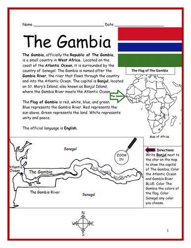
Introduce your students to THE GAMBIA in Africa with this printable handout of two worksheets (plus answer key). Your students will read a brief introduction to The Gambia (location, capital, flag, language), write ‘Banjul’ next to the star on the map to show the capital, color the small map, and use the map and compass to answer 7 questions on page 2. Colored pencils and a pen or pencil are needed for this activity. No other prep needed. Basic Geography worksheet includes a simple map to introduce The Gambia and practice cardinal/ordinal directions.
For use with Interactive Notebooks: After the worksheets are completed, students can cut out the map and flag and paste into the notebook under the topic of Africa/Sub-topic: The Gambia. Under the map and flag, your students can write a summary in their own words of what they now know about this country. Collect handouts for other countries of Africa to add to the notebook! Please browse this store for a selection of printable Geography worksheets for other countries of Africa (and beyond!).
Thank you so much for using my Geography worksheets in your classroom! I hope you find them useful. Reviews are welcome and very much appreciated!
Teach your students about Cuba with this printable handout of 2 worksheets (plus answer key). Your students will read a brief overview of Cuba (location, capital, flag), write ‘Havana’ next to the star on the map to show the capital, then colour the flag and map of Cuba and surrounding. Then they will use the map and compass to answer 5 multiple-choice questions on page 2.
Four use with Interactive Notebooks: After the handout is completed and the map and flag are coloured, cut out the map, flag and compass and paste into the notebook under the topic of CUBA. Under the map, your students will write a summary in their own words of what they now know about Cuba.
Thank you four using my Geography worksheets in your classroom!
Cuba and surrounding: Jamaica, Haiti, Dominican Republic, Mexico, Belize, Guatemala, Honduras, United States, Florida, the Bahamas, Caribbean Sea, Atlantic Ocean, Gulf of Mexico. North America, Central America. Cardinal, ordinal directions. Isla dae la Juventud.
Note: This handout is in British English. For American English, please visit this link:
Using the map of the continent of Oceania, find the 14 island countries in the Word Search Puzzle. They can be found forward or backward. One printable worksheet (plus answer key). Countries included: Australia, Papua New Guinea, New Zealand, Fiji, Solomon Islands, Vanuatu, Samoa, Kiribati, Micronesia, Tonga, Marshall Islands, Palau, Tuvalu, Nauru.
Thank you so much for using my Geography worksheets! I hope you find them useful. Reviews are welcome and very much appreciated. Please browse this store for more Geography worksheets and Word Search Puzzles.
Find the 21 Spanish-Speaking Countries in the Word Search Puzzle! One printable Word Search Puzzle (plus answer key).
Countries to find in the Word Search Puzzle: Argentina, Bolivia, Chile, Colombia, Costa Rica, Cuba, Dominican Republic, Ecuador, El Salvador, Equatorial Guinea, Guatemala, Honduras, Mexico, Nicaragua, Panama, Paraguay, Peru, Puerto Rico, Spain Uruguay, Venezuela.
Flags for each country included!
Please browse this store for other worksheets to introduce your learners to the Spanish-Speaking Countries! SPANISH-SPEAKING COUNTRIES FILL IN THE BLANKS, SPANISH-SPEAKING COUNTRIES SCRAMBLE, and more! Worksheets also available to introduce your learners to each Spanish-Speaking country!
Thank you so much for using my worksheets in your classroom! I hope you find them useful and fun. Reviews are welcome and very much appreciated. Please FOLLOW THIS STORE!!
Introduce your students to Spain with two worksheets (plus answer key). Your students will read a brief introduction to Spain (location, capital, flag, language), write ‘Madrid’ next to the star on the map to show the location of the capital, color the flag and map, and use the map and compass to answer 7 questions on page 2. Colored pencils and a pen or pencil are needed for this activity. No other prep needed. Basic Geography worksheet includes a simple map to introduce Spain and practice cardinal/ordinal directions.
For use with Interactive Notebooks: After completing the worksheets, students can cut out the map and flag and paste into the notebook under the topic of Europe (or Spanish-Speaking Countries), Sub-Topic: Spain. Under the map and flag, students can write a summary in their own words of what they now know about this country. Collect worksheets for other countries of Europe to add to the notebook! Please browse this store for a selection of worksheets for other countries of Europe (and beyond!).
Thank you so much for using my worksheets in your classroom! I hope you find them useful. Reviews are welcome and very much appreciated.
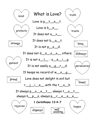
Printable activity/coloring page for 1 Corinthians 13:4-7. What is love? Fill in the blank letters for each word to complete the bible verse.
Love is patient, love is kind. It does not envy, it does not boast, it is not proud. It does not dishonor others, it is not self-seeking, it is not easily angered, it keeps no record of wrongs. Love does not delight in evil but rejoices with the truth. It always protects, always trusts, always hopes, always perseveres.
1 Corinthians 13:4-7 (NIV)
Thank you so much! God bless!
Introduce your students to the country of SOUTH AFRICA with two worksheets (plus answer key). Your students will read a brief introduction to South Africa (location, capitals, flag, language), write ‘Pretoria’ next to the ‘A’ on the map to show the administrative capital; write ‘Bloemfontein’ next to the ‘J’ to show the judicial capital; write ‘Cape Town’ next to the ‘L’ on the map to show the legislative capital, color the small map, and use the map and compass to answer 9 questions on page 2. Basic Geography Worksheet with a simple map to introduce South Africa and practice cardinal and ordinal directions. Colored pencils and a pen or pencil are needed for this activity.
For use with Interactive Notebooks: After the worksheets are completed, students can cut out the map and flag and paste into the notebook under the topic of Africa / Sub-Topic: South Africa. Under the map, students can write a summary in their own words of what they now know about this country. Collect worksheets for other countries of Africa to add to the notebook! Please browse this store for a selection of worksheets for other countries of Africa (and beyond!).
Thank you so much for using my Geography worksheets in your classroom! I hope you find them useful. Reviews are welcome and very much appreciated.
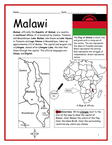
Introduce your students to MALAWI in Africa with this printable handout of two worksheets (plus answer key). Your students will read a brief introduction to Malawi (location, capital, flag, language), write ‘Lilongwe’ next to the star on the map to show the capital, color the small map, and use the map and compass to answer 7 questions on page 2. Colored pencils and a pen or pencil are needed for this activity. No other prep needed. Basic Geography worksheet includes a simple map to introduce the country of Malawi and practice cardinal/ordinal directions.
For use with Interactive Notebooks: After the worksheets are completed, students can cut out the map and flag and paste into the notebook under the topic of Africa/Sub-topic: Malawi. Under the map and flag, your students can write a summary in their own words of what they now know about this country. Collect worksheets for other countries of Africa to add to the notebook! Please browse this store for a selection of printable worksheets for other countries of Africa (and beyond!).
Thank you so much for using my Geography worksheets in your classroom! I hope you find them useful. Reviews are welcome and very much appreciated!
Introduce your learners to Kenya with two worksheets (plus answer key). Your students will read a brief introduction to Kenya (location, capital, flag, language), write ‘Nairobi’ next to the star on the map to show the location of the capital, trace the line of the equator across Kenya, color the small map and flag, and use the map and compass to answer 9 questions on page 2. Colored pencils and a pen or pencil are needed for this activity. No other prep needed. Basic Geography worksheet with a simple map to introduce Kenya and practice cardinal and ordinal directions.
For use with Interactive Notebooks: After the worksheets are completed, students can cut out the map and flag and paste into the notebook under the topic of Africa / Sub-Topic: Kenya. Under the map and flag, students can write a summary in their own words of what they now know about this country. Collect worksheets for other countries of Africa to add to the notebook! Please browse this store for a selection of worksheets for other countries of Africa (and beyond!).
Thank you so much for using my Geography worksheets in your classroom! Reviews are welcome and very much appreciated.
Introduce your students to the Netherlands (Holland) with two worksheets (plus answer key). Your students will read a brief introduction to the Netherlands (location, capital, flag, language), write ‘Amsterdam’ next to the star on the map to show the location of the capital, color the small map and flag, and use the map and compass to answer five questions on page 2. Colored pencils and a pen or pencil are needed for this activity. No other prep needed. Basic Geography worksheet with a simple map to introduce the Netherlands and practice cardinal and ordinal directions.
For use with Interactive Notebooks: After the worksheets are completed, students can cut out the map and flag and paste into the notebook under the topic of Europe / Sub-Topic: The Netherlands. Under the map, your students can write a summary in their own words of what they now know about the this country. Collect worksheets for other countries of Europe to add to the notebook! Please browse this store for a selection of worksheets for other countries of Europe (and beyond!).
Thank you so much for using my Geography worksheets in your classroom! I hope you find them useful. Reviews are welcome and very much appreciated. :)
Introduce your students to ICELAND with two worksheets (plus answer key). Your students will read a brief overview of Iceland (location, capital, flag, language), write ‘Reykjavík’ next to the star on the map to show the location of the capital, color the map, and use the map and compass to answer 6 questions on page 2. Colored pencils and a pen or pencil are needed for this activity. No other prep needed. Basic Geography worksheet with a simple map to introduce Iceland and practice cardinal/ordinal directions.
For use with Interactive Notebooks: After completing the worksheets, students can cut out the map and flag and paste into the notebook under the topic of Europe / Sub-Topic: Iceland. Under the map and flag, students can write a summary in their own words of what they now know about this country. Collect worksheets for other countries of Europe to add to the notebook! Please browse this store for worksheets for other countries of Europe (and beyond!).
Thank you so much for using my worksheets in your classroom! I hope you find them useful. Reviews are welcome and very much appreciated!
Introduce your learners to Bulgaria in Europe with two printable worksheets (plus answer key). Your students will read a brief introduction to Bulgaria (location, capital, flag, language), write ‘Sofia’ next to the star on the map to show the location of the capital, color the small map and flag, and use the map and compass to answer 6 questions on page 2. Colored pencils and a pen or pencil are needed for this activity. No other prep needed. Basic Geography worksheet with a simple map to introduce Bulgaria and practice cardinal and ordinal directions.
For use with Interactive Notebooks: After completing the worksheets, students can cut out the map and flag and paste into the notebook under the topic of Europe/Sub-Topic: Bulgaria. Under the map and flag, students can write a summary in their own words of what they now know about this country. Collect worksheets for other countries of Europe to add to the notebook! All available in this store! Please browse this store for a selection of worksheets for other countries of Europe (and beyond!)
Thank you so much for using my Geography worksheets in your classroom. I hope you find them useful. Reviews are welcome and very much appreciated!
Included: North Macedonia, Greece, Turkey, Romania, Serbia, Black Sea, Aegean Sea, Sea of Marmara
Teach Spanish and English to beginners with this printable dual-language, interactive picture dictionary. This includes 54 printable handouts with over 200 everyday, basic vocabulary words in Spanish and English with pictures to color and learn. Words are grouped into 25 topics with 6-9 pictures to color on each page, followed by a Word Review page. Teachers can cover one topic at a time. Students will save all completed handouts and staple it into a book to keep. A Cover Page, Table of Contents, and Index are included. Colored pencils or crayons are needed for this activity. No other prep needed.
Topics include:
English: bathroom, classroom, clothing, communication, containers, face, farm animals, foot, fruit, hand, kitchen, kitchen items, living room, nature, numbers, pets, sports, summer, table setting, tools, traffic light, transportation, vegetables, verbs, wild animals, winter.
Español: el baño, el salón de clases, la ropa, comunicación, contenedores, la cara, animales de la granja, el pie, la fruta, la mano, la cocina, cosas de la cocina, la sala, la naturaleza, los numeros, mascotas, los deportes, el verano, en la mesa, herramientas, el semáforo, el transporte, las verduras, verbos – acciones, animales salvajes, el invierno
Reinforce new vocabulary in Spanish and English with supplemental packets! Please click on the following links for supplemental worksheets to use with this book:
VEGETABLES / LAS VERDURAS : https://www.tes.com/teaching-resource/spanish-and-english-vegetables-12005291
NUMBERS 1-10: https://www.tes.com/teaching-resource/bilingual-numbers-1-10-spanish-and-english-12014759
The supplemental packets include 7 printable worksheets to use after completing the topic with the bilingual picture dictionary. With this supplemental packet, your students will read and write each new word, match the word in English and Spanish with the correct picture, find all new words in the Word Search, Fill-in-the-Blanks, and take the quiz. Answer key included in each packet.**
Thank you so much for using my worksheets in your classroom!
Illustrations used with permission from Pro Lingua Associates, publisher of 'Coloring in English - A Vocabulary Builder for Beginners, by Tracy Speelman. Coloring in English includes 400 everyday, basic vocabulary words in English with pictures to color and learn: http://www.prolinguaassociates.com/
Translations by Javier Morales, Bilingual Special Education Advocate and Founder of Parents Ask - Understanding Disabilities One Question at a Time. https://parentsask.net/