Thank you for visiting! Here you will find a selection of printable, interactive worksheets for your classroom: Basic Geography worksheets with simple maps, ESL, Spanish, Bible, Reading Comprehension and more. I hope you find the resources useful! Reviews are welcome and very much appreciated. Thank you so much.
Thank you for visiting! Here you will find a selection of printable, interactive worksheets for your classroom: Basic Geography worksheets with simple maps, ESL, Spanish, Bible, Reading Comprehension and more. I hope you find the resources useful! Reviews are welcome and very much appreciated. Thank you so much.
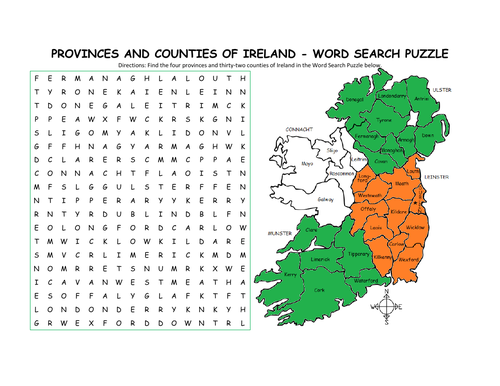
Using the map of Ireland, find the four provinces and thirty-two counties of Ireland in the Word Search Puzzle! They can be found forward or backward.
Provinces and Counties included:
Connacht: Galway, Leitrim, Mayo, Roscommon, Sligo
Ulster: Antrim, Armagh, Cavan, Donegal, Down, Fermanagh, Londonderry, Monaghan, Tyrone
Munster: Cork, Kerry, Limerick, Tipperary, Waterford, Clare
Leinster: Carlow, Dublin, Kildare, Kilkenny, Laois, Longford, Louth, Meath, Offaly, Westmeath, Wexford, Wicklow
One printable word search puzzle (plus answer key).
You may also be interested in:
IRELAND - INTRODUCTORY GEOGRAPHY WORKSHEET
IRELAND - PROVINCES AND COUNTIES INTRODUCTORY WORKSHEET
Thank you so much for using my Geography worksheets to introduce your learners to the countries of the world! I hope you find them useful. Reviews are welcome and very much appreciated.
Teach your students about Africa with this packet of 7 printable worksheets.
Page 1 is a list of the 54 countries of Africa in alphabetical order.
Page 2 is a map of Africa. Your students will write the name of each country on the map.
Page 3: Word Search: Find African countries A-L.
Page 4: Word Search: Find African countries M-Z.
Pages 5-6: List the 54 countries of Africa A-Z (your students will see how many they can remember on their own before referring to the list and map).
Page 7: Languages of Africa. Fill in the blank.
Thank you for using my Geography worksheets in your classroom!
Introduce your students to Mexico with two printable worksheets (plus answer key). Your students will read a brief introduction to Mexico (location, capital, flag, language), write ‘Mexico City’ next to the star on the map to show the location of the capital, write ‘U.S.’ in each state of the United States, write ‘C.A.’ in each country of Central America, color the map and flag of Mexico, and use the map and compass to answer 7 questions on page 2. Colored pencils and a pen or pencil are needed for this activity. No other prep needed. Basic Geography worksheet with a simple map to introduce Mexico and practice cardinal and ordinal directions.
For use with Interactive Notebooks: After the worksheets are completed, students can cut out the map and flag and paste into the notebook under the topic of (example): Spanish-Speaking Countries / Sub-Topic: Mexico. Under the map, your students can write a summary in their own words of what they now know about this country. Collect worksheets for other Spanish-speaking countries to add to the notebook! All available in this store!
Thank you so much for using my worksheets in your classroom! I hope you find them useful. Reviews are welcome and very much appreciated! Please browse this store for a selection of worksheets to introduce your learners to the countries of the world!
Introduce your learners to Ireland with this printable handout of two worksheets (plus answer key). Your students will read a brief overview of Ireland (location, capital, flag, language), write ‘Dublin’ next to the star on the map to show the location of the capital, color the small map and flag, and use the map and compass to answer 6 multiple-choice questions on page 2. Colored pencils or and a pen or pencil are needed for this activity. No other prep needed. Basic Geography worksheet with a simple map to introduce the country of Ireland.
For use with Interactive Notebooks: After completing the worksheets, students can cut out the map and flag and paste it into the notebook under the topic of Europe / Sub-Topic: Ireland. Under the map, students will write a summary in their own words of what they now know about this country. Collect worksheets for other countries of Europe to add to the notebook! Please browse this store for a selection of worksheets for other countries of Europe (and beyond!).
Thank you so much for using my Geography worksheets in your classroom! I hope you find them useful. Reviews are welcome and very much appreciated.
Introduce your students to PORTUGAL with two worksheets (plus answer key). Your students will read a brief introduction to Portugal (location, capital, flag, language), write ‘Lisbon’ next to the star on the map to show the location of the capital, color the small flag and map, and use the map and compass to answer 6 questions on page 2. Colored pencils and a pen or pencil are needed for this activity. No other prep needed. Basic Geography worksheet with a simple map to introduce Portugal and practice cardinal and ordinal directions.
For use with Interactive Notebooks: After completing the worksheets, students can cut out the map and flag and paste into the notebook under the topic of Europe / Sub-Topic: Portugal. Under the map and flag, students can write a summary in their own words of what they now know about this country. Collect worksheets for other countries of Europe to add to the notebook! Please browse this store for worksheets for other countries of Europe (and beyond!).
Thank you so much for using my Geography worksheets in your classroom. I hope you find them useful! Reviews are welcome and very much appreciated.
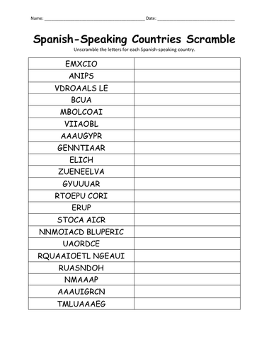
Unscramble each Spanish-speaking country using the list of countries on page 2. Countries included: Argentina, Bolivia, Chile, Colombia, Costa Rica, Cuba, Dominican Republic, Ecuador, El Salvador, Equatorial Guinea, Guatemala, Honduras, Mexico, Nicaragua, Panama, Paraguay, Peru, Puerto Rico, Spain Uruguay, Venezuela. Answer key included.
Thank you so much for using my handouts in your classroom!
Introduce your students to the country of SENEGAL in West Africa with this printable handout of two worksheets (plus answer key). Your students will read a brief overview of Senegal (location, capital, flag, language), write ‘Dakar’ next to the star on the map to show the capital, write ‘Casamance’ in the area of Senegal south of The Gambia, color the small map, and use the map and compass to answer 10 questions on page 2. Colored pencils and a pen or pencil are needed for this activity. No other prep needed. Basic Geography worksheet with a simple map to introduce the country of Senegal and practice cardinal/ordinal directions.
For use with Interactive Notebooks: After the handout is completed, students can cut out the map and flag and paste into the notebook under the topic of Africa/Sub-topic: Senegal. Under the map and flag, your students can write a summary in their own words of what they now know about this country. Collect handouts for other countries of Africa to add to the notebook! Please browse this store for a selection of printable handouts for other countries of Africa (and beyond!).
Thank you so much for using my Geography worksheets in your classroom!
Introduce your learners to Papua New Guinea in Oceania with two worksheets (plus answer key). Your students will read a brief introduction to Papua New Guinea (location, capital, flag, islands, language), locate and circle Papua New Guinea on the map of Oceania, write ‘Port Moresby’ next to the star on the map of Papua New Guinea to show the location of the capital, color the small map, and use the maps and compass to answer 10 true/false questions on page 2. Colored pencils and a pen or pencil are needed for this activity. No other prep needed. Basic Geography worksheet with a simple map to introduce the country of Papua New Guinea and practice cardinal and ordinal directions.
For use with Interactive Notebooks: After the worksheets are completed, students can cut out the map and flag and paste into the notebook under Oceania/Sub-Topic: Papua New Guinea. Under the map and flag, students can write a summary in their own words of what they now know about this country. Collect worksheets for other countries of Oceania to add to the notebook! Please browse this store for a selection of worksheets for other countries of Oceania (and beyond!).
Thank you so much for using my Geography worksheets in your classroom! I hope you find them useful. Reviews are welcome and very much appreciated!
Introduce your students to the 20 regions and capital cities of Italy with three worksheets (plus answer key). Using the list of regions and capitals on page 2, your students will write the capital city of each region on the map of Italy (page 1). Then answer 8 true/false questions on page 3.
Regions/Capitals included:
Region - Capital
Abruzzo - L’Aquila
Basilicata - Potenza
Calabria - Catanzaro
Campania - Naples
Emilia-Romagna - Bologna
Friuli-Venezia Giulia - Trieste
Lazio - Rome
Liguria - Genoa
Lombardy - Milan
Marche - Ancona
Molise - Campobasso
Piedmont - Turin
Puglia - Bari
Sardinia - Cagliari
Sicily - Palermo
Tuscany - Florence
Trentino-Alto Adige - Trento
Umbria - Perugia
Valle d’Aosta - Aosta
Veneto - Venice
Thank you so much for using my worksheets in your classroom! I hope you find them useful. Reviews are welcome and very much appreciated.
ntroduce your students to Brazil with this printable handout of two worksheets (plus answer key). Your students will read a brief overview of Brazil (location, capital, flag, language), write 'Brasília' next to the star on the map to show the capital, write the national motto of Brazil 'ERDEM E PROGRESSO' on the band of the flag, color the flag and map, and use the map and compass to answer 9 questions on page 2. Basic Geography worksheet with a simple map to introduce Brazil and practice cardinal and ordinal directions.
For use with Interactive Notebooks: After the handout is completed, cut out the map and flag and paste into the notebook under the topic of South America/Sub-Topic Brazil. Under the map and flag, your students will write a summary in their own words of what they now know about Brazil. Collect handouts for other countries of South America to add to the notebook! Please browse this store for a selection of printable handouts for other countries of South America (and beyond!).
Thank you so much for using my Geography worksheets in your classroom!
coloring page, cardinal, ordinal, Portuguese
Introduce your students to CHILE in South America with this printable handout of two worksheets (plus answer key). Your students will read a brief overview of Chile (location, capital, flag, language), write 'Santiago' next to the star on the map to show the capital, color the small map, and use the map and compass to answer 8 questions on page 2. Basic Geography worksheet with a simple map to introduce Chile and practice cardinal and ordinal directions.
For use with Interactive Notebooks: After the handout is completed, students can cut out the map and paste into the notebook under the topic South America/Sub-Topic Chile. Under the map, your students will write a summary in their own words of what they now know about Chile. Collect handouts for each country of South America to add to the notebook! Please browse this store for a selection of printable handouts for other countries of South America (and beyond!).
Thank you so much for using my Geography worksheets in your classroom!
Drake Passage, Juan Fernández, San Félix, Isla Salas y Gómez, Easter Island.
Teach FRUIT in SPANISH with this printable packet of 6 worksheets (answer key included). This packet can be used as a supplement to the printable book (My Spanish Picture Dictionary), or on its own. No prep needed. Fruits included: apple, banana, orange, pear, strawberry, cherry, grape, pineapple, lemon. - el limón, la cereza, la manzana, el plátano, la pera, la uva, la pina, la naranja, la fresa
Pages 1 and 2: Your students will read and write the word in Spanish next to the picture of each fruit.
Page 3: Match the picture of each fruit with the correct word.
Page 4: Word Search: Find the name of each fruit in Spanish.
Page 5: QUIZ: Write the word in Spanish next to each fruit.
Page 6: Answer Key.
This printable handout includes a Spanish Pronunciation Quick Guide for vowels and consonants with 5 words and pictures to practice. Directions: Use the Spanish Pronunciation Guide on the left to pronounce the words on the right.
Words/Pictures included in Spanish:
chicken - la gallina
frog - la rana
carrot - la zanahoria
hammer - el martillo
bathtub - la bañera
This is a great activity to prepare your students to increase their Spanish vocabulary. From here, your students can begin creating their own Spanish Picture Dictionary and continue to expand vocabulary with use of this pronunciation guide. For more information, please visit ‘My Spanish Picture Dictionary’ https://www.tes.com/teaching-resource/my-spanish-picture-dictionary-11829384 in my shop.
Thank you so much!!
Teach your students the countries of Central America with this printable handout (2 worksheets plus answer key). Students will read a brief overview of Central America, write the capital next to the star of each country, write NORTH AMERICA on the upper left side of the map and SOUTH AMERICA on the lower right, color the map, then answer the questions that follow.
Colored pencils and a pen or pencil are needed for this activity. No other prep needed. This printable handout can be used after the handouts of each individual country of Central America are complete (Belize, Guatemala, Honduras, El Salvador, Nicaragua, Costa Rica, Panama) or on its own.
Thank you for using my printable handouts in your classroom! I hope you find them useful. Reviews are welcome and very much appreciated.
Introduce your students to GREECE with this printable handout of two worksheets (plus answer key). Your students will read a brief introduction to Greece (location, capital, flag), write ‘Athens’ next to the star on the map to show the location of the capital, color the map and flag, and use the map and compass to answer 7 questions on page 2. Colored pencils and a pen or pencil are needed for this activity. No other prep needed. Basic Geography worksheet with a simple map to introduce Greece and practice cardinal and ordinal directions.
For use with Interactive Notebooks: After the worksheets for Greece are completed, students can cut out the map and flag and paste into the notebook under the topic of Europe/Sub-Topic: Greece. Under the map, students can write a summary in their own words of what they now know about this country. Collect worksheets for other countries of Europe to add to the notebook! Please browse this store for a selection of worksheets for other countries of Europe (and beyond!).
Thank you so much for using my Geography worksheets in your classroom! I hope you find them useful! Reviews are welcome and very much appreciated.
Albania, Turkey Crete, Macedonia, Bulgaria, Aegean Sea, Mediterranean Sea, Ionian Sea.
Introduce your students to the state of New York with two worksheets (plus answer key). Your students will read a brief introduction to New York (location, capital, state flag, state bird, state flower), write ‘Albany’ next to the star on the map to show the location of the capital, color the small map, state bird and flower, and use the map and compass to answer 8 questions on page 2. Colored pencils and a pen or pencil are needed for this activity. No other prep needed. Basic Geography worksheet with a simple map to introduce New York and practice cardinal and ordinal directions.
For use with Interactive Notebooks: After the worksheets are completed, students can cut out the map, flag, state bird and flower, and paste it into the notebook under the topic of United States/Sub-Topic New York. Under the map, students can write a summary in their own words of what they now know about this state. Collect worksheets for other states of the USA to add to the notebook! Please browse this store for a selection of worksheets for other states of the USA (and beyond!)
Thank you so much for using my worksheets in your classroom! Reviews are welcome and very much appreciated.
Assign a state or have your students choose a state to learn about on their own. With this printable blank ‘State Fact Sheet,’ your students will write the name of the assigned state, find the location of that state on the map of the United States, fill in the state capital, state abbreviation, state governor, state flag, state bird, state flower, and list any other interesting facts they learned in their research.
Introduce your learners to Cuba with this printable handout of 2 worksheets (plus answer key). Your students will read a brief introduction to Cuba (location, capital, flag), write ‘Havana’ next to the star on the map to show the location of the capital, color color the flag and map of Cuba, then use the map and compass to answer 5 multiple-choice questions on page 2. Colored pencils and a pen or pencil are needed for this activity. No other prep needed. Basic Geography worksheet with a simple map to introduce Cuba and practice cardinal and ordinal directions.
For use with Interactive Notebooks: After the worksheets are completed, students can cut out the map and flag and paste into the notebook under the topic of Caribbean / Sub-topic: CUBA. Under the map, your students can write a summary in their own words of what they now know about Cuba. Collect worksheets for other countries to add to the notebook! Please browse this store for a selection of worksheets for other countries of the Caribbean (and beyond!).
Thank you so much for using my Geography worksheets in your classroom! I hope you find them useful. Reviews are welcome and very much appreciated!
Cuba and surrounding: Jamaica, Haiti, Dominican Republic, Mexico, Belize, Guatemala, Honduras, United States, Florida, the Bahamas, Caribbean Sea, Atlantic Ocean, Gulf of Mexico. North America, Central America. Cardinal, ordinal directions. Isla de la Juventud.
Note: This handout is in American English. For British English, please visit this link: https://www.tes.com/teaching-resource/cuba-printable-handout-british-english-11997673
Can your students name all 50 states of the United States of America? This bundle includes a printable map of the United States to color and learn; a printable map where your students will write the name of each state on the map, a printable worksheet where your students will fill in the blank letters for each US State, and a Word Search Puzzle where your students will find all 50 states in the puzzle and then write the leftover letters to spell out a fun-fact about the United States. (The ‘fun fact’ from the leftover letters will read: The longest boardwalk in the world is located in the United States in New Jersey in Atlantic City.) Also included is a blank State Fact Sheet that your students can use to research a specific state. The Pledge of Allegiance worksheet to match the word to the definition (pledge, allegiance, republic, indivisible, liberty, justice).
Thank you so much for using my printable worksheets in your classroom!
Introduce your learners to CHINA with this printable handout of two worksheets (plus answer key). Your students will read a brief introduction to China (location, capital, language, flag), write ‘Beijing’ next to the star on the map to show the location of the capital, color the flag and map, and use the map and compass to answer 10 questions on page 2. Colored pencils and a pen or pencil are needed for this activity. No other prep needed. Basic Geography worksheet with a simple map to introduce China and practice cardinal/ordinal directions.
For use with Interactive Notebooks: After your students complete the worksheets, they can cut out the map and paste into the notebook under the topic Asia/Sub-topic: China. Under the map, your students can write a summary in their own words of what they now know about China. Collect worksheets for other countries of Asia to add to the notebook! Please browse this store for a selection of printable Geography worksheets for other countries of Asia (and beyond!).
Thank you so much for using my Geography worksheets in your classroom! I hope you find them useful! Reviews are welcome and very much appreciated.
Notes: China shares land borders with 14 countries: Vietnam, Laos, Myanmar,
India, Bhutan, Nepal, Afghanistan, Pakistan, Tajikistan,
Kyrgyzstan, Kazakhstan, Russia, Mongolia, and North Korea. Pacific Ocean.